- Elevation
- 497 m
- above sea level
- Local time
- UTC−01:00
- Atlantic/Azores · UTC−01:00
- Airports
- HOR Horta Airport11 km
- PIX Pico Airport19 km
About Tambroso
Tambroso is a mountain. Location: Ribeirinha, Horta Municipality. Elevation: 497 m.
Tambroso is a mountain peak on the Azorian island of Faial. It is located in the civil parish of Ribeirinha, in the municipality of Horta. The mountain, as well as its surrounding land-forms, is geographically close to the volcanic caldera at the center of Faial. The eruptive igneous rocks produced by this caldera forms the base of Tambroso, as well as many other peaks on Faial Island. The whole series of peaks has a maximum elevation at Cabeço Gordo, which is 1,043 metres (3,422 ft) above sea level.
Source: Wikipedia · CC BY-SA 4.0
At a glance
- Topographic prominence
- 506 m
Source: Wikidata
Photos of Tambroso
-
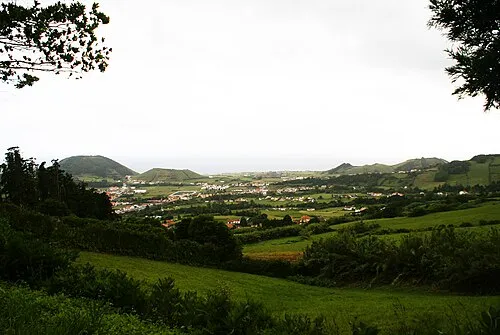
Monte Carneiro José Luís Ávila Silveira/Pedro Noronha e Costa · Public domain

Climate of Tambroso
Best months for sightseeingBest months for sightseeing: July–September.
This month · November
A wet month
Day 17° · Night 12° · Rain 136 mm
- Hottest month
- August (day 23°)
- Coldest month
- February (night 9°)
- Wettest month
- January (163 mm)
- Driest month
- July (43 mm)
Bars: average monthly low and high temperature. Below: precipitation. Monthly averages for 1970–2000 at about 18 km resolution, adjusted for elevation. Highlighted months are mild and relatively dry. Source: WorldClim 2.1 (CC BY 4.0).
Show values as a table
| Month | Jan | Feb | Mar | Apr | May | Jun | Jul | Aug | Sep | Oct | Nov | Dec |
|---|---|---|---|---|---|---|---|---|---|---|---|---|
| Average high (°C) | 14° | 14° | 14° | 15° | 17° | 19° | 22° | 23° | 22° | 19° | 17° | 15° |
| Average low (°C) | 9° | 9° | 9° | 10° | 11° | 13° | 16° | 17° | 16° | 14° | 12° | 10° |
| Precipitation (mm) | 163 | 122 | 113 | 86 | 75 | 52 | 43 | 60 | 96 | 128 | 136 | 151 |
How to get to Tambroso
The nearest airport is Horta Airport (HOR), 11 km to the southwest as the crow flies.
Airports
- Horta Airport (HOR) Horta 11 kmsouthwest
- Pico Airport (PIX) Pico Island 19 kmeast
- São Jorge Airport (SJZ) Velas 42 kmeast
Straight-line distances; road distances are longer. Airport data: OurAirports.
Day trips from Tambroso
Within 100 km: 1 historic or cultural site, 117 natural sites, 7 lakes, rivers and coasts.
0–25 km34 places
- Cabeço Brasil Mountain 16 kmSE
- Ilheu Negro Island 9 kmS
- Ilhéu das Mocas Island 24 kmSE
- Cabeço Verde Mountain 10 kmW
25–60 km88 places
- Cabeço da Rochinha Mountain 50 kmSE
- Cabeço do Caminho Escuro Mountain 53 kmE
- Cabeço da Hera Mountain 56 kmE
- Cabeço da Junca Mountain 55 kmE
60–100 km3 places
- Serra das Fontes Mountain 75 kmNE
- Serra da Dormida Mountain 73 kmNE
- Facho Mountain 76 kmNE
Straight-line distances.
Nearest towns and villages
-
Pedro Miguel Municipality, Horta Municipality2.1 km S
-
Salão Municipality, Horta Municipality2.6 km W
-
Praia do Almoxarife Municipality, Horta Municipality3.8 km S
-
Cedros Municipality, Horta Municipality4.8 km W
-
Flamengos Municipality, Horta Municipality4.9 km SW
-
Cedros Village, Cedros5.5 km NW
Nearby attractions & nature
Everything nearby-
Alto da Cruz Mountain, Ribeirinha2 km SE
-
Porto da Redonda Mountain, Ribeirinha4.2 km E
-
Monte Carneiro Mountain, Horta (Matriz)6.7 km S
-
Alto da Baleia Mountain, Cedros7.5 km NW
-
Monte Queimado Mountain, Horta (Angústias)8.5 km S
-
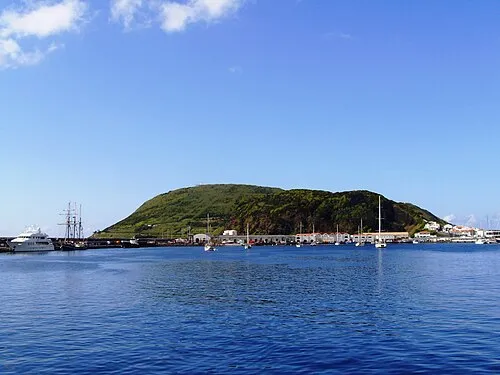 Monte da Guia Mountain, Horta (Angústias)9.2 km S
-
Cabeço Verde Mountain, Capelo10 km W
-
Ilheu Negro Island, Horta (Angústias)9 km S
Sources & licences
Data last updated: · 2 independent sources