Vale de Évora
Located in Mértola, Mértola Municipality Coordinates: 37°40′02″ N 7°40′35″ W
- Elevation
- 123 m
- above sea level
- Local time
- UTC+00:00
- Europe/Lisbon · UTC+00:00
- Airports
- FAO Faro - Gago Coutinho International Airport77 km
- PRM Portimão Airport99 km
About Vale de Évora
Vale de Évora is a natural site. Location: Mértola, Mértola Municipality. The best months to visit are March–May, October. The nearest airport is Faro - Gago Coutinho International Airport (77 km). Nearby sights include Castelo de Mértola and Serra de São Barão.
Photos of Vale de Évora
-
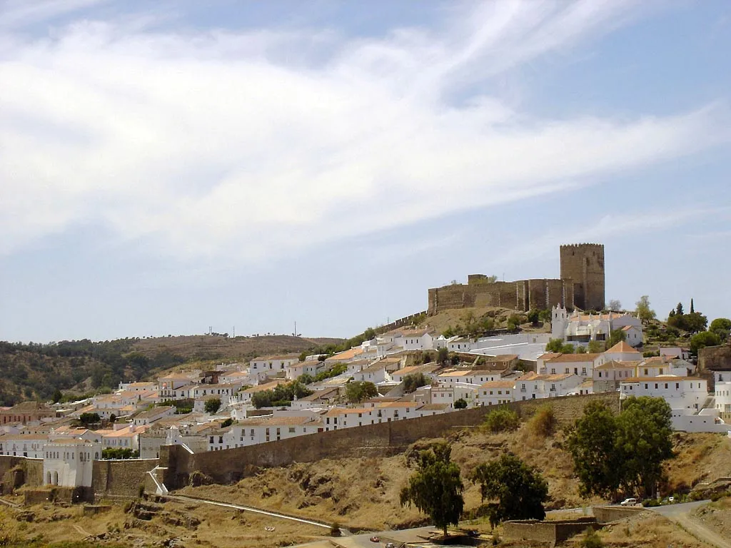
Castelo de Mértola Miguel Vieira · CC BY 2.0

Climate of Vale de Évora
Best months for sightseeingBest months for sightseeing: March–May, October.
This month · November
Outside the best season
Day 19° · Night 10° · Rain 72 mm
- Hottest month
- July (day 33°)
- Coldest month
- January (night 6°)
- Wettest month
- December (97 mm)
- Driest month
- July (3 mm)
Bars: average monthly low and high temperature. Below: precipitation. Monthly averages for 1970–2000 at about 18 km resolution, adjusted for elevation. Highlighted months are mild and relatively dry. Source: WorldClim 2.1 (CC BY 4.0).
Show values as a table
| Month | Jan | Feb | Mar | Apr | May | Jun | Jul | Aug | Sep | Oct | Nov | Dec |
|---|---|---|---|---|---|---|---|---|---|---|---|---|
| Average high (°C) | 15° | 16° | 19° | 20° | 24° | 29° | 33° | 33° | 29° | 24° | 19° | 16° |
| Average low (°C) | 6° | 7° | 8° | 9° | 11° | 15° | 17° | 17° | 16° | 13° | 10° | 7° |
| Precipitation (mm) | 77 | 56 | 42 | 54 | 39 | 16 | 3 | 4 | 21 | 60 | 72 | 97 |
Other places to visit in this season: March April May October
How to get to Vale de Évora
The nearest airport is Faro - Gago Coutinho International Airport (FAO), 77 km to the south as the crow flies. The nearest large city is Huelva, 79 km to the southeast.
Airports
- Faro - Gago Coutinho International Airport (FAO) Faro 77 kmsouth
- Portimão Airport (PRM) Portimão 99 kmsouthwest
- Badajoz Airport (BJZ) Badajoz 155 kmnortheast
Nearby large cities
- Huelva Population: 144.3K 79 kmsoutheast
- Setúbal Population: 118.2K 143 kmnorthwest
- Badajoz Population: 150.5K 148 kmnortheast
- Seville Population: 686.7K 154 kmeast
- Dos Hermanas Population: 122.9K 161 kmeast
Straight-line distances; road distances are longer. Airport data: OurAirports.
Day trips from Vale de Évora
Within 100 km: 106 historic and cultural sites, 58 natural sites, 190 lakes, rivers and coasts.
0–25 km7 places
- Serra de Serpa Mountain 20 kmNE
- Ribera de Malagón River 19 kmSE
- Ribera de Chanza River 19 kmSE
- Serra de Alvares Mountain 10 kmW
25–60 km95 places
- Arroyo del Membrillo River 47 kmSE
- Arroyo del Cuco River 45 kmSE
- Arroyo de los Caballejos River 49 kmSE
- Rivera Pelada River 60 kmE
60–100 km252 places
- Ribeiro dos Saus River 83 kmNE
- Arroyo del Higuerón River 95 kmNE
- Barranco Ríofrío River 92 kmNE
- Arroyo del Tortillo River 82 kmNE
Straight-line distances.
Nearest towns and villages
-
São João dos Caldeireiros Municipality, Mértola Municipality13 km W
-
Santana de Cambas Municipality, Mértola Municipality13 km E
-
Espírito Santo Municipality, Mértola Municipality13 km S
-
Minas de São Domingos Village, Corte do Pinto16 km E
-
Alcaria Ruiva Municipality, Mértola Municipality16 km NW
-
Corte do Pinto Municipality, Mértola Municipality18 km E
Nearby attractions & nature
Everything nearby-
Castelo de Mértola Historic site, Mértola3.4 km S
-
Serra de São Barão Mountain, Mértola5.9 km W
-
Serra de Alcaria Ruiva Mountain, Alcaria Ruiva8.1 km NW
-
Serra de Alvares Mountain, São João dos Caldeireiros9.6 km W
-
Serra de Serpa Mountain, Beja District20 km NE
-
Ribera de Chanza River, Spain19 km SE
-
Ribera de Malagón River, Almendro, El19 km SE
Sources & licences
Data last updated: · 2 independent sources