União das freguesias de Caçarelhos e Angueira
Located in Vimioso Municipality, Braganza District Coordinates: 41°35′16″ N 6°25′25″ W
- Population
- 296
- 296
- Elevation
- 771 m
- above sea level
- Local time
- UTC+00:00
- Europe/Lisbon · UTC+00:00
- Airports
- BGC Bragança Airport38 km
- SLM Salamanca Airport105 km
About União das freguesias de Caçarelhos e Angueira
União das freguesias de Caçarelhos e Angueira is a municipality. Location: Vimioso Municipality, Braganza District. Population: 296. Elevation: 771 m. The best months to visit are June–September. The nearest airport is Bragança Airport (38 km). Nearby sights include Castelo de Algoso and Sierra de Casica.
Climate of União das freguesias de Caçarelhos e Angueira
Best months for sightseeingBest months for sightseeing: June–September.
This month · November
A wet month
Day 12° · Night 4° · Rain 106 mm
- Hottest month
- July (day 28°)
- Coldest month
- January (night 0°)
- Wettest month
- December (132 mm)
- Driest month
- July (18 mm)
Bars: average monthly low and high temperature. Below: precipitation. Monthly averages for 1970–2000 at about 18 km resolution, adjusted for elevation. Highlighted months are mild and relatively dry. Source: WorldClim 2.1 (CC BY 4.0).
Show values as a table
| Month | Jan | Feb | Mar | Apr | May | Jun | Jul | Aug | Sep | Oct | Nov | Dec |
|---|---|---|---|---|---|---|---|---|---|---|---|---|
| Average high (°C) | 8° | 10° | 13° | 15° | 18° | 24° | 28° | 28° | 24° | 18° | 12° | 10° |
| Average low (°C) | 0° | 1° | 3° | 4° | 7° | 11° | 13° | 13° | 11° | 7° | 4° | 2° |
| Precipitation (mm) | 123 | 111 | 65 | 70 | 71 | 46 | 18 | 18 | 47 | 96 | 106 | 132 |
Other places to visit in this season: June July August September
How to get to União das freguesias de Caçarelhos e Angueira
The nearest airport is Bragança Airport (BGC), 38 km to the northwest as the crow flies. The nearest large city is Salamanca, 94 km to the southeast.
Airports
- Bragança Airport (BGC) Bragança 38 kmnorthwest
- Salamanca Airport (SLM) Salamanca 105 kmsoutheast
- Vila Real Airport (VRL) Vila Real 114 kmwest
Nearby large cities
- Salamanca Population: 144.8K 94 kmsoutheast
- León Population: 124.8K 133 kmnortheast
- Valladolid Population: 300.6K 142 kmeast
- Ourense Population: 105.2K 146 kmnorthwest
- Braga Population: 193.3K 167 kmwest
Straight-line distances; road distances are longer. Airport data: OurAirports.
Day trips from União das freguesias de Caçarelhos e Angueira
Within 100 km: 72 historic and cultural sites, 109 natural sites, 216 lakes, rivers and coasts.
0–25 km14 places
- Sierra de Casica Mountain 11 kmN
- Arroyo de Fuentelarraya River 24 kmE
- Río de las Cuevas River 16 kmNW
- Río Colmenares River 16 kmNW
25–60 km140 places
- Embalse de Ricobayo Lake 48 kmE
- Embalse del Esla Lake 42 kmE
- Sierra de la Gamoneda Mountain 57 kmNW
- Teso Santo Mountain 60 kmSE
60–100 km243 places
- Serra da Garraia Mountain 82 kmW
- Lago de Sanabria Lake 64 kmN
- Serra do Invernadoiro Mountain 98 kmNW
- Monte Uzal Mountain 89 kmNW
Straight-line distances.
Nearby attractions & nature
Everything nearby-
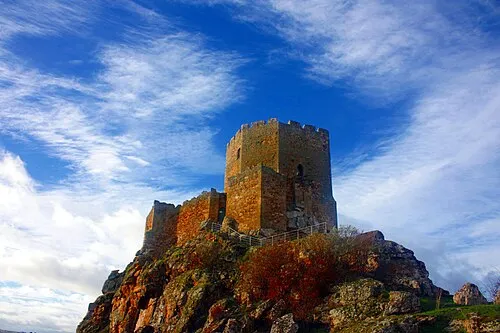 Castelo de Algoso Historic site, União das freguesias de Algoso, Campo de Víboras e Uva19 km SW
-
Sierra de Casica Mountain, Spain11 km N
-
Picão do Coxo Mountain, União das freguesias de Algoso, Campo de Víboras e Uva19 km SW
-
Alto da Canada Mountain, Travanca24 km S
-
Valle del Duero Natural site, Torregamones18 km SE
-
Río de San Mamed River, Trabazos14 km NW
-
Río de las Cuevas River, Trabazos16 km NW
-
Río Colmenares River, Trabazos16 km NW
Sources & licences
Data last updated: