Outeiro do Chouriço
Located in Santiago Maior, Alandroal Municipality Coordinates: 38°32′56″ N 7°29′52″ W
- Elevation
- 282 m
- above sea level
- Local time
- UTC+00:00
- Europe/Lisbon · UTC+00:00
- Airports
- BJZ Badajoz Airport70 km
- LIS Lisbon Humberto Delgado Airport145 km
About Outeiro do Chouriço
Outeiro do Chouriço is a mountain. Location: Santiago Maior, Alandroal Municipality. Elevation: 282 m. The best months to visit are May–June, October. The nearest airport is Badajoz Airport (70 km). Nearby sights include Pedra do Cavalo and Pedra da Negra.
Climate of Outeiro do Chouriço
Best months for sightseeingBest months for sightseeing: May–June, October.
This month · November
Outside the best season
Day 17° · Night 8° · Rain 76 mm
- Hottest month
- August (day 31°)
- Coldest month
- January (night 4°)
- Wettest month
- December (88 mm)
- Driest month
- July (4 mm)
Bars: average monthly low and high temperature. Below: precipitation. Monthly averages for 1970–2000 at about 18 km resolution, adjusted for elevation. Highlighted months are mild and relatively dry. Source: WorldClim 2.1 (CC BY 4.0).
Show values as a table
| Month | Jan | Feb | Mar | Apr | May | Jun | Jul | Aug | Sep | Oct | Nov | Dec |
|---|---|---|---|---|---|---|---|---|---|---|---|---|
| Average high (°C) | 14° | 15° | 18° | 19° | 22° | 27° | 31° | 31° | 28° | 22° | 17° | 14° |
| Average low (°C) | 4° | 5° | 6° | 8° | 10° | 13° | 15° | 15° | 14° | 11° | 8° | 5° |
| Precipitation (mm) | 75 | 62 | 47 | 58 | 47 | 21 | 4 | 5 | 27 | 64 | 76 | 88 |
How to get to Outeiro do Chouriço
The nearest airport is Badajoz Airport (BJZ), 70 km to the northeast as the crow flies. For international flights: Lisbon Humberto Delgado Airport (LIS) (145 km). The nearest large city is Badajoz, 59 km to the northeast.
Airports
- Badajoz Airport (BJZ) Badajoz 70 kmnortheast
- Lisbon Humberto Delgado Airport (LIS) Lisbon 145 kmwest
- Cascais Airport (CAT) Cascais 163 kmwest
Nearby large cities
- Badajoz Population: 150.5K 59 kmnortheast
- Setúbal Population: 118.2K 121 kmwest
- Lisbon Population: 517.8K 145 kmwest
- Huelva Population: 144.3K 151 kmsouth
- Seville Population: 686.7K 186 kmsoutheast
Straight-line distances; road distances are longer. Airport data: OurAirports.
Day trips from Outeiro do Chouriço
Within 100 km: 69 historic and cultural sites, 96 natural sites, 110 lakes, rivers and coasts.
0–25 km9 places
- Arroyo del Trazo River 24 kmE
- Rivera de Táliga River 22 kmE
- Arroyo Friegamuñoz River 22 kmSE
- Ribeira de Cuncos River 19 kmSE
25–60 km58 places
- Sierra Morena Mountain 43 kmE
- Parque de Castelar Natural site 58 kmNE
- Parque de La Legión Natural site 59 kmNE
- Alcazaba Park Natural site 59 kmNE
60–100 km208 places
- Vale do Corvo Natural site 73 kmW
- Vale Costado Natural site 77 kmNW
- Pantano de la Peña del Águila Lake 90 kmNE
- Laguna Grande Lake 67 kmE
Straight-line distances.
Nearest towns and villages
-
Montoito Municipality, Redondo Municipality8.6 km SW
-
Terena (São Pedro) Municipality, Alandroal Municipality9.6 km NE
-
Corval Municipality, Reguengos de Monsaraz Municipality11 km S
-
Reguengos de Monsaraz Municipality, Reguengos de Monsaraz Municipality14 km S
-
Redondo Municipality, Redondo Municipality14 km NW
-
Capelins (Santo António) Municipality, Alandroal Municipality14 km E
Nearby attractions & nature
Everything nearby-
Pedra do Cavalo Mountain, Santiago Maior3.5 km W
-
Pedra da Negra Mountain, Redondo5.7 km NW
-
Outeiro da Sentinela Mountain, Capelins (Santo António)16 km E
-
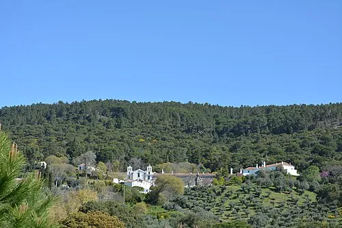 Serra de Ossa Mountain, Évora District21 km NW
-
Arroyo Friegamuñoz River, Villanueva del Fresno22 km SE
-
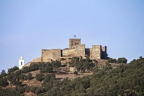 Castelo de Monsaraz Historic site, Monsaraz16 km SE
-
Ribeira de Cuncos River, Spain19 km SE
-
Arroyo del Trazo River, Alconchel24 km E
Sources & licences
Data last updated: · 2 independent sources