Santa Eulália
Located in Elvas Municipality, Portalegre District Coordinates: 39°00′10″ N 7°15′03″ W
- Population
- 1,028
- 1K
- Elevation
- 262 m
- above sea level
- Local time
- UTC+00:00
- Europe/Lisbon · UTC+00:00
- Places inside
- 1
- listed under Santa Eulália
- Airports
- BJZ Badajoz Airport39 km
- LIS Lisbon Humberto Delgado Airport165 km
About Santa Eulália
Santa Eulália is a municipality. Location: Elvas Municipality, Portalegre District. Population: 1,028. Elevation: 262 m. The best months to visit are May, October. The nearest airport is Badajoz Airport (39 km). Nearby sights include Alto dos Ripados and Forte de Santa Luzia.
Climate of Santa Eulália
Best months for sightseeingBest months for sightseeing: May, October.
This month · November
Outside the best season
Day 17° · Night 8° · Rain 82 mm
- Hottest month
- July (day 32°)
- Coldest month
- January (night 5°)
- Wettest month
- November (82 mm)
- Driest month
- July (5 mm)
Bars: average monthly low and high temperature. Below: precipitation. Monthly averages for 1970–2000 at about 18 km resolution, adjusted for elevation. Highlighted months are mild and relatively dry. Source: WorldClim 2.1 (CC BY 4.0).
Show values as a table
| Month | Jan | Feb | Mar | Apr | May | Jun | Jul | Aug | Sep | Oct | Nov | Dec |
|---|---|---|---|---|---|---|---|---|---|---|---|---|
| Average high (°C) | 13° | 15° | 18° | 19° | 23° | 28° | 32° | 32° | 29° | 22° | 17° | 14° |
| Average low (°C) | 5° | 6° | 7° | 8° | 11° | 14° | 17° | 17° | 15° | 12° | 8° | 6° |
| Precipitation (mm) | 71 | 66 | 60 | 54 | 48 | 24 | 5 | 6 | 31 | 64 | 82 | 81 |
How to get to Santa Eulália
The nearest airport is Badajoz Airport (BJZ), 39 km to the east as the crow flies. For international flights: Lisbon Humberto Delgado Airport (LIS) (165 km). The nearest large city is Badajoz, 28 km to the southeast.
Airports
- Badajoz Airport (BJZ) Badajoz 39 kmeast
- Lisbon Humberto Delgado Airport (LIS) Lisbon 165 kmwest
- Cascais Airport (CAT) Cascais 185 kmwest
Nearby large cities
- Badajoz Population: 150.5K 28 kmsoutheast
- Setúbal Population: 118.2K 152 kmwest
- Lisbon Population: 517.8K 168 kmwest
- Huelva Population: 144.3K 195 kmsouth
- Seville Population: 686.7K 212 kmsoutheast
Straight-line distances; road distances are longer. Airport data: OurAirports.
Places in Santa Eulália
1 placeMountains & nature1
- Alto da Esparregueira · Mountain
Nearby attractions & nature
Everything nearby-
Alto dos Ripados Mountain, Monforte8.2 km W
-
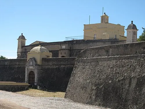 Forte de Santa Luzia Historic site, Assunção, Ajuda, Salvador e Santo Ildefonso17 km SE
-
Castelo de Arronches Historic site, Assunção14 km N
-
Cabeço do Mourato Mountain, Assunção15 km NE
-
Serra da Pedra Torta Mountain, Esperança18 km NE
-
Serra da Chugueira Mountain, Esperança19 km NE
-
Castillo de La Beltraneja Historic site, Codosera, La23 km N
-
Parroquia Nuestra Señora de la Piedad Attraction, Codosera, La23 km N
Sources & licences
Data last updated: