- Population
- 15
- 15
- Elevation
- 276 m
- above sea level
- Local time
- UTC+00:00
- Europe/Lisbon · UTC+00:00
- Airports
- VSE Aerodromo Goncalves Lobato (Viseu Airport)117 km
- BJZ Badajoz Airport132 km
About Arganil
Arganil is a village. Location: Cardigos, Mação Municipality. Population: 15. Elevation: 276 m. The best months to visit are May–June, September–October. The nearest airport is Aerodromo Goncalves Lobato (Viseu Airport) (117 km). Nearby sights include Serra da Amêndoa and Castle of Amieira do Tejo.
Climate of Arganil
Best months for sightseeingBest months for sightseeing: May–June, September–October.
This month · November
A wet month
Day 16° · Night 9° · Rain 117 mm
- Hottest month
- August (day 31°)
- Coldest month
- January (night 6°)
- Wettest month
- January (139 mm)
- Driest month
- July (9 mm)
Bars: average monthly low and high temperature. Below: precipitation. Monthly averages for 1970–2000 at about 18 km resolution, adjusted for elevation. Highlighted months are mild and relatively dry. Source: WorldClim 2.1 (CC BY 4.0).
Show values as a table
| Month | Jan | Feb | Mar | Apr | May | Jun | Jul | Aug | Sep | Oct | Nov | Dec |
|---|---|---|---|---|---|---|---|---|---|---|---|---|
| Average high (°C) | 13° | 14° | 17° | 19° | 22° | 27° | 30° | 31° | 27° | 21° | 16° | 13° |
| Average low (°C) | 6° | 6° | 8° | 9° | 12° | 15° | 17° | 17° | 16° | 13° | 9° | 7° |
| Precipitation (mm) | 139 | 111 | 96 | 82 | 70 | 33 | 9 | 10 | 42 | 98 | 117 | 139 |
Other places to visit in this season: May June September October
How to get to Arganil
The nearest airport is Aerodromo Goncalves Lobato (Viseu Airport) (VSE), 117 km to the north as the crow flies. For international flights: Lisbon Humberto Delgado Airport (LIS) (141 km). The nearest large city is Badajoz, 124 km to the southeast.
Airports
- Aerodromo Goncalves Lobato (Viseu Airport) (VSE) Viseu 117 kmnorth
- Badajoz Airport (BJZ) Badajoz 132 kmsoutheast
- Lisbon Humberto Delgado Airport (LIS) Lisbon 141 kmsouthwest
Nearby large cities
- Badajoz Population: 150.5K 124 kmsoutheast
- Lisbon Population: 517.8K 146 kmsouthwest
- Setúbal Population: 118.2K 150 kmsouthwest
- Porto Population: 252.7K 172 kmnorth
- Braga Population: 193.3K 212 kmnorth
Straight-line distances; road distances are longer. Airport data: OurAirports.
Day trips from Arganil
Within 100 km: 33 historic and cultural sites, 168 natural sites, 22 lakes, rivers and coasts.
0–25 km9 places
- Alto do Vale de Colmeias Mountain 23 kmS
- Serra de São Domingos Mountain 22 kmNW
- Alto do Pé da Travessa Mountain 22 kmS
- Serra do Carujo Mountain 25 kmN
25–60 km78 places
- Sapateira Grande Mountain 59 kmSE
- Río Alburrel River 53 kmE
- Ribera Aurela River 56 kmE
- Cabeço das Lamas Mountain 50 kmN
60–100 km136 places
- Vale Costado Natural site 96 kmS
- Rio Xévora River 96 kmSE
- Arroyo Canito River 76 kmE
- Rio Erges River 82 kmE
Straight-line distances.
Nearby attractions & nature
Everything nearby-
Serra da Amêndoa Mountain, Santarém District4.4 km SW
-
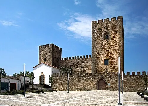 Castle of Amieira do Tejo Historic site, União das freguesias de Arez e Amieira do Tejo23 km SE
-
Serra do Cabeço Rainha Mountain, Castelo Branco District20 km N
-
Serra do Carujo Mountain, Oleiros-Amieira25 km N
-
Alto do Pé da Travessa Mountain, Belver22 km S
-
Alto do Vale de Colmeias Mountain, União das freguesias de Gavião e Atalaia23 km S
Sources & licences
Data last updated: