Mentrestido
Located in Vila Nova de Cerveira Municipality, Viana do Castelo District Coordinates: 41°53′59″ N 8°40′02″ W
- Population
- 273
- 273
- Elevation
- 188 m
- above sea level
- Local time
- UTC+00:00
- Europe/Lisbon · UTC+00:00
- Airports
- VGO Vigo Airport37 km
- OPO Francisco de Sá Carneiro Airport72 km
About Mentrestido
Mentrestido is a municipality. Location: Vila Nova de Cerveira Municipality, Viana do Castelo District. Population: 273. Elevation: 188 m. The best months to visit are June–September. The nearest airport is Vigo Airport (37 km). Nearby sights include Monte do Forte and Serra da Salgosa.
Climate of Mentrestido
Best months for sightseeingBest months for sightseeing: June–September.
This month · November
A wet month
Day 15° · Night 8° · Rain 186 mm
- Hottest month
- July (day 24°)
- Coldest month
- January (night 5°)
- Wettest month
- December (229 mm)
- Driest month
- July (31 mm)
Bars: average monthly low and high temperature. Below: precipitation. Monthly averages for 1970–2000 at about 18 km resolution, adjusted for elevation. Highlighted months are mild and relatively dry. Source: WorldClim 2.1 (CC BY 4.0).
Show values as a table
| Month | Jan | Feb | Mar | Apr | May | Jun | Jul | Aug | Sep | Oct | Nov | Dec |
|---|---|---|---|---|---|---|---|---|---|---|---|---|
| Average high (°C) | 12° | 13° | 15° | 16° | 18° | 22° | 24° | 24° | 22° | 19° | 15° | 12° |
| Average low (°C) | 5° | 6° | 7° | 8° | 10° | 13° | 14° | 14° | 13° | 11° | 8° | 6° |
| Precipitation (mm) | 216 | 189 | 134 | 124 | 114 | 64 | 31 | 32 | 94 | 168 | 186 | 229 |
Other places to visit in this season: June July August September
How to get to Mentrestido
The nearest airport is Vigo Airport (VGO), 37 km to the north as the crow flies. For international flights: Francisco de Sá Carneiro Airport (OPO) (72 km). The nearest large city is Vigo, 37 km to the north.
Airports
- Vigo Airport (VGO) Vigo 37 kmnorth
- Francisco de Sá Carneiro Airport (OPO) Porto 72 kmsouth
- Vila Real Airport (VRL) Vila Real 105 kmsoutheast
Nearby large cities
- Vigo Population: 293.6K 37 kmnorth
- Braga Population: 193.3K 44 kmsoutheast
- Ourense Population: 105.2K 82 kmnortheast
- Porto Population: 252.7K 84 kmsouth
- A Coruña Population: 250.4K 165 kmnorth
Straight-line distances; road distances are longer. Airport data: OurAirports.
Day trips from Mentrestido
Within 100 km: 164 historic and cultural sites, 208 natural sites, 309 lakes, rivers and coasts.
0–25 km42 places
- Praia de Areeiros Beach 18 kmN
- Illa Ariño da Pasaxe Island 15 kmW
- Monte de Santa Trega Mountain 17 kmW
- Serra da Groba Mountain 21 kmNW
25–60 km306 places
- Illa de Ons Island 58 kmN
- Islas Cíes Island 40 kmNW
- Playa de San Martín Beach 39 kmNW
- Playa de Roda Beach 40 kmNW
60–100 km333 places
- Illa de Arousa Island 74 kmN
- A Illa da Toxa Island 67 kmN
- Praia da Lagoa Beach 81 kmN
- Playa Vilagarcía Beach 79 kmN
Straight-line distances.
Nearby attractions & nature
Everything nearby-
Monte do Forte Mountain, Sapardos3.7 km N
-
Serra da Salgosa Mountain, União das freguesias de Candemil e Gondar4.6 km NW
-
Serra da Gávea Mountain, União das freguesias de Vila Nova de Cerveira e Lovelhe5.5 km NW
-
Serra de Gois Mountain, Viana do Castelo District9.6 km W
-
Isla Motraceira Island, Tomiño9 km NW
-
Serra do Formigoso Mountain, Cabração e Moreira do Lima10 km S
-
Isla Vaqueriza Island, Tomiño9.8 km NW
-
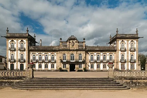 Brejoeira Palace Historic site, Pinheiros21 km NE
Sources & licences
Data last updated: