- Population
- 2,698
- 2.7K
- Elevation
- 5 m
- above sea level
- Local time
- UTC+03:00
- Europe/Istanbul · UTC+03:00
- Airports
- SMI Samos Airport42 km
- BJV Milas Bodrum International Airport44 km
About Sarıkemer
Sarıkemer is a village. Location: Söke İlçesi, Aydın Province. Population: 2,698. Elevation: 5 m.
Sarıkemer is a neighbourhood of the municipality and district of Söke, Aydın Province, Turkey. Its population is 2,103 (2022). Before the 2013 reorganisation, it was a town (belde). It is situated in the alluvial plain of the Büyükmenderes River, known as the Maeander in antiquity, which flows within the town. Sarıkemer is 24 kilometres (15 mi) south of Söke and 75 kilometres (47 mi) southwest of Aydın. The main economic activity of the town is cotton farming.
Source: Wikipedia · CC BY-SA 4.0
Climate of Sarıkemer
Best months for sightseeingBest months for sightseeing: April–May, October.
This month · November
Outside the best season
Day 19° · Night 10° · Rain 88 mm
Better nearby cities in November
- Aydin · 52 km northeast19°
- Hottest month
- July (day 34°)
- Coldest month
- January (night 6°)
- Wettest month
- December (147 mm)
- Driest month
- July (3 mm)
Bars: average monthly low and high temperature. Below: precipitation. Monthly averages for 1970–2000 at about 18 km resolution, adjusted for elevation. Highlighted months are mild and relatively dry. Source: WorldClim 2.1 (CC BY 4.0).
Show values as a table
| Month | Jan | Feb | Mar | Apr | May | Jun | Jul | Aug | Sep | Oct | Nov | Dec |
|---|---|---|---|---|---|---|---|---|---|---|---|---|
| Average high (°C) | 13° | 14° | 17° | 22° | 27° | 32° | 34° | 33° | 30° | 25° | 19° | 15° |
| Average low (°C) | 6° | 6° | 8° | 11° | 15° | 19° | 21° | 21° | 18° | 14° | 10° | 7° |
| Precipitation (mm) | 140 | 107 | 77 | 43 | 22 | 10 | 3 | 4 | 18 | 41 | 88 | 147 |
How to get to Sarıkemer
The nearest airport is Samos Airport (SMI), 42 km to the west as the crow flies. For international flights: Milas Bodrum International Airport (BJV) (44 km). The nearest large city is Aydin, 52 km to the northeast.
Airports
- Samos Airport (SMI) Samos Island 42 kmwest
- Milas Bodrum International Airport (BJV) Bodrum 44 kmsoutheast
- Adnan Menderes International Airport (ADB) Gaziemir 83 kmnorth
Nearby large cities
- Aydin Population: 163K 52 kmnortheast
- Nazilli Population: 119.4K 93 kmnortheast
- Karabağlar Population: 479.3K 93 kmnorth
- Konak Population: 332.3K 95 kmnorth
- Izmir Population: 2.9M 96 kmnorth
Straight-line distances; road distances are longer. Airport data: OurAirports.
Day trips from Sarıkemer
Within 100 km: 99 historic and cultural sites, 179 natural sites, 186 lakes, rivers and coasts.
0–25 km38 places
- Didem Plajı Beach 25 kmS
- Dil Adaları Island 15 kmW
- Gökada Island 24 kmS
- Saplı Adası Island 18 kmS
25–60 km173 places
- Moní Megális Panagías Attraction 48 kmW
- Iasos Historic site 38 kmSE
- Kadınlar Plajı Beach 33 kmN
- Gümbet Plajı Beach 59 kmS
60–100 km253 places
- Nisída Krevvatió Island 74 kmS
- Karabel relief Historic site 90 kmN
- Paşatarlası Plajı Beach 60 kmS
- Taşlık Plajı Beach 98 kmS
Straight-line distances.
Nearby attractions & nature
Everything nearby-
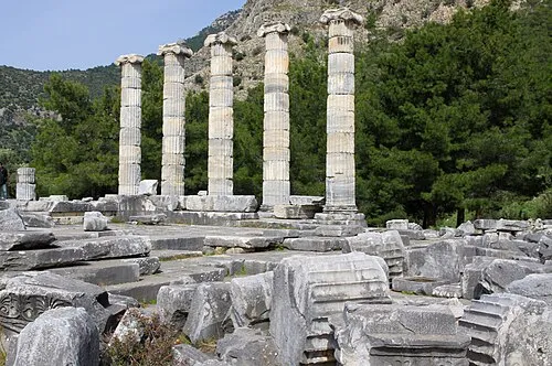 Priene Historic site, Söke İlçesi12 km NW
-
Myos Historic site, Söke İlçesi6.8 km NE
-
Milet Harabeleri Historic site, Didim8.5 km SW
-
Kızmezar Tepe Mountain, Söke İlçesi9.4 km NE
-
Miletos Historic site, Didim8.8 km SW
-
Faustina baths Historic site, Didim8.8 km SW
Sources & licences
Data last updated: · 2 independent sources