Çanakkale Province
Local name: Çanakkale ili
Located in Turkey Coordinates: 40°05′00″ N 26°50′00″ E

- Population
- 573,976
- 574K
- Elevation
- 410 m
- above sea level
- Local time
- UTC+03:00
- Europe/Istanbul · UTC+03:00
- Places inside
- 246
- listed under Çanakkale Province
- Airports
- CKZ Çanakkale Airport35 km
- EDO Balıkesir Koca Seyit Airport61 km
About Çanakkale Province
Çanakkale Province is a region. Location: Turkey. Population: 573,976.
Çanakkale Province (Turkish: Çanakkale ili) is a province of Turkey, located in the northwestern part of the country. It takes its name from the city of Çanakkale. Its area is 9,817 km2, and its population is 559,383 (2022). Similar to Istanbul, Çanakkale province spans Europe (Thrace) and Asia (Anatolia). The European part is formed by the Gallipoli peninsula, while the Asian part is largely coterminous with the historic region of Troad in Anatolia.
Source: Wikipedia · CC BY-SA 4.0
Photos of Çanakkale Province
-
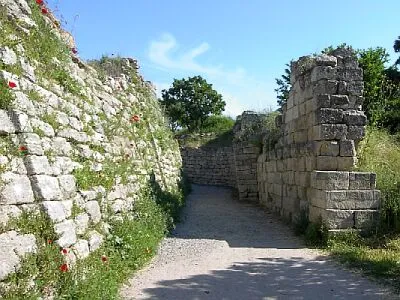
Troy Wikimedia Commons · CC BY-SA 3.0 -
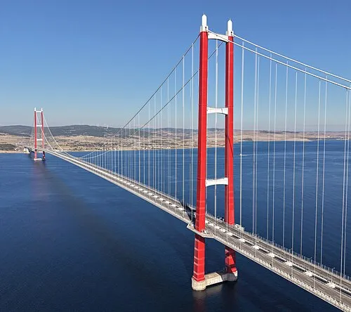
1915 Çanakkale Bridge Glabb · CC BY-SA 3.0


Places bordering Çanakkale Province
Climate of Çanakkale Province
Best months for sightseeingBest months for sightseeing: May–September.
This month · November
Outside the best season
Day 14° · Night 6° · Rain 93 mm
Better nearby cities in November
- Aydin · 264 km south19°
- Hottest month
- July (day 28°)
- Coldest month
- January (night 1°)
- Wettest month
- December (121 mm)
- Driest month
- August (14 mm)
Bars: average monthly low and high temperature. Below: precipitation. Monthly averages for 1970–2000 at about 18 km resolution, adjusted for elevation. Highlighted months are mild and relatively dry. Source: WorldClim 2.1 (CC BY 4.0).
Show values as a table
| Month | Jan | Feb | Mar | Apr | May | Jun | Jul | Aug | Sep | Oct | Nov | Dec |
|---|---|---|---|---|---|---|---|---|---|---|---|---|
| Average high (°C) | 8° | 8° | 11° | 16° | 21° | 26° | 28° | 28° | 24° | 19° | 14° | 10° |
| Average low (°C) | 1° | 1° | 3° | 7° | 11° | 15° | 17° | 17° | 14° | 10° | 6° | 3° |
| Precipitation (mm) | 100 | 84 | 72 | 59 | 45 | 28 | 16 | 14 | 30 | 54 | 93 | 121 |
Other places to visit in this season: May June July August September
How to get to Çanakkale Province
The nearest airport is Çanakkale Airport (CKZ), 35 km to the west as the crow flies. For international flights: Balıkesir Koca Seyit Airport (EDO) (61 km). The nearest large city is Çanakkale, 37 km to the west.
Airports
- Çanakkale Airport (CKZ) Çanakkale 35 kmwest
- Balıkesir Koca Seyit Airport (EDO) Edremit 61 kmsouth
- Balıkesir Airport (BZI) Balıkesir 107 kmsoutheast
Nearby large cities
- Çanakkale Population: 143.6K 37 kmwest
- Bandırma Population: 107.6K 102 kmeast
- Balıkesir Population: 238.2K 102 kmsoutheast
- Tekirdağ Population: 122.3K 115 kmnortheast
- Mustafakemalpaşa Population: 101.4K 134 kmeast
Straight-line distances; road distances are longer. Airport data: OurAirports.
Places in Çanakkale Province
246 places- 1 Canakkale 149.9K
- 2 Biga 85.2K
- 3 Çan İlçesi 50.1K
- 4 Gelibolu İlçesi 43.3K
- 5 Yenice İlçesi 34.5K
- 6 Ezine İlçesi 32.2K
- 7 Ayvacık İlçesi 30.7K
- 8 Bayramiç İlçesi 30.1K
- 9 Lâpseki İlçesi 25.7K
- 10 Gökçeada 10.7K
- 11 Eceabat 9.1K
- 12 Bozcaada 2.6K
Bar: population relative to the most populous place in this list.
Cities & villages9
- Aigospotamos · Village
- Ayvacık Bucağı · Municipality
- Bakacak Bucağı · Municipality
- Balıklıçeşme Bucağı · Municipality
- Bayramiç Bucağı · Municipality
- Beyçayırı Bucağı · Municipality
- Biga Bucağı · Municipality
- Bolayır Bucağı · Municipality
- Bozcaada Bucağı · Municipality
Mountains & nature10
- Akbaş Limanı · Natural site
- Armutçuk Dağı · Mountain
- Bağçeşme Limanı · Natural site
- Baglar Bay · Natural site
- Bassikia Bay · Natural site
- Biga Yarımadası · Natural site
- Biga Yarımadası · Natural site
- Çam Limanı · Natural site
- Çardak Limanı · Natural site
- Dardan Bay · Natural site
Lakes, rivers & coasts27
- Adaçay Deresi · River
- Akyaprak Göleti · Lake
- Aliki Lake · Lake
- Armutçuk Deresi · River
- Azmak Deresi · River
- Bağlar Deresi · River
- Bayram Deresi · River
- Biga Çayı · River
- Biga Çayı · River
- Brighton Beach · Beach
- Büyükada · Island
- Büyükada · Island
- Büyükçay Deresi · River
- Büyük Dere · River
- Büyükhayrettin Tepesi · River
- Buzağılık Deresi · River
- Çalköy Göleti · Lake
- Çamurluburun Dere · River
- Çatalarmut Deresi · River
- Çatalazmak · River
- Çeşme Deresi · River
- Chailak Dere · River
- Chomak Dere · River
- Çıkacak Deresi · River
- Çınar Deresi · River
- Değermen Deresi · River
- Değirmencik Adası · Island
Heritage & sights2
- Bozcaada Kalesi · Historic site
- Çardak Feneri · Landmark
Largest cities and towns
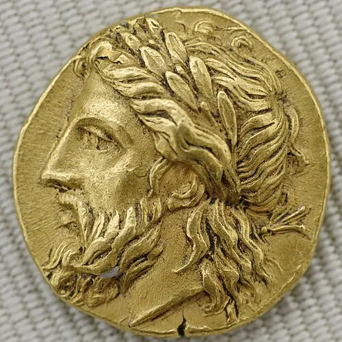
Nature and heritage in Çanakkale Province
Sources & licences
Data last updated: · 2 independent sources