Edirne Province
Local name: Edirne ili
Located in Turkey Coordinates: 41°15′00″ N 26°40′00″ E

- Population
- 414,714
- 414.7K
- Elevation
- 38 m
- above sea level
- Local time
- UTC+03:00
- Europe/Istanbul · UTC+03:00
- Places inside
- 104
- listed under Edirne Province
- Airports
- AXD Alexandroupoli Democritus Airport74 km
- TEQ Tekirdağ Çorlu Airport106 km
About Edirne Province
Edirne Province is a region. Location: Turkey. Population: 414,714.
Edirne Province (Turkish: Edirne ili) is a Turkish province located in East Thrace. Part of European Turkey, it is one of only three provinces located entirely within continental Europe. Its area is 6,145 km2, and its population is 414,714 (2022). Edirne Province is bordered by Tekirdağ Province and Kırklareli Province to the east, and the Gallipoli peninsula of Çanakkale Province to the south-east.
Source: Wikipedia · CC BY-SA 4.0
Photos of Edirne Province
-

Sinan Şahin · CC BY 3.0 -

Sinan Şahin · CC BY 3.0 -

Robot8A · CC BY-SA 4.0 -

Aziz Akbiyik · CC BY-SA 3.0 -

Edal Anton Lefterov · CC BY-SA 3.0


Places bordering Edirne Province
- Çanakkale Province
- Tekirdağ Province
- Kırklareli Province
- East Macedonia and Thrace
- Haskovo
- Yambol
Climate of Edirne Province
Best months for sightseeingBest months for sightseeing: May, September–October.
This month · November
Outside the best season
Day 15° · Night 7° · Rain 83 mm
Better nearby cities in November
- Aydin · 392 km south19°
- Hottest month
- July (day 29°)
- Coldest month
- January (night 2°)
- Wettest month
- December (90 mm)
- Driest month
- August (20 mm)
Bars: average monthly low and high temperature. Below: precipitation. Monthly averages for 1970–2000 at about 18 km resolution, adjusted for elevation. Highlighted months are mild and relatively dry. Source: WorldClim 2.1 (CC BY 4.0).
Show values as a table
| Month | Jan | Feb | Mar | Apr | May | Jun | Jul | Aug | Sep | Oct | Nov | Dec |
|---|---|---|---|---|---|---|---|---|---|---|---|---|
| Average high (°C) | 8° | 8° | 12° | 17° | 23° | 27° | 29° | 29° | 25° | 20° | 15° | 10° |
| Average low (°C) | 2° | 2° | 4° | 7° | 12° | 16° | 18° | 18° | 15° | 11° | 7° | 4° |
| Precipitation (mm) | 71 | 64 | 63 | 50 | 44 | 41 | 24 | 20 | 35 | 60 | 83 | 90 |
How to get to Edirne Province
The nearest airport is Alexandroupoli Democritus Airport (AXD), 74 km to the southwest as the crow flies. The nearest large city is Edirne, 48 km to the north.
Airports
- Alexandroupoli Democritus Airport (AXD) Alexandroupolis 74 kmsouthwest
- Tekirdağ Çorlu Airport (TEQ) Çorlu 106 kmeast
- Çanakkale Airport (CKZ) Çanakkale 125 kmsouth
Nearby large cities
- Edirne Population: 180K 48 kmnorth
- Tekirdağ Population: 122.3K 77 kmsoutheast
- Çorlu Population: 202.6K 96 kmeast
- Çanakkale Population: 143.6K 123 kmsouth
- Bandırma Population: 107.6K 149 kmsoutheast
Straight-line distances; road distances are longer. Airport data: OurAirports.
Places in Edirne Province
104 places- 1 Keşan İlçesi 79.9K
- 2 Uzunköprü İlçesi 65K
- 3 İpsala İlçesi 29K
- 4 Havsa İlçesi 20.2K
- 5 Meriç İlçesi 14.8K
- 6 Enez İlçesi 10.5K
- 7 Süloğlu İlçesi 7.9K
- 8 Lâlapaşa İlçesi 7.2K
- 9 İmampazarı 108
Bar: population relative to the most populous place in this list.
Countries & regions1
- Edirne · District
Cities & villages8
- Çöpköy Bucağı · Municipality
- Enez Bucağı · Municipality
- Hamadiye Bucağı · Municipality
- Hasköy Bucağı · Municipality
- Havsa Bucağı · Municipality
- İbriktepe Bucağı · Municipality
- İpsala Bucağı · Municipality
- Karaksım Bucağı · Municipality
Mountains & nature6
- Cape Gremea · Natural site
- Cape Ibriji · Natural site
- Çınardere Limanı · Natural site
- Erdine Kent Ormanı · Natural site
- Hacı Adil Bey Çeşmesi · Natural site
- Hıdır Baba Tabyaları · Natural site
Lakes, rivers & coasts36
- Aşağıova Deresi · River
- Aydere · River
- Ayvalı Deresi · River
- Azatlı Dere · River
- Bahçe Deresi · River
- Balıklı Dere · River
- Basamaklar Deresi · River
- Çamlıca · River
- Çelberen Deresi · River
- Çeltik Gölü · Lake
- Çiftlik Deresi · River
- Çoban Deresi · River
- Çömlek Deresi · River
- Çöpköy Deresi · River
- Dalyan Gölü · Lake
- Değirmen Deresi · River
- Değirmen Deresi · River
- Değirmen Deresi · River
- Demirci Deresi · River
- Demirciler Deresi · River
- Derventboğazı Deresi · River
- Dişbudak Deresi · River
- Doğanca Deresi · River
- Doğanca Deresi · River
- Doluköy Deresi · River
- Gökgörü Deresi · River
- Hamza Deresi · River
- Hisarlı Deresi · River
- Işık Gölü · Lake
- Iskarlaazmağı · River
- İskenderköy Deresi · River
- Kanal Deresi · River
- Kara Göl · Lake
- Karagöl Deresi · River
- Kavacık Barajı · River
- Kavak Deresi · River
Largest cities and towns
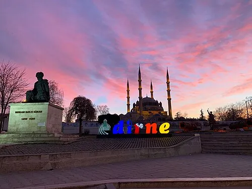

Nature and heritage in Edirne Province
Sources & licences
Data last updated: · 2 independent sources