Giresun Province
Local name: Giresun ili
Located in Turkey Coordinates: 40°30′00″ N 38°30′00″ E
- Population
- 450,862
- 450.9K
- Elevation
- 2,365 m
- above sea level
- Local time
- UTC+03:00
- Europe/Istanbul · UTC+03:00
- Places inside
- 121
- listed under Giresun Province
- Airports
- OGU Ordu–Giresun Airport63 km
- TZX Trabzon International Airport122 km
About Giresun Province
Giresun Province is a region. Location: Turkey. Population: 450,862.
Giresun Province (Turkish: Giresun ili) is a province of Turkey on the Black Sea coast. Its adjacent provinces are Trabzon to the east, Gümüşhane to the southeast, Erzincan to the south, Sivas to the southwest, and Ordu to the west. Its area is 6,972 km2, and its population is 450,862 (2022). The provincial capital is Giresun. Its license-plate code is 28.
Source: Wikipedia · CC BY-SA 4.0
Places bordering Giresun Province
Climate of Giresun Province
Best months for sightseeingBest months for sightseeing: July–August.
This month · November
A cold month
Day 4° · Night -5° · Rain 60 mm
Better nearby cities in November
- Viranşehir · 380 km south18°
- Suruç · 392 km south20°
- Hottest month
- August (day 21°)
- Coldest month
- January (night -12°)
- Wettest month
- May (85 mm)
- Driest month
- August (14 mm)
Bars: average monthly low and high temperature. Below: precipitation. Monthly averages for 1970–2000 at about 18 km resolution, adjusted for elevation. Highlighted months are mild and relatively dry. Source: WorldClim 2.1 (CC BY 4.0).
Show values as a table
| Month | Jan | Feb | Mar | Apr | May | Jun | Jul | Aug | Sep | Oct | Nov | Dec |
|---|---|---|---|---|---|---|---|---|---|---|---|---|
| Average high (°C) | -5° | -3° | 1° | 8° | 13° | 17° | 21° | 21° | 18° | 11° | 4° | -3° |
| Average low (°C) | -12° | -11° | -7° | -2° | 2° | 4° | 7° | 7° | 4° | 0° | -5° | -9° |
| Precipitation (mm) | 51 | 46 | 59 | 80 | 85 | 56 | 17 | 14 | 26 | 50 | 60 | 61 |
How to get to Giresun Province
The nearest airport is Ordu–Giresun Airport (OGU), 63 km to the northwest as the crow flies. The nearest large city is Giresun, 47 km to the north.
Airports
- Ordu–Giresun Airport (OGU) Ordu 63 kmnorthwest
- Trabzon International Airport (TZX) Trabzon 122 kmnortheast
- Erzincan Airport (ERC) Erzincan 124 kmsoutheast
Nearby large cities
- Giresun Population: 125.7K 47 kmnorth
- Ordu Population: 229.2K 74 kmnorthwest
- Trabzon Population: 244.1K 118 kmnortheast
- Erzincan Population: 150.7K 119 kmsoutheast
- Sivas Population: 264K 152 kmsouthwest
Straight-line distances; road distances are longer. Airport data: OurAirports.
Places in Giresun Province
121 places- 1 Giresun 124.1K
- 2 Bulancak İlçesi 61.8K
- 3 Espiye İlçesi 31.8K
- 4 Tirebolu 30.4K
- 5 Görele İlçesi 29.7K
- 6 Şebin Karahisar İlçesi 23.2K
- 7 Dereli 20.9K
- 8 Keşap 20.3K
- 9 Yağlıdere İlçesi 16.8K
- 10 Piraziz İlçesi 13.6K
- 11 Eynesil İlçesi 13.4K
- 12 Alucra İlçesi 9.2K
- 13 Güce İlçesi 8.4K
- 14 Çamoluk İlçesi 7.5K
- 15 Çanakçı 7K
- 16 Doğankent İlçesi 6.9K
Bar: population relative to the most populous place in this list.
Cities & villages11
- Alucra Bucağı · Municipality
- Bulancak Bucağı · Municipality
- Çamoluk Bucağı · Municipality
- Çanakçı Bucağı · Municipality
- Çatköy · Village
- Çıtlaklı · Village
- Çorapçılar · Village
- Denizli · Village
- Dereli Bucağı · Municipality
- Dikmen · Village
- Doğankent Bucağı · Municipality
Lakes, rivers & coasts33
- Aksu Çayı · River
- Alişar Deresi · River
- Alucra Çayı · River
- Arslanyurdu Deresi · River
- Avlucak Deresi · River
- Avutmuş Dere · River
- Bağırsak Deresi · River
- Bağırsak Deresi · River
- Batlama River · River
- Belen Deresi · River
- Beylerce Deresi · River
- Bulancak Deresi · River
- Büyük Dere · River
- Büyük Dere · River
- Büyük Dere · River
- Büyük Dere · River
- Büyükgöre Deresi · River
- Çakıl Deresi · River
- Çakmanos Deresi · River
- Çakrak Deresi · River
- Çanakçı Deresi · River
- Çatak Deresi · River
- Çatalgöl · Lake
- Çivrişan Deresi · River
- Çobanlı Çay · River
- Çömlekçi Dere · River
- Çorak Dere · River
- Damu Deresi · River
- Darıbükü Deresi · River
- Değirmenyanı Deresi · River
- Demirözü Deresi · River
- Doğankent Çayı · River
- Elmacık Deresi · River
Largest cities and towns
Nature and heritage in Giresun Province
Other regions in Turkey
-
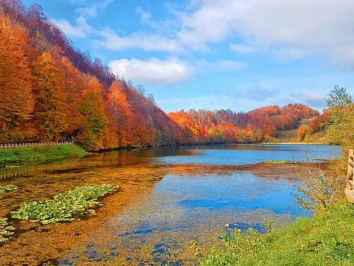 Ordu Region, Turkey83 km NW
-
Akıncılar İlçesi District, Sivas Province49 km S
-
Kürtün İlçesi District, Gümüşhane Province55 km NE
-
Altınordu District, Ordu78 km NW
-
Suşehri İlçesi District, Sivas Province51 km SW
Sources & licences
Data last updated: · 2 independent sources