- Elevation
- 1,319 m
- above sea level
- Local time
- UTC+03:00
- Europe/Istanbul · UTC+03:00
- Airports
- ASR Kayseri Erkilet International Airport10 km
- NAV Nevşehir Kapadokya Airport74 km
About Molu
Molu is a village. Location: Kocasinan, Kayseri Province. Elevation: 1,319 m. The best months to visit are May–June, August–September. The nearest airport is Kayseri Erkilet International Airport (10 km). Nearby sights include Kum Tepe and Saint Gregory the Illuminator Church.
Climate of Molu
Best months for sightseeingBest months for sightseeing: May–June, August–September.
This month · November
A cold month
Day 10° · Night -3° · Rain 37 mm
Better nearby cities in November
- Adana · 202 km south21°
- Osmaniye · 206 km south21°
- Tarsus · 214 km south22°
- Hottest month
- July (day 29°)
- Coldest month
- January (night -8°)
- Wettest month
- April (54 mm)
- Driest month
- August (6 mm)
Bars: average monthly low and high temperature. Below: precipitation. Monthly averages for 1970–2000 at about 18 km resolution, adjusted for elevation. Highlighted months are mild and relatively dry. Source: WorldClim 2.1 (CC BY 4.0).
Show values as a table
| Month | Jan | Feb | Mar | Apr | May | Jun | Jul | Aug | Sep | Oct | Nov | Dec |
|---|---|---|---|---|---|---|---|---|---|---|---|---|
| Average high (°C) | 2° | 4° | 10° | 16° | 20° | 25° | 29° | 28° | 25° | 18° | 10° | 4° |
| Average low (°C) | -8° | -6° | -3° | 2° | 6° | 9° | 11° | 11° | 7° | 2° | -3° | -6° |
| Precipitation (mm) | 35 | 30 | 40 | 54 | 52 | 36 | 10 | 6 | 13 | 30 | 37 | 42 |
Other places to visit in this season: May June August September
How to get to Molu
The nearest airport is Kayseri Erkilet International Airport (ASR), 10 km to the east as the crow flies. The nearest large city is Kayseri, 12 km to the southeast.
Airports
- Kayseri Erkilet International Airport (ASR) Kayseri 10 kmeast
- Nevşehir Kapadokya Airport (NAV) Nevşehir 74 kmwest
- Sivas Nuri Demirağ Airport (VAS) Sivas 173 kmnortheast
Nearby large cities
- Kayseri Population: 1.5M 12 kmsoutheast
- Kırşehir Population: 150.7K 112 kmwest
- Aksaray Population: 327.6K 127 kmwest
- Sivas Population: 264K 176 kmnortheast
- Heraclea Population: 156.3K 185 kmsouthwest
Straight-line distances; road distances are longer. Airport data: OurAirports.
Day trips from Molu
Within 100 km: 15 historic and cultural sites, 375 natural sites, 154 lakes, rivers and coasts.
0–25 km46 places
- Kültepe Historic site 22 kmE
- Kanlı Gölü Lake 16 kmSW
- Engir Gölü Lake 18 kmE
- Yılanlı Dağı Mountain 10 kmS
25–60 km152 places
- Tuzla Gölü Lake 44 kmNE
- Söbe Göl Lake 43 kmS
- Yaygölü Lake 53 kmS
- Camız Gölü Lake 58 kmS
60–100 km346 places
- Alışar Höyük Historic site 90 kmN
- Lake Suğla Lake 98 kmNW
- Paşali Barajı Göleti Lake 77 kmE
- Acıgöl Lake 96 kmSW
Straight-line distances.
Nearby attractions & nature
Everything nearby-
Kum Tepe Mountain, Kocasinan7.5 km E
-
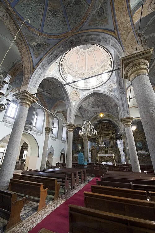 Saint Gregory the Illuminator Church Attraction, Melikgazi13 km SE
-
Mahrumlar Tepesi Mountain, Melikgazi9.7 km SE
-
Yılanlı Dağı Mountain, Melikgazi10 km S
-
Ambar Suyu River, Kayseri Province8.3 km SW
-
Büyükkanisivrisi Tepesi Mountain, Kocasinan11 km NE
Sources & licences
Data last updated: