- Population
- 2,296,347
- 2.3M
- Elevation
- 1,224 m
- above sea level
- Local time
- UTC+03:00
- Europe/Istanbul · UTC+03:00
- Places inside
- 295
- listed under Konya Province
- Airports
- KYA Konya Airport22 km
- NAV Nevşehir Kapadokya Airport190 km
About Konya Province
Konya Province is a region. Location: Turkey. Population: 2,296,347.
Konya Province (Turkish: Konya ili) is a province and metropolitan municipality in southwest Central Anatolia, Turkey. Its area is 40,838 km2, making it the largest province by area, and its population is 2,296,347 (2022). The provincial capital is the city of Konya. Its traffic code is 42. The Kızılören solar power plant in Konya will be able to produce 22.5 megawatts of electricity over an area of 430,000 square meters.
Source: Wikipedia · CC BY-SA 4.0
Photos of Konya Province
-
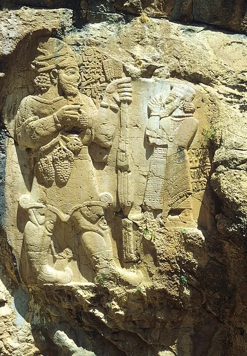
İvriz Harabesi Klaus-Peter Simon · CC BY 3.0

Places bordering Konya Province
- Ankara Province
- Aksaray Province
- Niğde Province
- Mersin Province
- Karaman Province
- Antalya Province
- Afyonkarahisar Province
- Isparta Province
- Eskişehir Province
Population of Konya Province over time
| 2018 | 2,205,609 | |
|---|---|---|
| 2021 | 2,076,524 | |
| 2022 | 2,296,347 |
Censuses and official estimates; source: Wikidata.
Climate of Konya Province
Best months for sightseeingBest months for sightseeing: May–June, September.
This month · November
A cold month
Day 11° · Night -1° · Rain 43 mm
Better nearby cities in November
- Alanya · 186 km south21°
- Silifke · 236 km southeast21°
- Mersin · 241 km southeast22°
- Hottest month
- July (day 29°)
- Coldest month
- January (night -6°)
- Wettest month
- April (55 mm)
- Driest month
- August (5 mm)
Bars: average monthly low and high temperature. Below: precipitation. Monthly averages for 1970–2000 at about 18 km resolution, adjusted for elevation. Highlighted months are mild and relatively dry. Source: WorldClim 2.1 (CC BY 4.0).
Show values as a table
| Month | Jan | Feb | Mar | Apr | May | Jun | Jul | Aug | Sep | Oct | Nov | Dec |
|---|---|---|---|---|---|---|---|---|---|---|---|---|
| Average high (°C) | 2° | 5° | 10° | 15° | 20° | 25° | 29° | 28° | 25° | 18° | 11° | 5° |
| Average low (°C) | -6° | -5° | -2° | 2° | 6° | 9° | 12° | 11° | 7° | 3° | -1° | -4° |
| Precipitation (mm) | 53 | 45 | 48 | 55 | 50 | 22 | 6 | 5 | 11 | 30 | 43 | 53 |
How to get to Konya Province
The nearest airport is Konya Airport (KYA), 22 km to the south as the crow flies. The nearest large city is Konya, 33 km to the south.
Airports
- Konya Airport (KYA) Konya 22 kmsouth
- Nevşehir Kapadokya Airport (NAV) Nevşehir 190 kmeast
- Süleyman Demirel International Airport (ISE) Isparta 190 kmwest
Nearby large cities
- Konya Population: 1.4M 33 kmsouth
- Karaman Population: 175.4K 126 kmsoutheast
- Aksaray Population: 327.6K 135 kmeast
- Heraclea Population: 156.3K 154 kmsoutheast
- Isparta Population: 172.3K 177 kmwest
Straight-line distances; road distances are longer. Airport data: OurAirports.
Places in Konya Province
295 places- 1 Konya 1.4M
- 2 Selcuklu 690.7K
- 3 Meram İlçesi 334K
- 4 Karatay 286.4K
- 5 Ereğli İlçesi 137.8K
- 6 Akşehir İlçesi 93.9K
- 7 Beyşehir İlçesi 70.3K
- 8 Çumra İlçesi 64.6K
- 9 Seydişehir İlçesi 63.6K
- 10 Ilgın İlçesi 56.5K
- 11 Cihanbeyli District 56.2K
- 12 Kulu İlçesi 51.3K
- 13 Karapınar İlçesi 48.7K
- 14 Kadınhanı İlçesi 33.4K
- 15 Bozkır İlçesi 28.2K
- 16 Sarayönü İlçesi 27.1K
- 17 Yunak İlçesi 24.9K
- 18 Doğanhisar İlçesi 18.2K
- 19 Hüyük İlçesi 16.8K
- 20 Altınekin İlçesi 14.5K
- 21 Hadim İlçesi 13.6K
- 22 Çeltik İlçesi 10.4K
- 23 Güneysınır İlçesi 9.9K
- 24 Emirgazi İlçesi 9.3K
- 25 Derebucak İlçesi 7.6K
- 26 Tuzlukçu İlçesi 7.1K
- 27 Taşkent İlçesi 7.1K
- 28 Akören İlçesi 6.7K
- 29 Derbent İlçesi 4.8K
- 30 Ahırlı İlçesi 4.8K
- 31 Halkapınar İlçesi 4.7K
- 32 Yalıhüyük İlçesi 1.8K
Bar: population relative to the most populous place in this list.
Cities & villages8
- Ahırlı Bucağı · Municipality
- Akören Bucağı · Municipality
- Akşehir Bucağı · Municipality
- Altınekin Bucağı · Municipality
- Argıthanı Bucağı · Municipality
- Aşağıçiğil Bucağı · Municipality
- Aşağı Kızilca · Village
- Aşağıpınarbaşı Bucağı · Municipality
Mountains & nature6
- Abdurrahman Çeşmesi · Natural site
- Acı Pınar · Natural site
- Ak Dağ · Mountain
- Ali Pınarı · Natural site
- Ardıç Tepe · Mountain
- Asar Tepesi · Mountain
Lakes, rivers & coasts14
- Acıgöl · Lake
- Adacık · Island
- Adıyan Çayı · River
- Afşar Deresi · River
- Ağılözü Deresi · River
- Akburun Adası · Island
- Akşehir Çayı · River
- Akyay Gölü · Lake
- Alhan Dere · River
- Arpanlıözü Deresi · River
- Aşın Dere · River
- Aydınkent Çayı · River
- Aydınkent Dere · River
- Aygır Adası · Island
Largest cities and towns

Nature and heritage in Konya Province
Sources & licences
Data last updated: · 2 independent sources