- Elevation
- 12 m
- above sea level
- Local time
- UTC+03:00
- Europe/Istanbul · UTC+03:00
- Airports
- COV Çukurova International Airport75 km
- ECN Ercan International Airport177 km
About Erdemli Bucağı
Erdemli Bucağı is a municipality. Location: Mersin Province, Turkey. Elevation: 12 m. The best months to visit are April–May, October–November. The nearest airport is Çukurova International Airport (75 km). Nearby sights include Alata Deresi and Kaplanca Deresi.
Climate of Erdemli Bucağı
Best months for sightseeingBest months for sightseeing: April–May, October–November.
This month · November
A good month to visit
Day 21° · Night 12° · Rain 83 mm
- Hottest month
- August (day 33°)
- Coldest month
- January (night 6°)
- Wettest month
- December (145 mm)
- Driest month
- August (3 mm)
Bars: average monthly low and high temperature. Below: precipitation. Monthly averages for 1970–2000 at about 18 km resolution, adjusted for elevation. Highlighted months are mild and relatively dry. Source: WorldClim 2.1 (CC BY 4.0).
Show values as a table
| Month | Jan | Feb | Mar | Apr | May | Jun | Jul | Aug | Sep | Oct | Nov | Dec |
|---|---|---|---|---|---|---|---|---|---|---|---|---|
| Average high (°C) | 14° | 15° | 18° | 22° | 26° | 30° | 32° | 33° | 31° | 27° | 21° | 16° |
| Average low (°C) | 6° | 7° | 9° | 13° | 16° | 21° | 23° | 23° | 20° | 16° | 12° | 8° |
| Precipitation (mm) | 127 | 95 | 70 | 43 | 30 | 13 | 8 | 3 | 9 | 49 | 83 | 145 |
Other places to visit in this season: April May October November
How to get to Erdemli Bucağı
The nearest airport is Çukurova International Airport (COV), 75 km to the northeast as the crow flies. The nearest large city is Mersin, 37 km to the northeast.
Airports
- Çukurova International Airport (COV) Tarsus 75 kmnortheast
- Ercan International Airport (ECN) Tymbou (Kirklar) 177 kmsouthwest
- Hatay Airport (HTY) Antakya 179 kmeast
Nearby large cities
- Mersin Population: 537.8K 37 kmnortheast
- Silifke Population: 132.7K 42 kmsouthwest
- Tarsus Population: 350.7K 63 kmnortheast
- Adana Population: 1.8M 100 kmnortheast
- Heraclea Population: 156.3K 103 kmnorth
Straight-line distances; road distances are longer. Airport data: OurAirports.
Day trips from Erdemli Bucağı
Within 100 km: 32 historic and cultural sites, 487 natural sites, 147 lakes, rivers and coasts.
0–25 km26 places
- Sandal Dağı Mountain 15 kmW
- Aydoğmuş Tepe Mountain 23 kmNE
- Kapıtaşı Tepesi Mountain 21 kmSW
- Akkum Limanı Natural site 23 kmSW
25–60 km114 places
- Boğsak Adası Island 57 kmSW
- Paradeniz Gölü Lake 45 kmSW
- Dipsiz Göl Lake 56 kmE
- Ak Göl Lake 47 kmSW
60–100 km526 places
- Ovacık Adası Island 74 kmSW
- Dana Adası Island 67 kmSW
- Babadil Adası Island 88 kmSW
- Küçük Ada Island 99 kmE
Straight-line distances.
Nearby attractions & nature
Everything nearby-
Alata Deresi River, Mersin Province1 km E
-
Kaplanca Deresi River, Mersin Province3.2 km NE
-
Limonlu Çayı River, Mersin Province4.5 km SW
-
Lake Karakız River, Mersin Province8.3 km NE
-
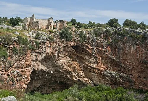 Kanlıdivane Historic site, Erdemli İlçesi15 km SW
-
Halkalı Sarnıcı Natural site, Mersin Province13 km NW
-
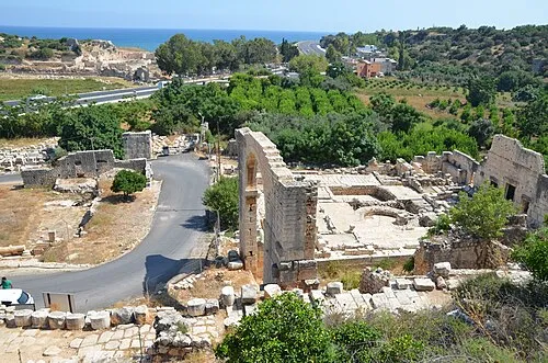 Elaiussa Sebaste Historic site, Erdemli İlçesi18 km SW
-
Akkale Historic site, Erdemli İlçesi11 km SW
Other cities and towns in Mersin Province
Sources & licences
Data last updated: