- Elevation
- 886 m
- above sea level
- Local time
- UTC+03:00
- Europe/Istanbul · UTC+03:00
- Airports
- COV Çukurova International Airport95 km
- GZP Gazipaşa-Alanya Airport163 km
About Kara Dağ
Kara Dağ is a mountain. Location: Silifke İlçesi, Mersin Province. Elevation: 886 m. The best months to visit are May–June, September–October. The nearest airport is Çukurova International Airport (95 km). Nearby sights include Kızılgeçitçayı Deresi and Sandal Dağı.
Climate of Kara Dağ
Best months for sightseeingBest months for sightseeing: May–June, September–October.
This month · November
Outside the best season
Day 16° · Night 5° · Rain 77 mm
Better nearby cities in November
- Silifke · 25 km southwest21°
- Mersin · 56 km northeast22°
- Tarsus · 82 km northeast22°
- Hottest month
- August (day 30°)
- Coldest month
- January (night 0°)
- Wettest month
- December (133 mm)
- Driest month
- August (4 mm)
Bars: average monthly low and high temperature. Below: precipitation. Monthly averages for 1970–2000 at about 18 km resolution, adjusted for elevation. Highlighted months are mild and relatively dry. Source: WorldClim 2.1 (CC BY 4.0).
Show values as a table
| Month | Jan | Feb | Mar | Apr | May | Jun | Jul | Aug | Sep | Oct | Nov | Dec |
|---|---|---|---|---|---|---|---|---|---|---|---|---|
| Average high (°C) | 8° | 10° | 13° | 18° | 22° | 26° | 29° | 30° | 27° | 22° | 16° | 10° |
| Average low (°C) | 0° | 0° | 3° | 7° | 11° | 15° | 18° | 17° | 14° | 10° | 5° | 2° |
| Precipitation (mm) | 125 | 97 | 78 | 51 | 40 | 16 | 7 | 4 | 11 | 47 | 77 | 133 |
Other places to visit in this season: May June September October
How to get to Kara Dağ
The nearest airport is Çukurova International Airport (COV), 95 km to the northeast as the crow flies. The nearest large city is Silifke, 25 km to the southwest.
Airports
- Çukurova International Airport (COV) Tarsus 95 kmnortheast
- Gazipaşa-Alanya Airport (GZP) Gazipaşa 163 kmwest
- Ercan International Airport (ECN) Tymbou (Kirklar) 165 kmsouth
Nearby large cities
- Silifke Population: 132.7K 25 kmsouthwest
- Mersin Population: 537.8K 57 kmnortheast
- Tarsus Population: 350.7K 82 kmnortheast
- Karaman Population: 175.4K 103 kmnorthwest
- Heraclea Population: 156.3K 105 kmnorth
Straight-line distances; road distances are longer. Airport data: OurAirports.
Day trips from Kara Dağ
Within 100 km: 33 historic and cultural sites, 760 natural sites, 163 lakes, rivers and coasts.
0–25 km34 places
- Sandal Dağı Mountain 7 kmNE
- Pusat Dağı Mountain 24 kmW
- Göynük Dağı Mountain 24 kmW
- Dikenalan Tepesi Mountain 18 kmW
25–60 km208 places
- Ovacık Adası Island 58 kmSW
- Dana Adası Island 50 kmSW
- Boğsak Adası Island 40 kmSW
- Paradeniz Gölü Lake 31 kmS
60–100 km714 places
- Babadil Adası Island 70 kmSW
- Aksaz Adası Island 98 kmSW
- Büyük Ada Island 81 kmSW
- Yelkenli Ada Island 80 kmSW
Straight-line distances.
Nearest towns and villages
-
Sömek Village, Silifke İlçesi2.9 km N
-
Esenpınar Village, Erdemli İlçesi3.8 km NE
-
 Hüseyinler Village, Silifke İlçesi4.8 km SW
-
Karaahmetli Village, Erdemli İlçesi4.3 km SE
-
Cambazlı Village, Silifke İlçesi4.9 km W
-
Hacıömerli Village, Erdemli İlçesi2.8 km E
Nearby attractions & nature
Everything nearby-
Kızılgeçitçayı Deresi River, Mersin Province5.1 km N
-
Sandal Dağı Mountain, Erdemli İlçesi6.9 km NE
-
Kapıtaşı Tepesi Mountain, Silifke İlçesi8.3 km S
-
Halkalı Sarnıcı Natural site, Mersin Province13 km NE
-
Akkum Limanı Natural site, Mersin Province13 km S
-
Gökbelen Tepesi Mountain, Silifke İlçesi22 km NW
-
Kokurdan Dağı Mountain, Silifke İlçesi25 km NW
-
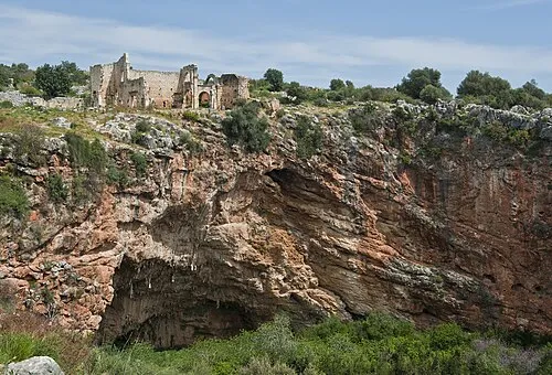 Kanlıdivane Historic site, Erdemli İlçesi9.4 km SE
Sources & licences
Data last updated: · 2 independent sources