Havatarık Tepesi
Located in Gevaş İlçesi, Van Province Coordinates: 38°22′25″ N 42°53′10″ E
- Elevation
- 2,181 m
- above sea level
- Local time
- UTC+03:00
- Europe/Istanbul · UTC+03:00
- Airports
- VAN Van Ferit Melen Airport40 km
- MSR Muş Airport115 km
About Havatarık Tepesi
Havatarık Tepesi is a mountain. Location: Gevaş İlçesi, Van Province. Elevation: 2,181 m. The best months to visit are June–September. The nearest airport is Van Ferit Melen Airport (40 km). Nearby sights include Evegeh Pınarları and Karmravank.
Photos of Havatarık Tepesi
-
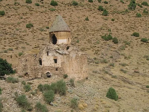
Karmravank Serouj · CC BY-SA 3.0 -
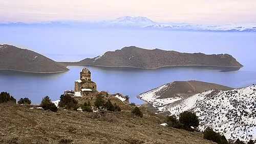
Monastery of Saint Thomas Harunreşits · CC BY-SA 4.0


Climate of Havatarık Tepesi
Best months for sightseeingBest months for sightseeing: June–September.
This month · November
A cold month
Day 6° · Night -1° · Rain 70 mm
Better nearby cities in November
- Silopi · 131 km south20°
- Cizre · 131 km southwest20°
- Kızıltepe · 242 km southwest19°
- Hottest month
- July (day 24°)
- Coldest month
- January (night -8°)
- Wettest month
- April (84 mm)
- Driest month
- July (5 mm)
Bars: average monthly low and high temperature. Below: precipitation. Monthly averages for 1970–2000 at about 18 km resolution, adjusted for elevation. Highlighted months are mild and relatively dry. Source: WorldClim 2.1 (CC BY 4.0).
Show values as a table
| Month | Jan | Feb | Mar | Apr | May | Jun | Jul | Aug | Sep | Oct | Nov | Dec |
|---|---|---|---|---|---|---|---|---|---|---|---|---|
| Average high (°C) | -2° | -1° | 2° | 8° | 13° | 19° | 24° | 24° | 20° | 13° | 6° | 1° |
| Average low (°C) | -8° | -8° | -5° | 1° | 5° | 9° | 13° | 13° | 9° | 4° | -1° | -5° |
| Precipitation (mm) | 54 | 63 | 73 | 84 | 66 | 23 | 5 | 5 | 12 | 61 | 70 | 59 |
Other places to visit in this season: June July August September
How to get to Havatarık Tepesi
The nearest airport is Van Ferit Melen Airport (VAN), 40 km to the east as the crow flies. The nearest large city is Van, 45 km to the east.
Airports
- Van Ferit Melen Airport (VAN) Van 40 kmeast
- Muş Airport (MSR) Muş 115 kmwest
- Şırnak Şerafettin Elçi Airport (NKT) Şırnak 134 kmsouthwest
Nearby large cities
- Van Population: 525K 45 kmeast
- Siirt Population: 114K 96 kmsouthwest
- Silopi Population: 114.6K 131 kmsouth
- Cizre Population: 134K 131 kmsouthwest
- Ağrı Population: 124.5K 149 kmnorth
Straight-line distances; road distances are longer. Airport data: OurAirports.
Day trips from Havatarık Tepesi
Within 100 km: 48 historic and cultural sites, 673 natural sites, 383 lakes, rivers and coasts.
0–25 km62 places
- Akdamar Adası Island 14 kmE
- Kuzu Adası Island 9 kmE
- Avdu Adaları Island 8 kmNE
- Simhaç Adası Island 24 kmNW
25–60 km262 places
- İçeriçarpanak Adası Island 31 kmNE
- Lake Van Lake 28 kmN
- Lake Arin Lake 49 kmN
- Çegen Gölü Lake 56 kmNE
60–100 km780 places
- Yaylagöz Pınar Natural site 82 kmE
- Lim Island Island 68 kmNE
- Turna Gölü Lake 64 kmE
- Lake Nemrut Lake 64 kmNW
Straight-line distances.
Nearest towns and villages
Nearby attractions & nature
Everything nearby-
Evegeh Pınarları Natural site, Van Province1.7 km N
-
Karmravank Attraction, Gevaş İlçesi1.6 km E
-
Monastery of Saint Thomas Attraction, Gevaş İlçesi4.9 km N
-
Yeşilçeşme Pınarı Natural site, Van Province5.7 km NW
-
Mezra Deresi River, Van Province5 km N
-
Satvan Deresi River, Van Province5.3 km SE
-
Büyük Tepe Mountain, Gevaş İlçesi7.4 km N
-
Varlık Körfezi Natural site, Uşak Province6.7 km NE
Sources & licences
Data last updated: