- Elevation
- 767 m
- above sea level
- Local time
- UTC+03:00
- Europe/Istanbul · UTC+03:00
- Airports
- NAV Nevşehir Kapadokya Airport97 km
- ASR Kayseri Erkilet International Airport131 km
About Yerköy Bucağı
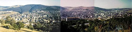
Yerköy Bucağı is a municipality. Location: Yozgat Province, Turkey. Elevation: 767 m. The best months to visit are May, September–October. The nearest airport is Nevşehir Kapadokya Airport (97 km). Nearby sights include Killiközü and Cender Deresi.
Climate of Yerköy Bucağı
Best months for sightseeingBest months for sightseeing: May, September–October.
This month · November
Outside the best season
Day 14° · Night 3° · Rain 37 mm
Better nearby cities in November
- Adana · 305 km south21°
- Tarsus · 305 km south22°
- Mersin · 315 km south22°
- Hottest month
- July (day 31°)
- Coldest month
- January (night -3°)
- Wettest month
- April (45 mm)
- Driest month
- August (8 mm)
Bars: average monthly low and high temperature. Below: precipitation. Monthly averages for 1970–2000 at about 18 km resolution, adjusted for elevation. Highlighted months are mild and relatively dry. Source: WorldClim 2.1 (CC BY 4.0).
Show values as a table
| Month | Jan | Feb | Mar | Apr | May | Jun | Jul | Aug | Sep | Oct | Nov | Dec |
|---|---|---|---|---|---|---|---|---|---|---|---|---|
| Average high (°C) | 5° | 8° | 13° | 19° | 24° | 28° | 31° | 31° | 27° | 21° | 14° | 8° |
| Average low (°C) | -3° | -2° | 2° | 6° | 10° | 13° | 16° | 15° | 12° | 7° | 3° | 0° |
| Precipitation (mm) | 44 | 38 | 40 | 45 | 45 | 35 | 11 | 8 | 17 | 27 | 37 | 45 |
How to get to Yerköy Bucağı
The nearest airport is Nevşehir Kapadokya Airport (NAV), 97 km to the south as the crow flies. The nearest large city is Kırşehir, 61 km to the southwest.
Airports
- Nevşehir Kapadokya Airport (NAV) Nevşehir 97 kmsouth
- Kayseri Erkilet International Airport (ASR) Kayseri 131 kmsoutheast
- Esenboğa International Airport (ESB) Ankara 137 kmnorthwest
Nearby large cities
- Kırşehir Population: 150.7K 61 kmsouthwest
- Kirikkale Population: 187K 86 kmwest
- Çorum Population: 269.6K 109 kmnorth
- Kayseri Population: 1.5M 134 kmsoutheast
- Çankaya Population: 792.2K 141 kmwest
Straight-line distances; road distances are longer. Airport data: OurAirports.
Day trips from Yerköy Bucağı
Within 100 km: 15 historic and cultural sites, 440 natural sites, 162 lakes, rivers and coasts.
0–25 km33 places
- Kırdök Sulama Göleti Lake 23 kmSW
- Orta Dağ Mountain 12 kmSW
- Çiçek Dağı Mountain 23 kmW
- Çatal Tepe Mountain 24 kmN
25–60 km268 places
- Lake Suğla Lake 48 kmS
- Çoğun Barajı Lake 46 kmSW
- Topçu Göleti Lake 32 kmE
- Nigaroğlu Göleti Lake 29 kmNW
60–100 km316 places
- Büklükale Historic site 90 kmW
- Alışar Höyük Historic site 68 kmE
- Hirfanlı Barajı Lake 94 kmSW
- Elekçi Gölü Lake 71 kmN
Straight-line distances.
Nearby attractions & nature
Everything nearby-
Killiközü River, Yozgat Province2.9 km N
-
Cender Deresi River, Yozgat Province2.9 km SE
-
Yozgat Deresi River, Yozgat Province4.6 km SE
-
Toprak Tepesi Mountain, Yerköy İlçesi4.8 km E
-
Bişek Deresi River, Yozgat Province6.8 km NE
-
Büyük Dere River, Yozgat Province9.1 km SE
-
Bişek Deresi River, Yozgat Province9.2 km NW
-
Bozada Tepesi Mountain, Kırşehir Province12 km SE
Other cities and towns in Yozgat Province
-
 Yozgat City, Yozgat35 km NE
-
Şefaatlı City, Şefaatli İlçesi29 km SE
-
Musabeyli Bucağı Municipality, Yozgat Province27 km NE
-
Şefaatlı Bucağı Municipality, Yozgat Province29 km SE
-
Salmanlı Bucağı Municipality, Yozgat Province35 km NW
-
Sorgun City, Sorgun İlçesi64 km E
Sources & licences
Data last updated: