- Elevation
- 1,140 m
- above sea level
- Local time
- UTC+01:00
- Europe/Madrid · UTC+01:00
- Airports
- LEI Almería Airport83 km
- RMU Region of Murcia International Airport112 km
About El Contador
El Contador is a village. Location: Chirivel, Almeria. Elevation: 1,140 m. The best months to visit are May–June, September–October. The nearest airport is Almería Airport (83 km). Nearby sights include Cerro El Roquez and El Malagón.
Photos of El Contador
-
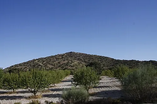
Cerro El Roquez Schumi4ever · CC BY-SA 4.0

Climate of El Contador
Best months for sightseeingBest months for sightseeing: May–June, September–October.
This month · November
Outside the best season
Day 14° · Night 2° · Rain 55 mm
Better nearby cities in November
- Almería · 84 km south20°
- Murcia · 117 km northeast20°
- Cartagena · 121 km east21°
- Hottest month
- July (day 33°)
- Coldest month
- January (night -1°)
- Wettest month
- December (56 mm)
- Driest month
- August (7 mm)
Bars: average monthly low and high temperature. Below: precipitation. Monthly averages for 1970–2000 at about 18 km resolution, adjusted for elevation. Highlighted months are mild and relatively dry. Source: WorldClim 2.1 (CC BY 4.0).
Show values as a table
| Month | Jan | Feb | Mar | Apr | May | Jun | Jul | Aug | Sep | Oct | Nov | Dec |
|---|---|---|---|---|---|---|---|---|---|---|---|---|
| Average high (°C) | 9° | 11° | 14° | 17° | 22° | 28° | 33° | 33° | 27° | 20° | 14° | 10° |
| Average low (°C) | -1° | -1° | 1° | 3° | 7° | 11° | 15° | 15° | 11° | 6° | 2° | 0° |
| Precipitation (mm) | 53 | 47 | 46 | 49 | 45 | 27 | 8 | 7 | 24 | 49 | 55 | 56 |
Other places to visit in this season: May June September October
How to get to El Contador
The nearest airport is Almería Airport (LEI), 83 km to the south as the crow flies. For international flights: Region of Murcia International Airport (RMU) (112 km). The nearest large city is Almería, 84 km to the south.
Airports
- Almería Airport (LEI) Almería 83 kmsouth
- Region of Murcia International Airport (RMU) Corvera 112 kmeast
- F.G.L. Airport Granada-Jaén Airport (GRX) Granada 133 kmwest
Nearby large cities
- Almería Population: 196.9K 84 kmsouth
- Murcia Population: 472K 117 kmnortheast
- Granada Population: 233.5K 119 kmwest
- Cartagena Population: 213.9K 122 kmeast
- Jaén Population: 113.5K 127 kmwest
Straight-line distances; road distances are longer. Airport data: OurAirports.
Day trips from El Contador
Within 100 km: 202 historic and cultural sites, 160 natural sites, 210 lakes, rivers and coasts.
0–25 km19 places
- Perea Mountain 13 kmNW
- Torrecilla Mountain 15 kmW
- Cerro del Taal Mountain 17 kmNW
- Cerro del Muerto Mountain 18 kmN
25–60 km116 places
- Pantano de Valdeinfierno Lake 42 kmNE
- Pantano de Puentes Lake 50 kmE
- Cerro de Alquería Mountain 34 kmE
- Tetica Mountain 38 kmS
60–100 km437 places
- Playa de Carboneras Beach 78 kmSE
- Playa de las Delicias Beach 73 kmE
- Playa de Nueva Almería Beach 86 kmS
- Playa de los muertos Beach 82 kmSE
Straight-line distances.
Nearby attractions & nature
Everything nearby-
Cerro El Roquez Mountain, Chirivel7.1 km E
-
El Malagón Historic site, Cúllar6.4 km SW
-
Sierra de María Mountain, Chirivel14 km NE
-
Cerro Gordo Mountain, Orce12 km NW
-
Perea Mountain, Orce13 km NW
-
Puntal del Morral Mountain, María17 km NE
Sources & licences
Data last updated: