
- Population
- 715
- 715
- Elevation
- 4 m
- above sea level
- Local time
- UTC+01:00
- Europe/Madrid · UTC+01:00
- Airports
- LEI Almería Airport70 km
- RMU Region of Murcia International Airport84 km
About Villaricos
Villaricos is a village. Location: Cuevas del Almanzora, Almeria. Population: 715. Elevation: 4 m.
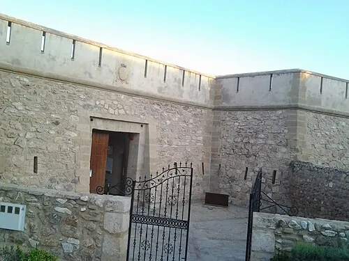
Villaricos is a coastal district located in Cuevas del Almanzora, Spain. On 5 April 1863 the barque Candahar was driven ashore at Villaricos and broke in two. By 2018 it has 626 inhabitants, 335 men and 291 women. Baria, an ancient Punic and later (since 209 BC) Roman city, was found in Villaricos.
Source: Wikipedia · CC BY-SA 4.0
Photos of Villaricos
-

José Guerrero Rodrríguez · CC BY-SA 3.0 -

ANESTRELLA · CC BY-SA 4.0


Climate of Villaricos
Best months for sightseeingBest months for sightseeing: March–May, October–November.
This month · November
A good month to visit
Day 21° · Night 10° · Rain 33 mm
- Hottest month
- August (day 34°)
- Coldest month
- January (night 6°)
- Wettest month
- October (36 mm)
- Driest month
- July (2 mm)
Bars: average monthly low and high temperature. Below: precipitation. Monthly averages for 1970–2000 at about 18 km resolution, adjusted for elevation. Highlighted months are mild and relatively dry. Source: WorldClim 2.1 (CC BY 4.0).
Show values as a table
| Month | Jan | Feb | Mar | Apr | May | Jun | Jul | Aug | Sep | Oct | Nov | Dec |
|---|---|---|---|---|---|---|---|---|---|---|---|---|
| Average high (°C) | 17° | 18° | 20° | 22° | 26° | 30° | 33° | 34° | 31° | 25° | 21° | 17° |
| Average low (°C) | 6° | 7° | 8° | 10° | 13° | 17° | 20° | 20° | 18° | 14° | 10° | 7° |
| Precipitation (mm) | 27 | 24 | 22 | 24 | 22 | 12 | 2 | 3 | 17 | 36 | 33 | 27 |
Other places to visit in this season: March April May October November
How to get to Villaricos
The nearest airport is Almería Airport (LEI), 70 km to the southwest as the crow flies. For international flights: Region of Murcia International Airport (RMU) (84 km). The nearest large city is Almería, 77 km to the southwest.
Airports
- Almería Airport (LEI) Almería 70 kmsouthwest
- Region of Murcia International Airport (RMU) Corvera 84 kmnortheast
- Alicante-Elche Miguel Hernández Airport (ALC) Alicante 156 kmnortheast
Nearby large cities
- Almería Population: 196.9K 77 kmsouthwest
- Cartagena Population: 213.9K 80 kmnortheast
- Murcia Population: 472K 99 kmnortheast
- Orihuela Population: 101.3K 118 kmnortheast
- Elche Population: 234.8K 146 kmnortheast
Straight-line distances; road distances are longer. Airport data: OurAirports.
Day trips from Villaricos
Within 100 km: 235 historic and cultural sites, 142 natural sites, 131 lakes, rivers and coasts.
0–25 km49 places
- Playa de las Delicias Beach 25 kmNE
- Playa de Mojácar Beach 15 kmS
- Playa Macenas Beach 20 kmS
- Playa La Ventanica Beach 18 kmS
25–60 km120 places
- Playa de Carboneras Beach 30 kmS
- Playa de los muertos Beach 35 kmS
- Playa del Peñón Blanco Beach 54 kmSW
- Playa de Agua Amarga Beach 38 kmSW
60–100 km339 places
- Isla Plana Island 61 kmNE
- Playa de las Mulas Beach 95 kmNE
- Playa Larga Beach 98 kmNE
- Playa de Fatares Beach 75 kmNE
Straight-line distances.
Nearby attractions & nature
Everything nearby-
Playa de Luis Siret Beach, Almeria0.7 km SW
-
Almanzora River River, Cuevas del Almanzora1.5 km SW
-
Tenerife Mountain, Cuevas del Almanzora4.5 km NE
-
Sierra Almagrera Mountain, Cuevas del Almanzora4 km NE
-
Playa de Puerto Rey Beach, Vera6.4 km SW
-
 Castillo de las Escobetas Historic site, Garrucha10 km SW
Sources & licences
Data last updated: · 2 independent sources