Uleila del Campo
Located in Almeria, Andalusia Coordinates: 37°11′41″ N 2°11′13″ W
- Population
- 989
- 989
- Elevation
- 630 m
- above sea level
- Local time
- UTC+01:00
- Europe/Madrid · UTC+01:00
- Places inside
- 1
- listed under Uleila del Campo
About Uleila del Campo
Uleila del Campo is a municipality. Location: Almeria, Andalusia. Population: 989. Elevation: 630 m.
Uleila del Campo is a municipality of Almería province, Spain. The village has a local fiesta, Which takes place every year on the second Saturday of September, to celebrate the religious figure, Nuestra Señora de Monteagud. ADSL Internet access in the village has been available since October 2006.
Read more on Wikipedia Text: Wikipedia contributors · CC BY-SA 4.0 · shortened
At a glance
- Area
- 39 km²
Source: Wikidata
In comparison
- No. 54 of 103 places in Almeria by population
- Nearest larger town: Lubrín, 11 km E
Climate of Uleila del Campo
Best months for sightseeing: April–May, October.
| Month | Jan | Feb | Mar | Apr | May | Jun | Jul | Aug | Sep | Oct | Nov | Dec |
|---|---|---|---|---|---|---|---|---|---|---|---|---|
| Average high (°C) | 13° | 14° | 17° | 19° | 24° | 29° | 34° | 34° | 29° | 22° | 17° | 13° |
| Average low (°C) | 2° | 3° | 5° | 7° | 10° | 14° | 18° | 18° | 14° | 10° | 6° | 4° |
| Precipitation (mm) | 43 | 37 | 37 | 41 | 36 | 21 | 5 | 6 | 21 | 43 | 45 | 44 |
Monthly averages for 1970–2000 at about 18 km resolution, adjusted for elevation. Highlighted months are mild and relatively dry. Source: WorldClim 2.1 (CC BY 4.0).
Airports nearest to Uleila del Campo
- Almería Airport (LEI) Almería 42 km
- Region of Murcia International Airport (RMU) Corvera 116 km
- F.G.L. Airport Granada-Jaén Airport (GRX) Granada 141 km
Straight-line distance; airports with scheduled flights only. Source: OurAirports (public domain).
Places in Uleila del Campo
1 place-
Uleila de Campo Village953
Nearby attractions & nature
Everything nearby-
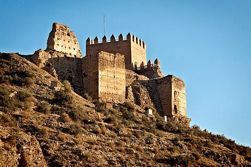 Castillo de Tabernas Historic site, Tabernas24 km SW
-
Centro de Visitantes Los Yesares Museum, Sorbas12 km SE
-
Palacio del Marqués del Carpio Historic site, Sorbas12 km SE
-
Teatro Villaespesa Attraction, Sorbas12 km SE
-
Iglesia Parroquial de Santa María Attraction, Sorbas12 km SE
-
Casa del Duque de Alba Historic site, Sorbas12 km SE
-
Ermita de San Roque Attraction, Sorbas12 km SE
-
Sierra de los Filabres Mountain, Senés13 km W
Sources & licences
Data last updated: · 2 independent sources