- Elevation
- 1,104 m
- above sea level
- Local time
- UTC+01:00
- Europe/Madrid · UTC+01:00
- Airports
- LEI Almería Airport88 km
- RMU Region of Murcia International Airport92 km
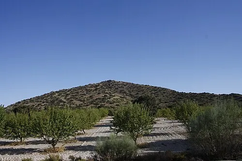
About Cerro de la Monja
Cerro de la Monja is a mountain. Location: Velez Rubio, Almeria. Elevation: 1,104 m. The best months to visit are May–June, September–October. The nearest airport is Almería Airport (88 km). Nearby sights include Cerro de la Atalaya and Puntal del Morral.
Climate of Cerro de la Monja
Best months for sightseeingBest months for sightseeing: May–June, September–October.
This month · November
Outside the best season
Day 14° · Night 2° · Rain 47 mm
Better nearby cities in November
- Almería · 91 km south20°
- Murcia · 98 km northeast20°
- Cartagena · 102 km east21°
- Hottest month
- July (day 33°)
- Coldest month
- January (night -1°)
- Wettest month
- November (47 mm)
- Driest month
- July (7 mm)
Bars: average monthly low and high temperature. Below: precipitation. Monthly averages for 1970–2000 at about 18 km resolution, adjusted for elevation. Highlighted months are mild and relatively dry. Source: WorldClim 2.1 (CC BY 4.0).
Show values as a table
| Month | Jan | Feb | Mar | Apr | May | Jun | Jul | Aug | Sep | Oct | Nov | Dec |
|---|---|---|---|---|---|---|---|---|---|---|---|---|
| Average high (°C) | 10° | 12° | 15° | 17° | 22° | 28° | 33° | 32° | 27° | 20° | 14° | 10° |
| Average low (°C) | -1° | -1° | 1° | 3° | 7° | 11° | 15° | 14° | 11° | 6° | 2° | 0° |
| Precipitation (mm) | 43 | 39 | 39 | 43 | 42 | 25 | 7 | 7 | 23 | 46 | 47 | 45 |
Other places to visit in this season: May June September October
How to get to Cerro de la Monja
The nearest airport is Almería Airport (LEI), 88 km to the south as the crow flies. For international flights: Region of Murcia International Airport (RMU) (92 km). The nearest large city is Almería, 91 km to the south.
Airports
- Almería Airport (LEI) Almería 88 kmsouth
- Region of Murcia International Airport (RMU) Corvera 92 kmeast
- F.G.L. Airport Granada-Jaén Airport (GRX) Granada 153 kmwest
Nearby large cities
- Almería Population: 196.9K 91 kmsouth
- Murcia Population: 472K 98 kmnortheast
- Cartagena Population: 213.9K 102 kmeast
- Orihuela Population: 101.3K 117 kmnortheast
- Granada Population: 233.5K 138 kmwest
Straight-line distances; road distances are longer. Airport data: OurAirports.
Day trips from Cerro de la Monja
Within 100 km: 229 historic and cultural sites, 181 natural sites, 199 lakes, rivers and coasts.
0–25 km21 places
- Cerro de Alquería Mountain 14 kmE
- Cerro Selvarejo Mountain 18 kmE
- Cerro del Muerto Mountain 20 kmNW
- Cerro Montero Mountain 17 kmE
25–60 km146 places
- Playa de las Delicias Beach 56 kmSE
- Playa Mar Rabiosa Beach 51 kmSE
- Playa Calypso Beach 50 kmSE
- Playa la Carolina Beach 53 kmSE
60–100 km442 places
- Isla Plana Island 82 kmE
- Playa de Fatares Beach 98 kmE
- Playa de La Chapineta Beach 85 kmE
- Playa de Carboneras Beach 72 kmS
Straight-line distances.
Nearest towns and villages
-
Velez-Rubio Town, Velez Rubio6.4 km NE
-
La Mata de Bolaimí Village, Velez Rubio3.4 km SE
-
Velez Blanco Village, Velez Blanco9 km NE
-
Los Torrentes Village, Velez Rubio7.8 km E
-
María Village, María10 km N
-
Bancalejo Village, Velez Rubio7.8 km S
Nearby attractions & nature
Everything nearby-
Cerro de la Atalaya Mountain, Velez Rubio3.1 km SW
-
Puntal del Morral Mountain, María10 km NW
-
Sierra de María Mountain, Chirivel10 km NW
-
Iglesia de la Encarnación Attraction, Velez Rubio6.5 km NE
-
Cerro de Gabar Mountain, Velez Blanco17 km N
-
Cerro Reverte Mountain, Lorca17 km E
-
 Cerro El Roquez Mountain, Chirivel14 km SW
-
Peñón de la Chaparra Mountain, Albox12 km S
Sources & licences
Data last updated: