- Elevation
- 445 m
- above sea level
- Local time
- UTC+01:00
- Europe/Madrid · UTC+01:00
- Airports
- ODB Córdoba Airport54 km
- GRX F.G.L. Airport Granada-Jaén Airport67 km
About Ciudad de los Niños
Ciudad de los Niños is a natural site. Location: Cabra, Cordoba. The best months to visit are March–May, October. The nearest airport is Córdoba Airport (54 km). Nearby sights include Mirador de la Paz Park and Castillo de los Condes de Cabra.
Photos of Ciudad de los Niños
-
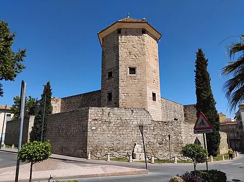
Castillo del Moral CFA1877 · CC BY-SA 4.0

Climate of Ciudad de los Niños
Best months for sightseeingBest months for sightseeing: March–May, October.
This month · November
Outside the best season
Day 18° · Night 7° · Rain 78 mm
Better nearby cities in November
- Málaga · 84 km south20°
- Dos Hermanas · 132 km west20°
- Seville · 135 km west20°
- Hottest month
- July (day 35°)
- Coldest month
- January (night 4°)
- Wettest month
- December (89 mm)
- Driest month
- July (3 mm)
Bars: average monthly low and high temperature. Below: precipitation. Monthly averages for 1970–2000 at about 18 km resolution, adjusted for elevation. Highlighted months are mild and relatively dry. Source: WorldClim 2.1 (CC BY 4.0).
Show values as a table
| Month | Jan | Feb | Mar | Apr | May | Jun | Jul | Aug | Sep | Oct | Nov | Dec |
|---|---|---|---|---|---|---|---|---|---|---|---|---|
| Average high (°C) | 14° | 16° | 19° | 21° | 25° | 30° | 35° | 35° | 30° | 24° | 18° | 15° |
| Average low (°C) | 4° | 5° | 6° | 8° | 11° | 15° | 18° | 18° | 16° | 11° | 7° | 5° |
| Precipitation (mm) | 80 | 61 | 53 | 60 | 43 | 20 | 3 | 5 | 23 | 61 | 78 | 89 |
Other places to visit in this season: March April May October
How to get to Ciudad de los Niños
The nearest airport is Córdoba Airport (ODB), 54 km to the northwest as the crow flies. For international flights: Málaga-Costa del Sol Airport (AGP) (88 km). The nearest large city is Córdoba, 54 km to the northwest.
Airports
- Córdoba Airport (ODB) Córdoba 54 kmnorthwest
- F.G.L. Airport Granada-Jaén Airport (GRX) Granada 67 kmsoutheast
- Málaga-Costa del Sol Airport (AGP) Málaga 88 kmsouth
Nearby large cities
- Córdoba Population: 325.7K 54 kmnorthwest
- Jaén Population: 113.5K 67 kmnortheast
- Granada Population: 233.5K 81 kmsoutheast
- Málaga Population: 592.3K 84 kmsouth
- Marbella Population: 156.3K 113 kmsouth
Straight-line distances; road distances are longer. Airport data: OurAirports.
Day trips from Ciudad de los Niños
Within 100 km: 446 historic and cultural sites, 178 natural sites, 466 lakes, rivers and coasts.
0–25 km98 places
- Sierra de Rute Mountain 18 kmSE
- La Sierra Mountain 5 kmE
- Sierra de la Horconera Mountain 19 kmSE
- Sierra de Gaena Mountain 10 kmSE
25–60 km258 places
- Laguna Salada Lake 50 kmSW
- Cerro del Viento Mountain 54 kmNE
- Sierra del Torcal Mountain 57 kmS
- Sierra de Priego Mountain 28 kmE
60–100 km734 places
- Playa de la Caleta Beach 84 kmS
- Laguna Playa Beach 88 kmS
- La Cala el Cañuelo Beach Beach 100 kmSE
- Platja Rincón de la Victoria Beach 86 kmS
Straight-line distances.
Nearest towns and villages
-
Cabra Town, Cabra0.6 km E
-
Lucena Town, Lucena7.9 km SW
-
Lucena Municipality, Cordoba8.7 km SW
-
 Monturque Municipality, Cordoba12 km W
-
Doña Mencía Municipality, Cordoba12 km NE
-
Doña Mencía Town, Doña Mencía12 km NE
Nearby attractions & nature
Everything nearby-
Mirador de la Paz Park Natural site, Cabra0.4 km S
-
Castillo de los Condes de Cabra Historic site, Cabra0.3 km S
-
Iglesia de Nuestra señora de la Asunción y Ángeles Attraction, Cabra0.3 km SE
-
Iglesia de San Juan de Dios Attraction, Cabra0.4 km SE
-
Muralla Medieval Historic site, Cabra0.4 km SE
-
Arroyo del Chorrillo River, Cabra0.5 km SW
-
Museo Arqueológico Municipal de Cabra Museum, Cabra0.5 km E
-
Museo de la Pasión Museum, Cabra0.8 km E
Sources & licences
Data last updated: