- Local time
- UTC+01:00
- Europe/Madrid · UTC+01:00
- Elevation
- 584 m
- above sea level
- Airports
- GRX F.G.L. Airport Granada-Jaén Airport5 km
- AGP Málaga-Costa del Sol Airport90 km
About Instituto de América Centro Damián Bayón
Instituto de América Centro Damián Bayón is a museum. Location: Santa Fe, Granada. The best months to visit are March–May, October. The nearest airport is F.G.L. Airport Granada-Jaén Airport (5 km). Nearby sights include Parroquia de la Encarnación de Santa Fe and Teatro de la Casa de la Cultura de Santa Fe.
Climate of Instituto de América Centro Damián Bayón
Best months for sightseeingBest months for sightseeing: March–May, October.
This month · November
Outside the best season
Day 18° · Night 7° · Rain 51 mm
Better nearby cities in November
- Málaga · 81 km southwest20°
- Almería · 118 km east20°
- Dos Hermanas · 195 km west20°
- Hottest month
- July (day 35°)
- Coldest month
- January (night 3°)
- Wettest month
- December (57 mm)
- Driest month
- July (3 mm)
Bars: average monthly low and high temperature. Below: precipitation. Monthly averages for 1970–2000 at about 18 km resolution, adjusted for elevation. Highlighted months are mild and relatively dry. Source: WorldClim 2.1 (CC BY 4.0).
Show values as a table
| Month | Jan | Feb | Mar | Apr | May | Jun | Jul | Aug | Sep | Oct | Nov | Dec |
|---|---|---|---|---|---|---|---|---|---|---|---|---|
| Average high (°C) | 14° | 16° | 19° | 21° | 25° | 31° | 35° | 35° | 30° | 24° | 18° | 15° |
| Average low (°C) | 3° | 4° | 6° | 8° | 11° | 15° | 17° | 17° | 15° | 10° | 7° | 4° |
| Precipitation (mm) | 52 | 41 | 40 | 43 | 33 | 17 | 3 | 3 | 19 | 44 | 51 | 57 |
Other places to visit in this season: March April May October
How to get to Instituto de América Centro Damián Bayón
The nearest airport is F.G.L. Airport Granada-Jaén Airport (GRX), 5 km to the west as the crow flies. For international flights: Málaga-Costa del Sol Airport (AGP) (90 km). The nearest large city is Granada, 10 km to the east.
Airports
- F.G.L. Airport Granada-Jaén Airport (GRX) Granada 5 kmwest
- Málaga-Costa del Sol Airport (AGP) Málaga 90 kmsouthwest
- Córdoba Airport (ODB) Córdoba 123 kmnorthwest
Nearby large cities
- Granada Population: 233.5K 10 kmeast
- Jaén Population: 113.5K 65 kmnorth
- Málaga Population: 592.3K 81 kmsouthwest
- Almería Population: 196.9K 119 kmeast
- Córdoba Population: 325.7K 121 kmnorthwest
Straight-line distances; road distances are longer. Airport data: OurAirports.
Day trips from Instituto de América Centro Damián Bayón
Within 100 km: 403 historic and cultural sites, 161 natural sites, 350 lakes, rivers and coasts.
0–25 km98 places
- Pantano de Cubillas Lake 11 kmNE
- Sierra Parapanda Mountain 23 kmNW
- Sierra de Cogollos Mountain 20 kmNE
- Loma del Bufón Mountain 17 kmSE
25–60 km336 places
- Playa Granada Beach 54 kmS
- La Cala el Cañuelo Beach Beach 50 kmS
- Playa de Poniente Beach 55 kmS
- Playa Molino Beach 52 kmS
60–100 km480 places
- Playa de la Caleta Beach 80 kmSW
- Playa de San Nicolás Beach 80 kmSE
- Laguna Playa Beach 61 kmSW
- Playa Castell Del Ferro - Sotillo Beach 61 kmSE
Straight-line distances.
Nearby attractions & nature
Everything nearby-
Parroquia de la Encarnación de Santa Fe Attraction, Santa Fe0.1 km W
-
Teatro de la Casa de la Cultura de Santa Fe Attraction, Santa Fe0.5 km S
-
Eventos Coliseo Landmark, Atarfe4.1 km N
-
Cullar Vega Mediumwave Transmitter Landmark, Cúllar Vega4.3 km SE
-
Parroquia de la Encarnación Attraction, Atarfe4.5 km NE
-
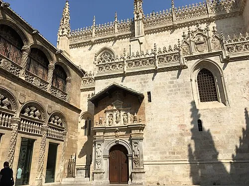 Royal Chapel of Granada Attraction, Granada11 km E
-
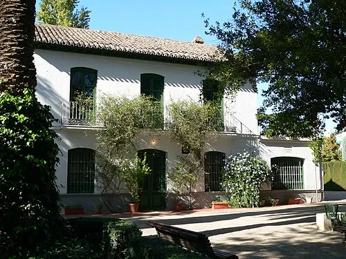 Huerta de San Vicente Museum, Granada9.9 km E
-
Pink Floyd park Natural site, Atarfe3.9 km NE
Nearest towns and villages
-
Santafé Town, Santa Fe0.1 km SW
-
 El Jau Village, Santa Fe2.2 km W
-
 Vegas del Genil Municipality, Granada3.4 km SE
-
 Belicena Village, Vegas del Genil3.1 km SE
Sources & licences
Data last updated: