- Elevation
- 14 m
- above sea level
- Local time
- UTC+01:00
- Europe/Madrid · UTC+01:00
- Airports
- SVQ Seville Airport18 km
- XRY Jerez Airport94 km
About Pelagatos
Pelagatos is a village. Location: Villaverde del Río, Seville. Elevation: 14 m. The best months to visit are March–May, October–November. The nearest airport is Seville Airport (18 km). Nearby sights include Río Viar and Arroyo de Siete Arroyos.
Climate of Pelagatos
Best months for sightseeingBest months for sightseeing: March–May, October–November.
This month · November
A good month to visit
Day 20° · Night 9° · Rain 82 mm
- Hottest month
- July (day 35°)
- Coldest month
- January (night 6°)
- Wettest month
- December (94 mm)
- Driest month
- July (2 mm)
Bars: average monthly low and high temperature. Below: precipitation. Monthly averages for 1970–2000 at about 18 km resolution, adjusted for elevation. Highlighted months are mild and relatively dry. Source: WorldClim 2.1 (CC BY 4.0).
Show values as a table
| Month | Jan | Feb | Mar | Apr | May | Jun | Jul | Aug | Sep | Oct | Nov | Dec |
|---|---|---|---|---|---|---|---|---|---|---|---|---|
| Average high (°C) | 16° | 18° | 21° | 23° | 26° | 31° | 35° | 34° | 31° | 25° | 20° | 16° |
| Average low (°C) | 6° | 7° | 8° | 10° | 13° | 17° | 19° | 19° | 17° | 13° | 9° | 7° |
| Precipitation (mm) | 75 | 54 | 39 | 56 | 34 | 16 | 2 | 5 | 21 | 62 | 82 | 94 |
Other places to visit in this season: March April May October November
How to get to Pelagatos
The nearest airport is Seville Airport (SVQ), 18 km to the south as the crow flies. The nearest large city is Seville, 24 km to the south.
Airports
- Seville Airport (SVQ) Seville 18 kmsouth
- Jerez Airport (XRY) Jerez de la Frontera 94 kmsouth
- Córdoba Airport (ODB) Córdoba 96 kmeast
Nearby large cities
- Seville Population: 686.7K 24 kmsouth
- Dos Hermanas Population: 122.9K 34 kmsouth
- Huelva Population: 144.3K 100 kmwest
- Jerez de la Frontera Population: 212.9K 102 kmsouth
- Córdoba Population: 325.7K 104 kmeast
Straight-line distances; road distances are longer. Airport data: OurAirports.
Day trips from Pelagatos
Within 100 km: 290 historic and cultural sites, 132 natural sites, 455 lakes, rivers and coasts.
0–25 km136 places
- Isla de la Cartuja Island 22 kmSW
- Embalse del Gergal Lake 15 kmW
- Parque del Alamillo Natural site 21 kmSW
- Jardines de Murillo Natural site 24 kmSW
25–60 km240 places
- Isla Mínima Island 56 kmS
- La Isleta Island 42 kmS
- Pantano del Pintado Lake 47 kmN
- Pantano de la Minilla Lake 28 kmW
60–100 km501 places
- Playa de Castilla Beach 89 kmSW
- Playa de Castilla Beach 100 kmSW
- Playa del Bajo Beach 97 kmSW
- Playa de Mazagón Beach 96 kmSW
Straight-line distances.
Nearby attractions & nature
Everything nearby-
Río Viar River, Spain1.9 km E
-
Arroyo de Siete Arroyos River, Villaverde del Río3.1 km SW
-
Arroyo de la Calderona River, Alcalá del Río6.1 km SW
-
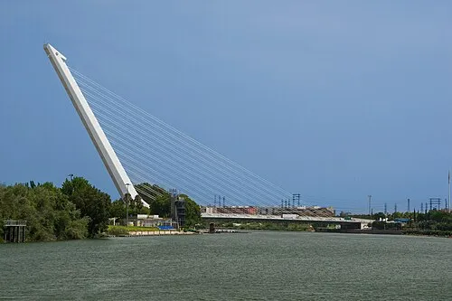 Puente del Alamillo Landmark, Seville21 km SW
-
Arroyo del Trujillo River, Villanueva del Río y Minas9.3 km NE
-
Parque Dehesa Boyal Natural site, Rinconada, La11 km SW
Sources & licences
Data last updated: