Villalba Baja
Located in Teruel Municipality, Province of Teruel Coordinates: 40°25′26″ N 1°04′38″ W

- Population
- 187
- 187
- Elevation
- 951 m
- above sea level
- Local time
- UTC+01:00
- Europe/Madrid · UTC+01:00
- Airports
- CDT Castellón-Costa Azahar Airport101 km
- VLC Valencia Airport116 km
About Villalba Baja
Villalba Baja is a village. Location: Teruel Municipality, Province of Teruel. Population: 187. Elevation: 951 m. The best months to visit are May–June, September–October. The nearest airport is Castellón-Costa Azahar Airport (101 km). Nearby sights include Teruel Cathedral and Rambla de Río Seco.
Photos of Villalba Baja
-

B25es · CC BY-SA 4.0 -

zejijunto · CC BY 3.0 -

zejijunto · CC BY 3.0


Climate of Villalba Baja
Best months for sightseeingBest months for sightseeing: May–June, September–October.
This month · November
Outside the best season
Day 13° · Night 1° · Rain 25 mm
Better nearby cities in November
- Alicante · 237 km south20°
- Elche · 243 km south20°
- Orihuela · 260 km south20°
- Hottest month
- July (day 32°)
- Coldest month
- January (night -2°)
- Wettest month
- May (62 mm)
- Driest month
- February (18 mm)
Bars: average monthly low and high temperature. Below: precipitation. Monthly averages for 1970–2000 at about 18 km resolution, adjusted for elevation. Highlighted months are mild and relatively dry. Source: WorldClim 2.1 (CC BY 4.0).
Show values as a table
| Month | Jan | Feb | Mar | Apr | May | Jun | Jul | Aug | Sep | Oct | Nov | Dec |
|---|---|---|---|---|---|---|---|---|---|---|---|---|
| Average high (°C) | 10° | 12° | 15° | 17° | 21° | 27° | 32° | 31° | 26° | 19° | 13° | 10° |
| Average low (°C) | -2° | -2° | 1° | 3° | 7° | 11° | 13° | 13° | 9° | 6° | 1° | -1° |
| Precipitation (mm) | 22 | 18 | 23 | 40 | 62 | 49 | 30 | 38 | 39 | 45 | 25 | 26 |
Other places to visit in this season: May June September October
How to get to Villalba Baja
The nearest airport is Castellón-Costa Azahar Airport (CDT), 101 km to the east as the crow flies. For international flights: Valencia Airport (VLC) (116 km). The nearest large city is Castellon, 100 km to the southeast.
Airports
- Castellón-Costa Azahar Airport (CDT) Castellón de la Plana 101 kmeast
- Valencia Airport (VLC) Valencia 116 kmsoutheast
- Zaragoza Airport (ZAZ) Zaragoza 138 kmnorth
Nearby large cities
- Castellon Population: 183.7K 100 kmsoutheast
- Valencia Population: 824.3K 121 kmsoutheast
- Zaragoza Population: 687K 138 kmnorth
- Albacete Population: 173K 172 kmsouthwest
- Alcalá de Henares Population: 193.8K 194 kmwest
Straight-line distances; road distances are longer. Airport data: OurAirports.
Day trips from Villalba Baja
Within 100 km: 74 historic and cultural sites, 171 natural sites, 147 lakes, rivers and coasts.
0–25 km26 places
- Monte Castelfrío Mountain 14 kmE
- Sierra de Camarena Mountain 22 kmS
- Rambla de La Hoz River 8 kmSE
- Barranco de la Hoz River 20 kmE
25–60 km107 places
- Laguna de La Encañizada Lake 43 kmNE
- Montes Universales Mountain 45 kmW
- Sierra del Tremedal Mountain 50 kmW
- Sierra de San Just Mountain 45 kmNE
60–100 km259 places
- MeteoLliria Mountain 96 kmSE
- Pantano del Generalísimo Lake 77 kmS
- Pantano de Buceo Lake 92 kmS
- Laguna de Uña Lake 80 kmW
Straight-line distances.
Nearby attractions & nature
Everything nearby-
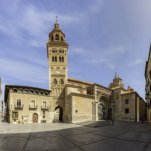 Teruel Cathedral Attraction, Teruel Municipality9.3 km S
-
Rambla de Río Seco River, Teruel Municipality6.6 km S
-
Rambla de La Hoz River, Teruel Municipality7.7 km SE
-
Las Viñas Landmark, Teruel Municipality8.5 km S
-
Acueducto de los Arcos Museum, Teruel Municipality9 km S
-
Museo Histórico Museum, Teruel Municipality9.1 km S
Sources & licences
Data last updated: · 2 independent sources