Valacloche Municipality
Located in Province of Teruel, Aragon Coordinates: 40°10′58″ N 1°04′51″ W
- Population
- 33
- 33
- Elevation
- 1,050 m
- above sea level
- Local time
- UTC+01:00
- Europe/Madrid · UTC+01:00
- Places inside
- 1
- listed under Valacloche Municipality
- Airports
- VLC Valencia Airport93 km
- CDT Castellón-Costa Azahar Airport98 km
About Valacloche Municipality
Valacloche Municipality is a municipality. Location: Province of Teruel, Aragon. Population: 33. Elevation: 1,050 m. The best months to visit are May–June, September–October. The nearest airport is Valencia Airport (93 km). Nearby sights include Fuente del Perdigón and Fuente del Cubillo.
Climate of Valacloche Municipality
Best months for sightseeingBest months for sightseeing: May–June, September–October.
This month · November
Outside the best season
Day 13° · Night 1° · Rain 27 mm
Better nearby cities in November
- Alicante · 211 km south20°
- Elche · 216 km south20°
- Orihuela · 234 km south20°
- Hottest month
- July (day 31°)
- Coldest month
- January (night -3°)
- Wettest month
- May (60 mm)
- Driest month
- February (19 mm)
Bars: average monthly low and high temperature. Below: precipitation. Monthly averages for 1970–2000 at about 18 km resolution, adjusted for elevation. Highlighted months are mild and relatively dry. Source: WorldClim 2.1 (CC BY 4.0).
Show values as a table
| Month | Jan | Feb | Mar | Apr | May | Jun | Jul | Aug | Sep | Oct | Nov | Dec |
|---|---|---|---|---|---|---|---|---|---|---|---|---|
| Average high (°C) | 9° | 11° | 14° | 16° | 21° | 26° | 31° | 30° | 25° | 19° | 13° | 9° |
| Average low (°C) | -3° | -2° | 0° | 2° | 6° | 10° | 13° | 13° | 9° | 5° | 1° | -2° |
| Precipitation (mm) | 23 | 19 | 24 | 42 | 60 | 47 | 29 | 37 | 38 | 46 | 27 | 27 |
Other places to visit in this season: May June September October
How to get to Valacloche Municipality
The nearest airport is Valencia Airport (VLC), 93 km to the southeast as the crow flies. The nearest large city is Castellon, 91 km to the east.
Airports
- Valencia Airport (VLC) Valencia 93 kmsoutheast
- Castellón-Costa Azahar Airport (CDT) Castellón de la Plana 98 kmeast
- Zaragoza Airport (ZAZ) Zaragoza 165 kmnorth
Nearby large cities
- Castellon Population: 183.7K 91 kmeast
- Valencia Population: 824.3K 99 kmsoutheast
- Albacete Population: 173K 148 kmsouthwest
- Zaragoza Population: 687K 165 kmnorth
- Alcalá de Henares Population: 193.8K 197 kmwest
Straight-line distances; road distances are longer. Airport data: OurAirports.
Day trips from Valacloche Municipality
Within 100 km: 209 historic and cultural sites, 221 natural sites, 164 lakes, rivers and coasts.
0–25 km46 places
- Sierra de Javalambre Mountain 11 kmSE
- Sierra de Camarena Mountain 7 kmNE
- Cerro Calderón Mountain 12 kmS
- Fuente de la Zarza Natural site 10 kmE
25–60 km88 places
- Pantano del Generalísimo Lake 50 kmS
- Peña Roya Mountain 45 kmSW
- Peña Rubia Mountain 52 kmSW
- Cerro Mortero Mountain 42 kmSW
60–100 km460 places
- MeteoLliria Mountain 73 kmSE
- Costa del Azahar Beaches Beach 99 kmE
- Platja d'Almarda Beach 93 kmSE
- Torreón Beach 100 kmE
Straight-line distances.
Places in Valacloche Municipality
1 placeBar: population relative to the most populous place in this list.
Nearby attractions & nature
Everything nearby-
Fuente del Perdigón Natural site, Camarena de la Sierra Municipality5.5 km S
-
Fuente del Cubillo Natural site, Riodeva Municipality5.7 km S
-
Fuente del Sabinar Natural site, Riodeva Municipality7.9 km SW
-
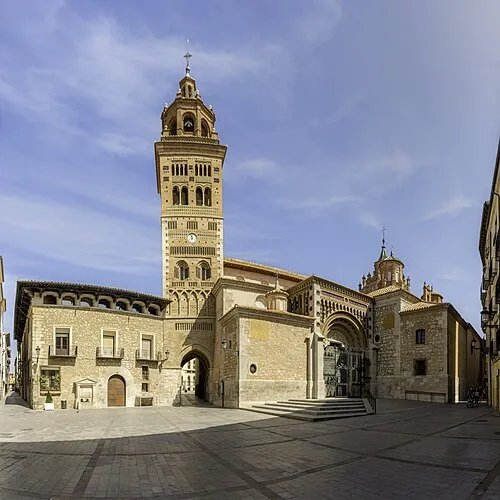 Teruel Cathedral Attraction, Teruel Municipality18 km N
-
Fuente de la Mora Natural site, Villel Municipality8.2 km SW
-
Sierra de Camarena Mountain, Teruel Municipality7.2 km NE
-
Fuente Blanquilla Natural site, Camarena de la Sierra Municipality8.4 km SE
-
Javalambre Mountain, La Puebla de Valverde Municipality11 km SE
Sources & licences
Data last updated: