Roque Palmero
Located in Paso, El, Santa Cruz de Tenerife Coordinates: 28°44′09″ N 17°53′49″ W
- Elevation
- 2,118 m
- above sea level
- Local time
- UTC+00:00
- Atlantic/Canary · UTC+00:00
- Airports
- SPC La Palma Airport18 km
- VDE El Hierro Airport102 km
About Roque Palmero
Roque Palmero is a mountain. Location: Paso, El, Santa Cruz de Tenerife. Elevation: 2,118 m. The best months to visit are June–September. The nearest airport is La Palma Airport (18 km). Nearby sights include Roque de los Muchachos and Roque de los Muchachos.
Photos of Roque Palmero
-
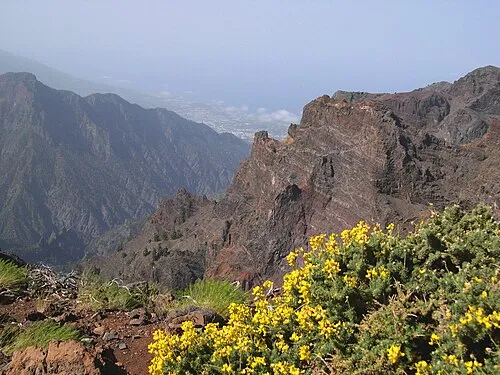
Roque de los Muchachos Wikimedia Commons · CC BY-SA 3.0

Climate of Roque Palmero
Best months for sightseeingBest months for sightseeing: June–September.
This month · November
A cold month
Day 11° · Night 5° · Rain 57 mm
Better nearby cities in November
- Santa Cruz de Tenerife · 163 km east24°
- Las Palmas de Gran Canaria · 253 km east23°
- Telde · 256 km east23°
- Hottest month
- August (day 17°)
- Coldest month
- February (night 2°)
- Wettest month
- December (78 mm)
- Driest month
- July (1 mm)
Bars: average monthly low and high temperature. Below: precipitation. Monthly averages for 1970–2000 at about 18 km resolution, adjusted for elevation. Highlighted months are mild and relatively dry. Source: WorldClim 2.1 (CC BY 4.0).
Show values as a table
| Month | Jan | Feb | Mar | Apr | May | Jun | Jul | Aug | Sep | Oct | Nov | Dec |
|---|---|---|---|---|---|---|---|---|---|---|---|---|
| Average high (°C) | 7° | 8° | 8° | 9° | 11° | 13° | 16° | 17° | 15° | 13° | 11° | 9° |
| Average low (°C) | 3° | 2° | 3° | 3° | 4° | 7° | 9° | 10° | 9° | 7° | 5° | 4° |
| Precipitation (mm) | 74 | 58 | 48 | 28 | 13 | 2 | 1 | 3 | 17 | 41 | 57 | 78 |
Other places to visit in this season: June July August September
How to get to Roque Palmero
The nearest airport is La Palma Airport (SPC), 18 km to the southeast as the crow flies. For international flights: Tenerife Sur Airport (TFS) (151 km). The nearest large city is San Cristóbal de La Laguna, 157 km to the east.
Airports
- La Palma Airport (SPC) Sta Cruz de la Palma, La Palma Island 18 kmsoutheast
- El Hierro Airport (VDE) El Hierro Island 102 kmsouth
- Tenerife Sur Airport (TFS) Tenerife 151 kmsoutheast
Nearby large cities
- San Cristóbal de La Laguna Population: 150.7K 157 kmeast
- Santa Cruz de Tenerife Population: 211.4K 163 kmeast
- Las Palmas de Gran Canaria Population: 383.5K 253 kmeast
- Telde Population: 123.3K 256 kmeast
Straight-line distances; road distances are longer. Airport data: OurAirports.
Day trips from Roque Palmero
Within 100 km: 23 historic and cultural sites, 39 natural sites, 17 lakes, rivers and coasts.
0–25 km54 places
- La Palma Island Island 6 kmSE
- Playa del Camariño Beach 9 kmW
- Playa de Nogales Beach 16 kmE
- Playa Puerto Espindola Beach 15 kmNE
25–60 km3 places
- Teneguía Mountain 30 kmS
- Volcan San Antonio Mountain 28 kmS
- Ermita Nuestra Señora Madre de la Iglesia Attraction 26 kmS
60–100 km22 places
- Alto Garajonay Mountain 90 kmSE
- Bahía de las Calcosas Natural site 100 kmS
- Playa de Vallehermoso Beach 86 kmSE
- Argaga Beach 92 kmSE
Straight-line distances.
Nearest towns and villages
-
Tijarafe Municipality, Santa Cruz de Tenerife6.4 km SW
-
Tijarafe Village, Tijarafe6.5 km SW
-
Puntagorda Municipality, Santa Cruz de Tenerife7.2 km NW
-
Los Llanos de Aridane Town, Llanos de Aridane, Los8.8 km S
-
El Paso Town, Paso, El9.6 km S
-
 Las Tricias Village, Garafía8.4 km NW
Nearby attractions & nature
Everything nearby-
Roque de los Muchachos Mountain, Paso, El2.4 km NE
-
Roque de los Muchachos Mountain, Paso, El2.4 km NE
-
Parque Nacional de la Caldera de Taburiente Natural site, Paso, El3.1 km E
-
Barranco de Las Angustia Natural site, Paso, El4.4 km S
-
Pico Bejenado Mountain, Paso, El5.1 km S
-
La Cumbrecita Mountain, Paso, El6 km SE
-
Pico del Cedro Mountain, Santa Cruz de La Palma6.3 km SE
-
La Palma Island Island, Santa Cruz de Tenerife6.3 km SE
Sources & licences
Data last updated: