- Elevation
- 1,201 m
- above sea level
- Local time
- UTC+01:00
- Europe/Madrid · UTC+01:00
- Airports
- MAD Adolfo Suárez Madrid–Barajas Airport68 km
- VLL Valladolid Airport108 km
About La Salceda
La Salceda is a village. Location: Torre Val de San Pedro, Segovia. Elevation: 1,201 m. The best months to visit are June–September. The nearest airport is Adolfo Suárez Madrid–Barajas Airport (68 km). Nearby sights include Nevera and Arroyo de la Gargantilla.
Climate of La Salceda
Best months for sightseeingBest months for sightseeing: June–September.
This month · November
A cold month
Day 10° · Night 2° · Rain 64 mm
- Hottest month
- July (day 27°)
- Coldest month
- January (night -2°)
- Wettest month
- May (67 mm)
- Driest month
- August (20 mm)
Bars: average monthly low and high temperature. Below: precipitation. Monthly averages for 1970–2000 at about 18 km resolution, adjusted for elevation. Highlighted months are mild and relatively dry. Source: WorldClim 2.1 (CC BY 4.0).
Show values as a table
| Month | Jan | Feb | Mar | Apr | May | Jun | Jul | Aug | Sep | Oct | Nov | Dec |
|---|---|---|---|---|---|---|---|---|---|---|---|---|
| Average high (°C) | 5° | 7° | 11° | 13° | 17° | 22° | 27° | 27° | 22° | 15° | 10° | 6° |
| Average low (°C) | -2° | -1° | 1° | 3° | 6° | 10° | 13° | 13° | 10° | 6° | 2° | -1° |
| Precipitation (mm) | 53 | 43 | 37 | 56 | 67 | 43 | 21 | 20 | 34 | 57 | 64 | 62 |
Other places to visit in this season: June July August September
How to get to La Salceda
The nearest airport is Adolfo Suárez Madrid–Barajas Airport (MAD), 68 km to the southeast as the crow flies. The nearest large city is Alcobendas, 61 km to the south.
Airports
- Adolfo Suárez Madrid–Barajas Airport (MAD) Madrid 68 kmsoutheast
- Valladolid Airport (VLL) Valladolid 108 kmnorthwest
- Salamanca Airport (SLM) Salamanca 136 kmwest
Nearby large cities
- Alcobendas Population: 116K 61 kmsouth
- Chamartin Population: 140K 69 kmsouth
- Ciudad Lineal Population: 228.2K 71 kmsouth
- Madrid Population: 3.3M 73 kmsouth
- Torrejón de Ardoz Population: 118.2K 76 kmsoutheast
Straight-line distances; road distances are longer. Airport data: OurAirports.
Day trips from La Salceda
Within 100 km: 475 historic and cultural sites, 283 natural sites, 375 lakes, rivers and coasts.
0–25 km79 places
- San Millán Attraction 23 kmSW
- Peñacabra Mountain 10 kmS
- Nevera Mountain 9 kmSE
- Navahonda Mountain 12 kmS
25–60 km248 places
- Embalse de Santillana Lake 37 kmS
- Pontón de la Oliva Lake 43 kmSE
- Embalse del Atazar Lake 39 kmSE
- La Jarosa Lake 47 kmSW
60–100 km806 places
- Laguna de Taeña Lake 73 kmSW
- Embalse del Burguillo Lake 91 kmSW
- Pantano de San Juan Lake 84 kmSW
- Pantano de San Juan Lake 84 kmSW
Straight-line distances.
Nearby attractions & nature
Everything nearby-
Nevera Mountain, Torre Val de San Pedro9.5 km SE
-
Arroyo de la Gargantilla River, Basardilla5.3 km SW
-
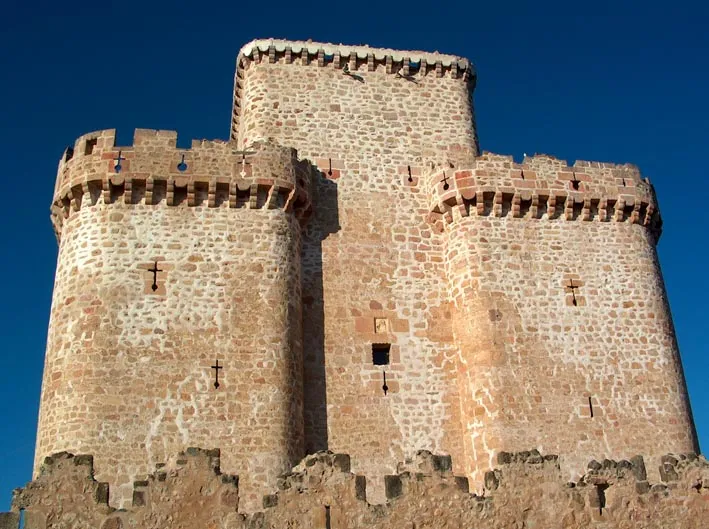 Castle of Turégano Historic site, Turégano15 km NW
-
Arroyo del Chorro River, Torre Val de San Pedro6.4 km SE
-
Río de las Pozas River, Santiuste de Pedraza5.9 km NE
-
Peñacabra Mountain, Pinilla del Valle9.6 km S
Sources & licences
Data last updated: