- Elevation
- 881 m
- above sea level
- Local time
- UTC+01:00
- Europe/Madrid · UTC+01:00
- Airports
- MAD Adolfo Suárez Madrid–Barajas Airport55 km
- VLL Valladolid Airport185 km
About Rebollosa de Hita
Rebollosa de Hita is a village. Location: Torija, Guadalajara. Elevation: 881 m. The best months to visit are May–June, September–October. The nearest airport is Adolfo Suárez Madrid–Barajas Airport (55 km). Nearby sights include Arroyo de Valdepadilla and Arroyo Hantihuela.
Climate of Rebollosa de Hita
Best months for sightseeingBest months for sightseeing: May–June, September–October.
This month · November
Outside the best season
Day 13° · Night 2° · Rain 48 mm
Better nearby cities in November
- Elche · 343 km southeast20°
- Alicante · 347 km southeast20°
- Orihuela · 348 km southeast20°
- Hottest month
- July (day 31°)
- Coldest month
- January (night -1°)
- Wettest month
- October (52 mm)
- Driest month
- July (12 mm)
Bars: average monthly low and high temperature. Below: precipitation. Monthly averages for 1970–2000 at about 18 km resolution, adjusted for elevation. Highlighted months are mild and relatively dry. Source: WorldClim 2.1 (CC BY 4.0).
Show values as a table
| Month | Jan | Feb | Mar | Apr | May | Jun | Jul | Aug | Sep | Oct | Nov | Dec |
|---|---|---|---|---|---|---|---|---|---|---|---|---|
| Average high (°C) | 9° | 11° | 14° | 16° | 20° | 26° | 31° | 30° | 26° | 18° | 13° | 9° |
| Average low (°C) | -1° | 0° | 2° | 4° | 7° | 11° | 14° | 14° | 11° | 7° | 2° | 0° |
| Precipitation (mm) | 35 | 37 | 27 | 40 | 44 | 30 | 12 | 12 | 29 | 52 | 48 | 41 |
Other places to visit in this season: May June September October
How to get to Rebollosa de Hita
The nearest airport is Adolfo Suárez Madrid–Barajas Airport (MAD), 55 km to the southwest as the crow flies. The nearest large city is Alcalá de Henares, 42 km to the southwest.
Airports
- Adolfo Suárez Madrid–Barajas Airport (MAD) Madrid 55 kmsouthwest
- Valladolid Airport (VLL) Valladolid 185 kmnorthwest
- Zaragoza Airport (ZAZ) Zaragoza 195 kmnortheast
Nearby large cities
- Alcalá de Henares Population: 193.8K 42 kmsouthwest
- Torrejón de Ardoz Population: 118.2K 51 kmsouthwest
- Alcobendas Population: 116K 57 kmsouthwest
- Ciudad Lineal Population: 228.2K 63 kmsouthwest
- Chamartin Population: 140K 64 kmsouthwest
Straight-line distances; road distances are longer. Airport data: OurAirports.
Day trips from Rebollosa de Hita
Within 100 km: 433 historic and cultural sites, 322 natural sites, 327 lakes, rivers and coasts.
0–25 km30 places
- Coquin Park Natural site 18 kmSW
- Arroyo Hantihuela River 8 kmN
- Arroyo Grande River 18 kmNW
- Arroyo del Cubo River 15 kmNW
25–60 km272 places
- Pantano de Entrepeñas Lake 36 kmSE
- Pantano de Buendía Lake 47 kmSE
- Pontón de la Oliva Lake 37 kmW
- Embalse del Atazar Lake 41 kmNW
60–100 km780 places
- San Millán Attraction 94 kmW
- Embalse de Santillana Lake 67 kmW
- Laguna de Navahonda Lake 84 kmSE
- Pantano de Monteagudo Lake 99 kmNE
Straight-line distances.
Nearby attractions & nature
Everything nearby-
Arroyo de Valdepadilla River, Hita7 km NW
-
Arroyo Hantihuela River, Hita7.8 km N
-
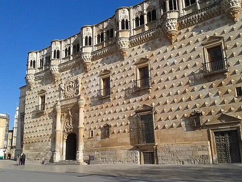 Museo de Guadalajara Museum, Guadalajara19 km SW
-
Río Sorbe River, Alarilla12 km NW
-
Guadalajara Cathedral Attraction, Guadalajara18 km SW
-
Capilla de Don Luis de Lucena Museum, Guadalajara18 km SW
Sources & licences
Data last updated: