Casas de Benítez
Located in Province of Cuenca, Castille-La Mancha Coordinates: 39°18′17″ N 2°06′44″ W
- Population
- 1,018
- 1K
- Elevation
- 735 m
- above sea level
- Local time
- UTC+01:00
- Europe/Madrid · UTC+01:00
- Places inside
- 5
- listed under Casas de Benítez
- Airports
- VLC Valencia Airport142 km
- ALC Alicante-Elche Miguel Hernández Airport176 km
About Casas de Benítez
Casas de Benítez is a municipality. Location: Province of Cuenca, Castille-La Mancha. Population: 1,018. Elevation: 735 m. The best months to visit are May, October. The nearest airport is Valencia Airport (142 km). Nearby sights include Municipal Hondo del Rio Park and Parroquia de Santa María Magdalena.
Climate of Casas de Benítez
Best months for sightseeingBest months for sightseeing: May, October.
This month · November
Outside the best season
Day 14° · Night 4° · Rain 42 mm
Better nearby cities in November
- Elche · 169 km southeast20°
- Orihuela · 169 km southeast20°
- Murcia · 170 km southeast20°
- Hottest month
- July (day 34°)
- Coldest month
- January (night 0°)
- Wettest month
- December (50 mm)
- Driest month
- August (10 mm)
Bars: average monthly low and high temperature. Below: precipitation. Monthly averages for 1970–2000 at about 18 km resolution, adjusted for elevation. Highlighted months are mild and relatively dry. Source: WorldClim 2.1 (CC BY 4.0).
Show values as a table
| Month | Jan | Feb | Mar | Apr | May | Jun | Jul | Aug | Sep | Oct | Nov | Dec |
|---|---|---|---|---|---|---|---|---|---|---|---|---|
| Average high (°C) | 10° | 13° | 16° | 18° | 23° | 29° | 34° | 33° | 28° | 20° | 14° | 11° |
| Average low (°C) | 0° | 1° | 3° | 5° | 9° | 14° | 17° | 17° | 13° | 8° | 4° | 1° |
| Precipitation (mm) | 37 | 33 | 30 | 47 | 46 | 32 | 11 | 10 | 26 | 46 | 42 | 50 |
How to get to Casas de Benítez
The nearest airport is Valencia Airport (VLC), 142 km to the east as the crow flies. The nearest large city is Albacete, 41 km to the southeast.
Airports
- Valencia Airport (VLC) Valencia 142 kmeast
- Alicante-Elche Miguel Hernández Airport (ALC) Alicante 176 kmsoutheast
- Adolfo Suárez Madrid–Barajas Airport (MAD) Madrid 182 kmnorthwest
Nearby large cities
- Albacete Population: 173K 41 kmsoutheast
- Valencia Population: 824.3K 150 kmeast
- Elche Population: 234.8K 169 kmsoutheast
- Alcalá de Henares Population: 193.8K 169 kmnorthwest
- Orihuela Population: 101.3K 169 kmsoutheast
Straight-line distances; road distances are longer. Airport data: OurAirports.
Day trips from Casas de Benítez
Within 100 km: 101 historic and cultural sites, 180 natural sites, 151 lakes, rivers and coasts.
0–25 km16 places
- Cerro Agudo Mountain 23 kmNW
- Cuesta Raimundo Mountain 7 kmE
- Cerro del Chicharrón Mountain 10 kmNE
- Peña Blanca Mountain 24 kmNE
25–60 km119 places
- Laguna Ojos de Villaverde Lake 60 kmS
- Embalse de Alarcón Lake 33 kmN
- Cerro de la Zorra Mountain 59 kmNW
- Cerro de la Zorra Mountain 48 kmNE
60–100 km297 places
- Laguna Tinajas Lake 75 kmSW
- Pantano de Talave Lake 91 kmS
- Laguna San Pedro Lake 75 kmSW
- Laguna del Rey Lake 77 kmSW
Straight-line distances.
Places in Casas de Benítez
5 placesBar: population relative to the most populous place in this list.
Cities & villages2
- La Heredad · Village
- Puente de Don Juan · Village
Heritage & sights1
- Palacio de los Gosálvez · Historic site
Nearby attractions & nature
Everything nearby-
Municipal Hondo del Rio Park Natural site, Villalgordo del Júcar3.9 km E
-
Parroquia de Santa María Magdalena Attraction, Villalgordo del Júcar4.4 km E
-
Cuesta Raimundo Mountain, Villalgordo del Júcar6.9 km E
-
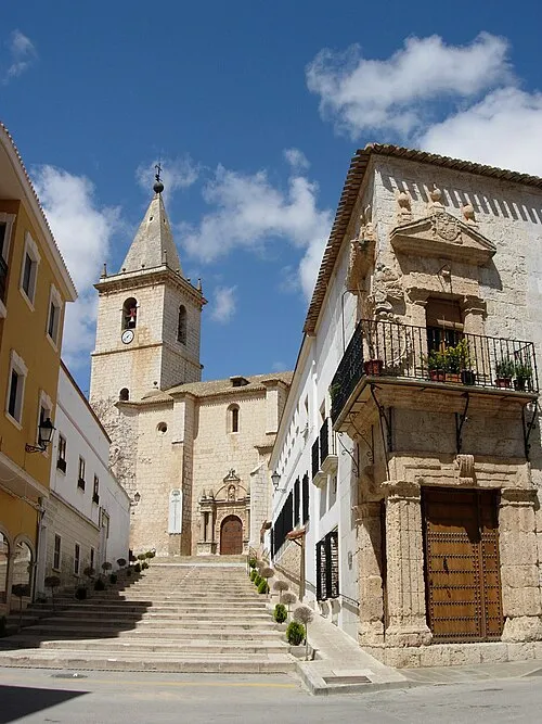 Church of El Salvador o de la Transfiguración Attraction, La Roda12 km S
-
Cerro del Chicharrón Mountain, Alarcón9.6 km NE
-
Casa del Doctor La Encina Historic site, La Roda11 km S
-
Casa de los Atienza Historic site, La Roda12 km S
-
Palacio de La Condesa de Villaleal Historic site, La Roda12 km S
Other cities and towns in Province of Cuenca
-
 Quintanar del Rey Municipality, Province of Cuenca15 km E
-
 Villanueva de la Jara Municipality, Province of Cuenca16 km NE
-
Casas de Haro Municipality, Province of Cuenca13 km W
-
 Vara de Rey Municipality, Province of Cuenca20 km NW
-
Picazo, El Municipality, Province of Cuenca16 km N
-
 Casas de Fernando Alonso Municipality, Province of Cuenca20 km W
Sources & licences
Data last updated: