Fuente del Villar
Located in Cuenca, Province of Cuenca Coordinates: 40°05′06″ N 2°16′41″ W
- Elevation
- 984 m
- above sea level
- Local time
- UTC+01:00
- Europe/Madrid · UTC+01:00
- Airports
- MAD Adolfo Suárez Madrid–Barajas Airport119 km
- VLC Valencia Airport168 km
About Fuente del Villar
Fuente del Villar is a natural site. Location: Cuenca, Province of Cuenca. The best months to visit are May–June, September–October. The nearest airport is Adolfo Suárez Madrid–Barajas Airport (119 km). Nearby sights include Fuente Pinilla and Arroyo de la Parra.
Climate of Fuente del Villar
Best months for sightseeingBest months for sightseeing: May–June, September–October.
This month · November
Outside the best season
Day 13° · Night 3° · Rain 53 mm
Better nearby cities in November
- Elche · 244 km southeast20°
- Alicante · 248 km southeast20°
- Orihuela · 250 km southeast20°
- Hottest month
- July (day 31°)
- Coldest month
- January (night -1°)
- Wettest month
- December (60 mm)
- Driest month
- July (15 mm)
Bars: average monthly low and high temperature. Below: precipitation. Monthly averages for 1970–2000 at about 18 km resolution, adjusted for elevation. Highlighted months are mild and relatively dry. Source: WorldClim 2.1 (CC BY 4.0).
Show values as a table
| Month | Jan | Feb | Mar | Apr | May | Jun | Jul | Aug | Sep | Oct | Nov | Dec |
|---|---|---|---|---|---|---|---|---|---|---|---|---|
| Average high (°C) | 9° | 11° | 14° | 16° | 20° | 26° | 31° | 30° | 26° | 18° | 13° | 10° |
| Average low (°C) | -1° | 0° | 2° | 4° | 8° | 12° | 15° | 15° | 11° | 7° | 3° | 1° |
| Precipitation (mm) | 50 | 42 | 31 | 55 | 59 | 40 | 15 | 16 | 35 | 54 | 53 | 60 |
Other places to visit in this season: May June September October
How to get to Fuente del Villar
The nearest airport is Adolfo Suárez Madrid–Barajas Airport (MAD), 119 km to the northwest as the crow flies. The nearest large city is Alcalá de Henares, 102 km to the northwest.
Airports
- Adolfo Suárez Madrid–Barajas Airport (MAD) Madrid 119 kmnorthwest
- Valencia Airport (VLC) Valencia 168 kmsoutheast
- Castellón-Costa Azahar Airport (CDT) Castellón de la Plana 201 kmeast
Nearby large cities
- Alcalá de Henares Population: 193.8K 102 kmnorthwest
- Torrejón de Ardoz Population: 118.2K 109 kmnorthwest
- Ciudad Lineal Population: 228.2K 123 kmwest
- Chamartin Population: 140K 126 kmwest
- Getafe Population: 187.5K 126 kmwest
Straight-line distances; road distances are longer. Airport data: OurAirports.
Day trips from Fuente del Villar
Within 100 km: 61 historic and cultural sites, 229 natural sites, 186 lakes, rivers and coasts.
0–25 km37 places
- Cerro del Castillo Mountain 18 kmS
- Cerro del Capote Mountain 23 kmN
- Altos de Cabrejas Mountain 19 kmW
- Sierra de Bascuñana Mountain 12 kmNE
25–60 km165 places
- Embalse de Alarcón Lake 55 kmS
- Laguna de Uña Lake 30 kmNE
- Laguna de Navahonda Lake 26 kmW
- Pantano de La Toba Lake 34 kmNE
60–100 km274 places
- Laguna de Manjavacas Lake 90 kmSW
- La Laguna Lake 99 kmSW
- Pantano de Entrepeñas Lake 64 kmNW
- Peña Roya Mountain 89 kmE
Straight-line distances.
Nearest towns and villages
-
Jábaga Village, Fuentenava de Jábaga1.2 km E
-
Fuentenava de Jábaga Municipality, Province of Cuenca4.2 km NW
-
Navalón Village, Fuentenava de Jábaga4.3 km N
-
Chillarón de Cuenca Village, Chillarón de Cuenca5.3 km NE
-
Chillarón de Cuenca Municipality, Province of Cuenca6.6 km NE
-
Cólliga Village, Cuenca4.6 km S
Nearby attractions & nature
Everything nearby-
Fuente Pinilla Natural site, Cuenca1.8 km S
-
Arroyo de la Parra River, Cuenca7.8 km S
-
Río San Martín River, Cuenca8.8 km S
-
Sierra de Bascuñana Mountain, Cuenca12 km NE
-
San Julián Park Natural site, Cuenca12 km E
-
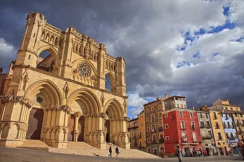 Cuenca Cathedral Attraction, Cuenca13 km E
-
Parque de Los Principes Natural site, Cuenca13 km E
-
Río Huécar River, Cuenca12 km E
Sources & licences
Data last updated: