Garganta de Torinas
Located in Iglesuela, La, Province of Toledo Coordinates: 40°13′54″ N 4°48′06″ W
- Elevation
- 405 m
- above sea level
- Local time
- UTC+01:00
- Europe/Madrid · UTC+01:00
- Airports
- SLM Salamanca Airport100 km
- MAD Adolfo Suárez Madrid–Barajas Airport108 km
About Garganta de Torinas
Garganta de Torinas is a river. Location: Iglesuela, La, Province of Toledo. The best months to visit are May–June, September–October. The nearest airport is Salamanca Airport (100 km). Nearby sights include Arroyo de la Robledosa and Iberian Peninsula.
Climate of Garganta de Torinas
Best months for sightseeingBest months for sightseeing: May–June, September–October.
This month · November
Outside the best season
Day 15° · Night 7° · Rain 42 mm
Better nearby cities in November
- Seville · 333 km south20°
- Dos Hermanas · 342 km south20°
- Málaga · 392 km south20°
- Hottest month
- July (day 32°)
- Coldest month
- January (night 3°)
- Wettest month
- December (44 mm)
- Driest month
- August (10 mm)
Bars: average monthly low and high temperature. Below: precipitation. Monthly averages for 1970–2000 at about 18 km resolution, adjusted for elevation. Highlighted months are mild and relatively dry. Source: WorldClim 2.1 (CC BY 4.0).
Show values as a table
| Month | Jan | Feb | Mar | Apr | May | Jun | Jul | Aug | Sep | Oct | Nov | Dec |
|---|---|---|---|---|---|---|---|---|---|---|---|---|
| Average high (°C) | 11° | 14° | 16° | 18° | 22° | 27° | 32° | 31° | 27° | 21° | 15° | 12° |
| Average low (°C) | 3° | 4° | 6° | 8° | 11° | 15° | 18° | 18° | 15° | 11° | 7° | 4° |
| Precipitation (mm) | 35 | 31 | 26 | 39 | 42 | 30 | 11 | 10 | 25 | 41 | 42 | 44 |
Other places to visit in this season: May June September October
How to get to Garganta de Torinas
The nearest airport is Salamanca Airport (SLM), 100 km to the northwest as the crow flies. For international flights: Adolfo Suárez Madrid–Barajas Airport (MAD) (108 km). The nearest large city is Móstoles, 80 km to the east.
Airports
- Salamanca Airport (SLM) Salamanca 100 kmnorthwest
- Adolfo Suárez Madrid–Barajas Airport (MAD) Madrid 108 kmeast
- Valladolid Airport (VLL) Valladolid 164 kmnorth
Nearby large cities
- Móstoles Population: 207.1K 80 kmeast
- Alcorcón Population: 172.4K 84 kmeast
- Fuenlabrada Population: 190.5K 86 kmeast
- Parla Population: 115.6K 88 kmeast
- Leganés Population: 188.4K 89 kmeast
Straight-line distances; road distances are longer. Airport data: OurAirports.
Day trips from Garganta de Torinas
Within 100 km: 393 historic and cultural sites, 213 natural sites, 274 lakes, rivers and coasts.
0–25 km33 places
- Pelados Mountain 12 kmSE
- Navasolana Mountain 25 kmNW
- Navalasierra Mountain 10 kmS
- Alto del Mirlo Mountain 25 kmNE
25–60 km177 places
- Laguna de Taeña Lake 55 kmN
- Laguna Grande de Gredos Lake 41 kmW
- Embalse del Burguillo Lake 29 kmNE
- Pantano de San Juan Lake 43 kmNE
60–100 km670 places
- San Millán Attraction 98 kmNE
- Embalse de Valdecañas Lake 72 kmSW
- Pantano del Torcón Lake 78 kmSE
- Pantano de Pasarón Lake 91 kmW
Straight-line distances.
Nearest towns and villages
-
 Sartajada Municipality, Province of Toledo1.7 km S
-
Sartajada Village, Sartajada2.1 km S
-
 Mijares Municipality, Avila5 km NW
-
La Iglesuela del Tiétar Village, Iglesuela, La4.3 km E
-
 Gavilanes Municipality, Avila5.9 km NW
-
Almendral de la Cañada Municipality, Province of Toledo6.3 km SE
Nearby attractions & nature
Everything nearby-
Arroyo de la Robledosa River, Mijares1.3 km W
-
Iberian Peninsula Natural site, Avila3.6 km N
-
Garganta de las Torres River, Mijares4.5 km SW
-
Valle del Tiétar Natural site, Spain4.4 km SW
-
Arroyo de la Cerecala River, Iglesuela, La4.8 km NE
-
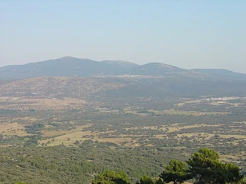 Cruces Mountain, Navamorcuende10 km SE
-
Navalasierra Mountain, Navamorcuende10 km S
-
Río Escorial River, Adrada, La11 km NE
Sources & licences
Data last updated: