Punta de l'Aigua
Located in Horta de Sant Joan, Tarragona Coordinates: 40°55′40″ N 0°22′08″ E
- Elevation
- 1,092 m
- above sea level
- Local time
- UTC+01:00
- Europe/Madrid · UTC+01:00
- Airports
- REU Reus Airport72 km
- CDT Castellón-Costa Azahar Airport83 km
About Punta de l'Aigua
Punta de l'Aigua is a mountain. Location: Horta de Sant Joan, Tarragona. Elevation: 1,092 m. The best months to visit are June–September. The nearest airport is Reus Airport (72 km). Nearby sights include Punta dels Raus and Mola dels Atans.
Photos of Punta de l'Aigua
-
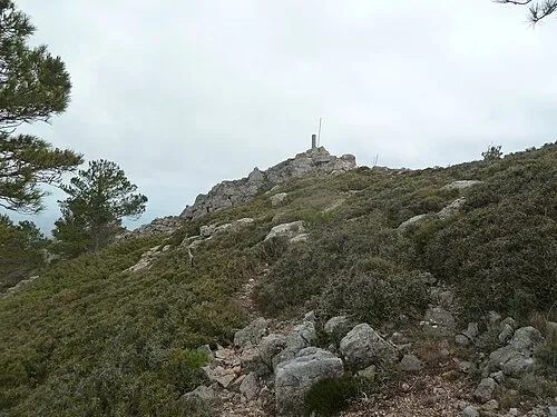
la Coscollosa Caçavertex · CC0

Climate of Punta de l'Aigua
Best months for sightseeingBest months for sightseeing: June–September.
This month · November
A cold month
Day 11° · Night 2° · Rain 56 mm
Better nearby cities in November
- Alicante · 296 km south20°
- Elche · 310 km south20°
- Orihuela · 336 km south20°
- Hottest month
- July (day 25°)
- Coldest month
- January (night -2°)
- Wettest month
- October (66 mm)
- Driest month
- July (15 mm)
Bars: average monthly low and high temperature. Below: precipitation. Monthly averages for 1970–2000 at about 18 km resolution, adjusted for elevation. Highlighted months are mild and relatively dry. Source: WorldClim 2.1 (CC BY 4.0).
Show values as a table
| Month | Jan | Feb | Mar | Apr | May | Jun | Jul | Aug | Sep | Oct | Nov | Dec |
|---|---|---|---|---|---|---|---|---|---|---|---|---|
| Average high (°C) | 7° | 9° | 12° | 13° | 17° | 22° | 25° | 25° | 22° | 16° | 11° | 7° |
| Average low (°C) | -2° | -1° | 0° | 2° | 6° | 9° | 12° | 13° | 10° | 6° | 2° | -1° |
| Precipitation (mm) | 38 | 27 | 36 | 48 | 62 | 41 | 15 | 30 | 56 | 66 | 56 | 51 |
Other places to visit in this season: June July August September
How to get to Punta de l'Aigua
The nearest airport is Reus Airport (REU), 72 km to the east as the crow flies. The nearest large city is Reus, 67 km to the northeast.
Airports
- Reus Airport (REU) Reus 72 kmeast
- Castellón-Costa Azahar Airport (CDT) Castellón de la Plana 83 kmsouth
- Lleida-Alguaire Airport (ILD) Lleida 90 kmnorth
Nearby large cities
- Reus Population: 103.5K 67 kmnortheast
- Tarragona Population: 141.5K 77 kmeast
- Lleida Population: 140.8K 79 kmnorth
- Castellon Population: 183.7K 110 kmsouth
- Zaragoza Population: 687K 132 kmnorthwest
Straight-line distances; road distances are longer. Airport data: OurAirports.
Day trips from Punta de l'Aigua
Within 100 km: 152 historic and cultural sites, 233 natural sites, 174 lakes, rivers and coasts.
0–25 km77 places
- Pantano de La Peña Lake 23 kmSW
- Soláns Mountain 6 kmNW
- Collredó Mountain 21 kmSE
- Sierra Pesells Mountain 11 kmN
25–60 km208 places
- Playa del Río Beach 52 kmS
- Playa de Rifá Beach 53 kmE
- Platja del Marjal Beach 44 kmS
- L'Estanyet Beach 45 kmS
60–100 km274 places
- Playa Roda Beach 75 kmS
- Playa del Rincón Beach 70 kmE
- Playa del Moro Beach 78 kmS
- Playa del Cargador Beach 77 kmS
Straight-line distances.
Nearest towns and villages
-
Paüls Village, Paüls Municipality2.9 km SE
-
Paüls Municipality Municipality, Tarragona3.5 km E
-
Prat de Comte Municipality, Tarragona6.3 km NE
-
Alfara de Carles Village, Alfara de Carles Municipality6.6 km SE
-
Horta de Sant Joan Village, Horta de Sant Joan5 km NW
-
Xerta Municipality Municipality, Tarragona8.4 km E
Nearby attractions & nature
Everything nearby-
Punta dels Raus Mountain, Paüls Municipality0.8 km N
-
Mola dels Atans Mountain, Horta de Sant Joan0.9 km W
-
Punta del Vacarissal Mountain, Horta de Sant Joan1.3 km S
-
Mola Grossa Mountain, Paüls Municipality2.1 km NE
-
Tossal d'Engrilló Mountain, Horta de Sant Joan1.7 km N
-
Moleta de les Canals Mountain, Horta de Sant Joan2.2 km S
-
Mola de Garrí Mountain, Prat de Comte2.6 km NE
-
Punta de l'Esterrossall Mountain, Prat de Comte3.7 km NE
Sources & licences
Data last updated: