- Elevation
- 89 m
- above sea level
- Local time
- UTC+01:00
- Europe/Madrid · UTC+01:00
- Airports
- OVD Asturias Airport79 km
- LCG A Coruña Airport113 km
About Samagán
Samagán is a village. Location: Castropol Municipality, Asturias. Elevation: 89 m. The best months to visit are June–September. The nearest airport is Asturias Airport (79 km). Nearby sights include Eo River and Playa Penarronda.
Climate of Samagán
Best months for sightseeingBest months for sightseeing: June–September.
This month · November
A wet month
Day 16° · Night 9° · Rain 140 mm
- Hottest month
- August (day 25°)
- Coldest month
- January (night 6°)
- Wettest month
- December (149 mm)
- Driest month
- July (40 mm)
Bars: average monthly low and high temperature. Below: precipitation. Monthly averages for 1970–2000 at about 18 km resolution, adjusted for elevation. Highlighted months are mild and relatively dry. Source: WorldClim 2.1 (CC BY 4.0).
Show values as a table
| Month | Jan | Feb | Mar | Apr | May | Jun | Jul | Aug | Sep | Oct | Nov | Dec |
|---|---|---|---|---|---|---|---|---|---|---|---|---|
| Average high (°C) | 13° | 14° | 16° | 17° | 19° | 22° | 24° | 25° | 23° | 20° | 16° | 14° |
| Average low (°C) | 6° | 6° | 7° | 8° | 10° | 13° | 15° | 15° | 13° | 11° | 9° | 7° |
| Precipitation (mm) | 134 | 111 | 94 | 110 | 95 | 55 | 40 | 45 | 80 | 133 | 140 | 149 |
Other places to visit in this season: June July August September
How to get to Samagán
The nearest airport is Asturias Airport (OVD), 79 km to the east as the crow flies. The nearest large city is Oviedo, 94 km to the east.
Airports
- Asturias Airport (OVD) Ranón 79 kmeast
- A Coruña Airport (LCG) Culleredo 113 kmwest
- Santiago-Rosalía de Castro Airport (SCQ) Santiago de Compostela 131 kmsouthwest
Nearby large cities
- Oviedo Population: 220K 94 kmeast
- Gijón Population: 271.8K 109 kmeast
- A Coruña Population: 250.4K 113 kmwest
- Ourense Population: 105.2K 143 kmsouthwest
- León Population: 124.8K 150 kmsoutheast
Straight-line distances; road distances are longer. Airport data: OurAirports.
Day trips from Samagán
Within 100 km: 111 historic and cultural sites, 99 natural sites, 200 lakes, rivers and coasts.
0–25 km37 places
- Playa de Represas Beach 14 kmNE
- Praia de Paixás Beach 25 kmNW
- Praia de Lobás Beach 24 kmNW
- Playa Permenande Beach 19 kmNE
25–60 km112 places
- Playa de Santa Ana Beach 49 kmE
- Playa de Celeiro Beach 54 kmNW
- Playa de Barayo Beach 34 kmE
- Playa de Otur Beach 35 kmE
60–100 km261 places
- Praia de Cariño Beach 77 kmNW
- Playón de Bayas Beach 79 kmE
- Playa de Aguilar Beach 72 kmE
- Playa de San Pedro Beach 65 kmE
Straight-line distances.
Nearby attractions & nature
Everything nearby-
Eo River River, Vegadeo4.7 km NW
-
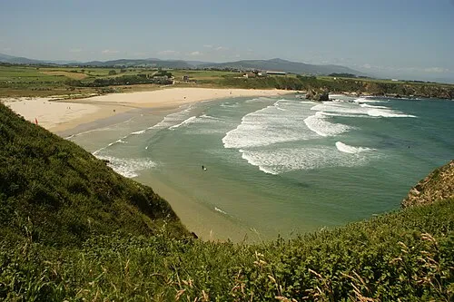 Playa Penarronda Beach, Castropol Municipality11 km N
-
Palacio Marques de Santa Cruz Historic site, Castropol Municipality8.5 km N
-
Parroquia de Santiago Apóstol Attraction, Castropol Municipality8.6 km N
-
Cofradia de pescadores Museum, Castropol Municipality9.4 km N
-
Palacio de Trenor Historic site, Castropol Municipality9.5 km N
Sources & licences
Data last updated: