Playa de Tapia
Located in Asturias, Principality of Asturias Coordinates: 43°34′05″ N 6°57′01″ W
- Local time
- UTC+01:00
- Europe/Madrid · UTC+01:00
- Airports
- OVD Asturias Airport74 km
- LCG A Coruña Airport119 km
About Playa de Tapia
Playa de Tapia is a beach. Location: Asturias, Principality of Asturias. The best months to visit are June–September. The nearest airport is Asturias Airport (74 km). Nearby sights include Cabo Sebes and Playa de Represas.
Photos of Playa de Tapia
-
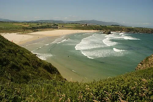
Playa Penarronda Marta Gonzalez · Public domain

Climate of Playa de Tapia
Best months for sightseeingBest months for sightseeing: June–September.
This month · November
A wet month
Day 16° · Night 8° · Rain 128 mm
- Hottest month
- August (day 24°)
- Coldest month
- January (night 6°)
- Wettest month
- December (132 mm)
- Driest month
- July (37 mm)
Bars: average monthly low and high temperature. Below: precipitation. Monthly averages for 1970–2000 at about 18 km resolution, adjusted for elevation. Highlighted months are mild and relatively dry. Source: WorldClim 2.1 (CC BY 4.0).
Show values as a table
| Month | Jan | Feb | Mar | Apr | May | Jun | Jul | Aug | Sep | Oct | Nov | Dec |
|---|---|---|---|---|---|---|---|---|---|---|---|---|
| Average high (°C) | 13° | 14° | 15° | 16° | 18° | 21° | 23° | 24° | 22° | 19° | 16° | 14° |
| Average low (°C) | 6° | 6° | 6° | 7° | 10° | 12° | 14° | 14° | 13° | 11° | 8° | 7° |
| Precipitation (mm) | 118 | 98 | 84 | 101 | 85 | 49 | 37 | 42 | 71 | 123 | 128 | 132 |
Other places to visit in this season: June July August September
How to get to Playa de Tapia
The nearest airport is Asturias Airport (OVD), 74 km to the east as the crow flies. The nearest large city is Oviedo, 92 km to the east.
Airports
- Asturias Airport (OVD) Ranón 74 kmeast
- A Coruña Airport (LCG) Culleredo 119 kmwest
- Santiago-Rosalía de Castro Airport (SCQ) Santiago de Compostela 140 kmsouthwest
Nearby large cities
- Oviedo Population: 220K 92 kmeast
- Gijón Population: 271.8K 104 kmeast
- A Coruña Population: 250.4K 119 kmwest
- León Population: 124.8K 156 kmsoutheast
- Ourense Population: 105.2K 156 kmsouthwest
Straight-line distances; road distances are longer. Airport data: OurAirports.
Day trips from Playa de Tapia
Within 100 km: 106 historic and cultural sites, 87 natural sites, 184 lakes, rivers and coasts.
0–25 km33 places
- Playa de Represas Beach 1 kmE
- Praia de Paixás Beach 24 kmW
- Praia de Lobás Beach 23 kmW
- Playa Permenande Beach 10 kmE
25–60 km106 places
- Playa de Santa Ana Beach 43 kmE
- Playa de San Pedro Beach 59 kmE
- Playa de Celeiro Beach 53 kmW
- Playa de Barayo Beach 27 kmE
60–100 km238 places
- Praia de Cariño Beach 77 kmW
- Playón de Bayas Beach 73 kmE
- Playa de Aguilar Beach 67 kmE
- Playa de los Quebrantos Beach 71 kmE
Straight-line distances.
Nearest towns and villages
-
 Tapia de Casariego Village, Soto del Barco Municipality0.6 km NE
-
Soto del Barco Municipality Municipality, Asturias3.1 km SE
-
El Viso Village, Soto del Barco Municipality0.8 km SE
-
Calambre Village, Soto del Barco Municipality1.5 km S
-
Casariego Village, Soto del Barco Municipality1.8 km S
-
Ventosa Village, Soto del Barco Municipality2.4 km SE
Nearby attractions & nature
Everything nearby-
Cabo Sebes Natural site, Soto del Barco Municipality0.8 km NE
-
Playa de Represas Beach, Soto del Barco Municipality1.4 km E
-
Playa Penarronda Beach, Castropol Municipality4 km SW
-
Las Pantorgas Island, Castropol Municipality3.1 km W
-
Río Porcía River, Franco, El6 km E
-
Ensenada de Porcía Natural site, Franco, El6.8 km E
-
Atalaya Park Natural site, Ribadeo7.8 km SW
-
Cabo Blanco Natural site, Franco, El8.4 km E
Sources & licences
Data last updated: · 2 independent sources