- Elevation
- 367 m
- above sea level
- Local time
- UTC+01:00
- Europe/Madrid · UTC+01:00
- Airports
- VLC Valencia Airport72 km
- ALC Alicante-Elche Miguel Hernández Airport74 km
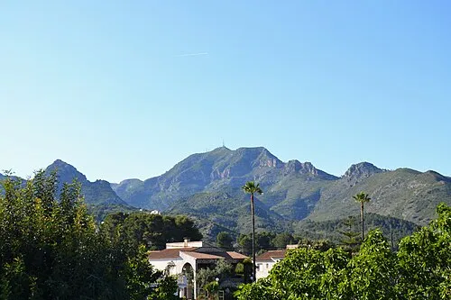
About Sierra de Gallinera
Sierra de Gallinera is a mountain. Location: Adsubia, Alicante. Elevation: 367 m. The best months to visit are April–June, September–October. The nearest airport is Valencia Airport (72 km). Nearby sights include Sierra de Mustalla and Almiserà.
Climate of Sierra de Gallinera
Best months for sightseeingBest months for sightseeing: April–June, September–October.
This month · November
Outside the best season
Day 17° · Night 6° · Rain 38 mm
Better nearby cities in November
- Alicante · 65 km southwest20°
- Elche · 82 km southwest20°
- Orihuela · 110 km southwest20°
- Hottest month
- July (day 31°)
- Coldest month
- January (night 3°)
- Wettest month
- October (54 mm)
- Driest month
- July (9 mm)
Bars: average monthly low and high temperature. Below: precipitation. Monthly averages for 1970–2000 at about 18 km resolution, adjusted for elevation. Highlighted months are mild and relatively dry. Source: WorldClim 2.1 (CC BY 4.0).
Show values as a table
| Month | Jan | Feb | Mar | Apr | May | Jun | Jul | Aug | Sep | Oct | Nov | Dec |
|---|---|---|---|---|---|---|---|---|---|---|---|---|
| Average high (°C) | 13° | 15° | 17° | 19° | 22° | 27° | 31° | 31° | 27° | 22° | 17° | 13° |
| Average low (°C) | 3° | 4° | 5° | 7° | 11° | 15° | 18° | 18° | 15° | 11° | 6° | 4° |
| Precipitation (mm) | 23 | 25 | 27 | 39 | 39 | 25 | 9 | 12 | 38 | 54 | 38 | 33 |
Other places to visit in this season: April May June September October
How to get to Sierra de Gallinera
The nearest airport is Valencia Airport (VLC), 72 km to the north as the crow flies. The nearest large city is Alicante, 65 km to the southwest.
Airports
- Valencia Airport (VLC) Valencia 72 kmnorth
- Alicante-Elche Miguel Hernández Airport (ALC) Alicante 74 kmsouthwest
- Ibiza Airport (IBZ) Ibiza (Eivissa) 135 kmeast
Nearby large cities
- Alicante Population: 348.9K 65 kmsouthwest
- Valencia Population: 824.3K 68 kmnorth
- Elche Population: 234.8K 82 kmsouthwest
- Orihuela Population: 101.3K 110 kmsouthwest
- Castellon Population: 183.7K 123 kmnorth
Straight-line distances; road distances are longer. Airport data: OurAirports.
Day trips from Sierra de Gallinera
Within 100 km: 407 historic and cultural sites, 233 natural sites, 151 lakes, rivers and coasts.
0–25 km70 places
- Playa Nort de Gandía Beach 15 kmN
- Playa De L'Ahuir Beach 15 kmN
- Playa de Piles Beach 10 kmNE
- Playa de Tavernes de la Valldigna Beach 22 kmN
25–60 km286 places
- Platja d'Altea Beach 34 kmS
- Platja de l'Albir Beach 35 kmS
- Playa de Levante Beach 39 kmS
- Playa de Poniente Beach 38 kmS
60–100 km435 places
- MeteoLliria Mountain 92 kmN
- Museo de La Asegurada Museum 65 kmSW
- MUBAG Museum 65 kmSW
- MARQ - Museo Arqueológico Museum 64 kmSW
Straight-line distances.
Nearest towns and villages
-
Villalonga Village, Villalonga Municipality2.4 km W
-
Forna Village, Adsubia1.1 km SE
-
 Villalonga Municipality Municipality, Valencia4 km W
-
Adsubia Village, Adsubia4.2 km SE
-
Font d'En Carròs, la Municipality, Valencia4.6 km NE
-
Potríes Municipality Municipality, Valencia4.2 km N
Nearby attractions & nature
Everything nearby-
Sierra de Mustalla Mountain, Pego5 km E
-
Almiserà Mountain, Vall de Gallinera5.4 km S
-
el Rabat Mountain, Rafelcofer Municipality5.6 km N
-
muntanyeta de Sant Miquel Mountain, Alqueria de la Comtessa, l'6.2 km N
-
la Safor Mountain, Vall de Gallinera7.1 km W
-
Parc Public Hort De La Bosca Natural site, Oliva7.8 km NE
-
la Cuta Mountain, Villalonga Municipality7.9 km W
-
 Mondúver Mountain, Xeresa16 km NW
Sources & licences
Data last updated: