- Elevation
- 46 m
- above sea level
- Local time
- UTC+01:00
- Europe/Madrid · UTC+01:00
- Airports
- RMU Region of Murcia International Airport38 km
- ALC Alicante-Elche Miguel Hernández Airport38 km
About Virgen del Camino
Virgen del Camino is a village. Location: Orihuela, Alicante. Elevation: 46 m. The best months to visit are March–May, October–November. The nearest airport is Region of Murcia International Airport (38 km). Nearby sights include Rambla Redovan and Museo Diocesano de Arte Sacro.
Photos of Virgen del Camino
-
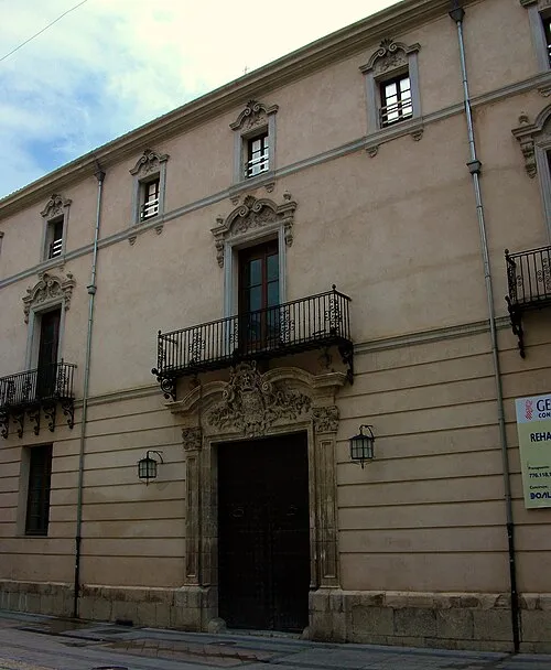
Museo Diocesano de Arte Sacro Joanbanjo · CC BY-SA 3.0

Climate of Virgen del Camino
Best months for sightseeingBest months for sightseeing: March–May, October–November.
This month · November
A good month to visit
Day 20° · Night 10° · Rain 35 mm
- Hottest month
- August (day 32°)
- Coldest month
- January (night 6°)
- Wettest month
- October (47 mm)
- Driest month
- July (5 mm)
Bars: average monthly low and high temperature. Below: precipitation. Monthly averages for 1970–2000 at about 18 km resolution, adjusted for elevation. Highlighted months are mild and relatively dry. Source: WorldClim 2.1 (CC BY 4.0).
Show values as a table
| Month | Jan | Feb | Mar | Apr | May | Jun | Jul | Aug | Sep | Oct | Nov | Dec |
|---|---|---|---|---|---|---|---|---|---|---|---|---|
| Average high (°C) | 16° | 17° | 19° | 22° | 25° | 29° | 32° | 32° | 29° | 24° | 20° | 17° |
| Average low (°C) | 6° | 7° | 8° | 10° | 13° | 18° | 20° | 21° | 18° | 14° | 10° | 7° |
| Precipitation (mm) | 23 | 26 | 28 | 28 | 31 | 17 | 5 | 8 | 29 | 47 | 35 | 24 |
Other places to visit in this season: March April May October November
How to get to Virgen del Camino
The nearest airport is Region of Murcia International Airport (RMU), 38 km to the southwest as the crow flies. The nearest large city is Orihuela, 3 km to the south.
Airports
- Region of Murcia International Airport (RMU) Corvera 38 kmsouthwest
- Alicante-Elche Miguel Hernández Airport (ALC) Alicante 38 kmnortheast
- Valencia Airport (VLC) Valencia 158 kmnorth
Nearby large cities
- Orihuela Population: 101.3K 3 kmsouth
- Murcia Population: 472K 22 kmsouthwest
- Elche Population: 234.8K 27 kmnortheast
- Alicante Population: 348.9K 48 kmnortheast
- Cartagena Population: 213.9K 57 kmsouth
Straight-line distances; road distances are longer. Airport data: OurAirports.
Day trips from Virgen del Camino
Within 100 km: 428 historic and cultural sites, 273 natural sites, 182 lakes, rivers and coasts.
0–25 km105 places
- Embalse Francisco Mira Lake 19 kmN
- Pico de San Cayetano Mountain 17 kmN
- Sierra de Crevillente Mountain 20 kmN
- Sierra del Cantón Mountain 20 kmN
25–60 km409 places
- Museo de La Asegurada Museum 48 kmNE
- MUBAG Museum 48 kmNE
- MARQ - Museo Arqueológico Museum 49 kmNE
- Playa de las Mulas Beach 59 kmS
60–100 km369 places
- Isla Plana Island 65 kmS
- Playa de La Chapineta Beach 64 kmS
- Platja d'Altea Beach 94 kmNE
- Platja de l'Albir Beach 92 kmNE
Straight-line distances.
Nearby attractions & nature
Everything nearby-
Rambla Redovan River, Orihuela1.5 km NE
-
Museo Diocesano de Arte Sacro Museum, Orihuela3.2 km S
-
Catedral de Orihuela Attraction, Orihuela3.1 km S
-
Teatro Circo Attraction, Orihuela3.2 km S
-
Glorieta Gabriel Miró Natural site, Orihuela3.5 km S
-
Parque de la Ocarasa Natural site, Orihuela3.6 km S
Other cities and towns in Orihuela
-
 Hurchillo Village, Orihuela6.6 km S
-
 La Campaneta Village, Orihuela6.6 km SE
-
La Aparecida Village, Orihuela6.8 km SW
-
Bonanza Reiguero Village, Orihuela4.1 km SW
-
Molíns Village, Orihuela4.6 km SE
-
Casas de los Díaz Village, Orihuela5.9 km N
Sources & licences
Data last updated: