Trosa-Vagnhärad socken
Located in Trosa-Vagnhärad, Trosa Municipality Coordinates: 58°50′11″ N 17°37′00″ E
- Local time
- UTC+01:00
- Europe/Stockholm · UTC+01:00
- Places inside
- 2
- listed under Trosa-Vagnhärad socken
- Airports
- NYO Stockholm Skavsta Airport41 km
- BMA Stockholm-Bromma Airport61 km
About Trosa-Vagnhärad socken
Trosa-Vagnhärad socken is a village. Location: Trosa-Vagnhärad, Trosa Municipality. The best months to visit are June–August. The nearest airport is Stockholm Skavsta Airport (41 km). Nearby sights include Bokö-Oxnö and Bockholmen.
Photos of Trosa-Vagnhärad socken
-
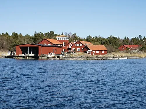
Askö Hans Hillewaert · CC BY-SA 3.0

Climate of Trosa-Vagnhärad socken
Best months for sightseeingBest months for sightseeing: June–August.
This month · November
A cold month
Day 5° · Night 1° · Rain 62 mm
- Hottest month
- July (day 21°)
- Coldest month
- February (night -5°)
- Wettest month
- July (67 mm)
- Driest month
- February (28 mm)
Bars: average monthly low and high temperature. Below: precipitation. Monthly averages for 1970–2000 at about 18 km resolution, adjusted for elevation. Highlighted months are mild and relatively dry. Source: WorldClim 2.1 (CC BY 4.0).
Show values as a table
| Month | Jan | Feb | Mar | Apr | May | Jun | Jul | Aug | Sep | Oct | Nov | Dec |
|---|---|---|---|---|---|---|---|---|---|---|---|---|
| Average high (°C) | 0° | 0° | 3° | 8° | 14° | 19° | 21° | 20° | 15° | 10° | 5° | 2° |
| Average low (°C) | -5° | -5° | -3° | 0° | 5° | 10° | 13° | 12° | 8° | 5° | 1° | -3° |
| Precipitation (mm) | 41 | 28 | 36 | 35 | 32 | 51 | 67 | 55 | 64 | 56 | 62 | 54 |
How to get to Trosa-Vagnhärad socken
The nearest airport is Stockholm Skavsta Airport (NYO), 41 km to the west as the crow flies. The nearest large city is Stockholm, 61 km to the northeast.
Airports
- Stockholm Skavsta Airport (NYO) Nyköping 41 kmwest
- Stockholm-Bromma Airport (BMA) Stockholm 61 kmnorth
- Norrköping Airport (NRK) Norrköping 84 kmwest
Nearby large cities
- Stockholm Population: 1.5M 61 kmnortheast
- Sollentuna Population: 139.6K 69 kmnorth
- Västerås Population: 127.8K 106 kmnorthwest
- Örebro Population: 156K 147 kmwest
- Jönköping Population: 112.8K 234 kmsouthwest
Straight-line distances; road distances are longer. Airport data: OurAirports.
Day trips from Trosa-Vagnhärad socken
Within 100 km: 39 historic and cultural sites, 65 natural sites, 833 lakes, rivers and coasts.
0–25 km80 places
- Ekskär Island 15 kmE
- Norrskär Island 17 kmE
- Lilla Klubben Island 19 kmE
- Brännskär Island 15 kmE
25–60 km245 places
- Gubbholmen Island 36 kmNE
- Oxholmen Island 31 kmE
- Högholmen Island 50 kmNE
- Björkö Island 49 kmNE
60–100 km612 places
- Rindö Island 77 kmNE
- Runmarö Island 83 kmNE
- Granskär Island 73 kmN
- Galtholmen Island 86 kmNE
Straight-line distances.
Places in Trosa-Vagnhärad socken
2 placesMountains & nature1
- Kyrkogårdsskär · Natural site
Lakes, rivers & coasts1
- Gråskär · Island
Nearby attractions & nature
Everything nearbySources & licences
Data last updated: