Österhaninge
Located in Haninge Municipality, Stockholm County Coordinates: 59°07′23″ N 18°10′28″ E
- Population
- 131
- 131
- Elevation
- 47 m
- above sea level
- Local time
- UTC+01:00
- Europe/Stockholm · UTC+01:00
- Airports
- BMA Stockholm-Bromma Airport29 km
- ARN Stockholm-Arlanda Airport60 km
About Österhaninge
Österhaninge is a village. Location: Haninge Municipality, Stockholm County. Population: 131. Elevation: 47 m.
Österhaninge (Swedish pronunciation: [œstɛrˈhânːɪŋɛ]) is an urban area located within Haninge Municipality in Stockholm County, Sweden. It is the birthplace of former Prime Minister of Sweden Fredrik Reinfeldt, black metal frontman and vocalist Dead (Per Yngve Ohlin), and hockey player Kristian Huselius.
Source: Wikipedia · CC BY-SA 4.0
At a glance
- Area
- 32 ha
Source: Wikidata
Photos of Österhaninge
-
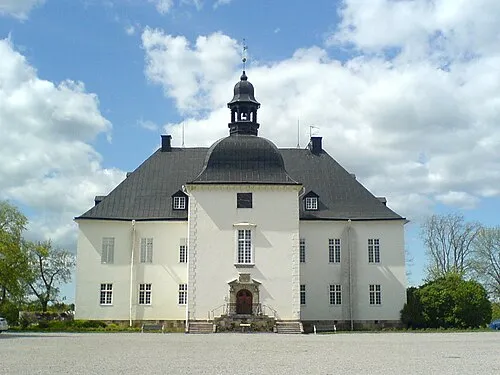
Årsta Castle Ingmar Engström · CC BY-SA 3.0

Population of Österhaninge over time
| 1990 | 110 | |
|---|---|---|
| 1995 | 106 | |
| 2005 | 121 | |
| 2010 | 131 | |
| 2015 | 96 | |
| 2020 | 101 | |
| 2023 | 108 |
Censuses and official estimates; source: Wikidata.
Climate of Österhaninge
Best months for sightseeingBest months for sightseeing: June–August.
This month · November
A cold month
Day 5° · Night 0° · Rain 65 mm
- Hottest month
- July (day 21°)
- Coldest month
- February (night -5°)
- Wettest month
- July (66 mm)
- Driest month
- May (31 mm)
Bars: average monthly low and high temperature. Below: precipitation. Monthly averages for 1970–2000 at about 18 km resolution, adjusted for elevation. Highlighted months are mild and relatively dry. Source: WorldClim 2.1 (CC BY 4.0).
Show values as a table
| Month | Jan | Feb | Mar | Apr | May | Jun | Jul | Aug | Sep | Oct | Nov | Dec |
|---|---|---|---|---|---|---|---|---|---|---|---|---|
| Average high (°C) | 1° | 1° | 3° | 7° | 14° | 18° | 21° | 20° | 15° | 10° | 5° | 2° |
| Average low (°C) | -5° | -5° | -3° | -1° | 4° | 9° | 12° | 11° | 8° | 4° | 0° | -3° |
| Precipitation (mm) | 47 | 32 | 37 | 37 | 31 | 54 | 66 | 61 | 61 | 56 | 65 | 60 |
How to get to Österhaninge
The nearest airport is Stockholm-Bromma Airport (BMA), 29 km to the northwest as the crow flies. For international flights: Stockholm-Arlanda Airport (ARN) (60 km). The nearest large city is Stockholm, 24 km to the north.
Airports
- Stockholm-Bromma Airport (BMA) Stockholm 29 kmnorthwest
- Stockholm-Arlanda Airport (ARN) Stockholm 60 kmnorth
- Stockholm Skavsta Airport (NYO) Nyköping 82 kmsouthwest
Nearby large cities
- Stockholm Population: 1.5M 24 kmnorth
- Sollentuna Population: 139.6K 36 kmnorth
- Västerås Population: 127.8K 107 kmnorthwest
- Örebro Population: 156K 170 kmwest
- Jönköping Population: 112.8K 278 kmsouthwest
Straight-line distances; road distances are longer. Airport data: OurAirports.
Day trips from Österhaninge
Within 100 km: 38 historic and cultural sites, 78 natural sites, 1,081 lakes, rivers and coasts.
0–25 km244 places
- Gubbholmen Island 16 kmS
- Oxholmen Island 25 kmS
- Högholmen Island 12 kmSE
- Björkö Island 12 kmSE
25–60 km614 places
- Rindö Island 33 kmNE
- Runmarö Island 38 kmNE
- Husarö Island 57 kmNE
- Galtholmen Island 41 kmNE
60–100 km339 places
- Lillö Island 81 kmNE
- Granskär Island 64 kmNW
- Högholmen Natural site 85 kmNE
- Hamnholmen Island 86 kmNE
Straight-line distances.
Nearby attractions & nature
Everything nearby-
Årsta Castle Historic site, Haninge Municipality2.1 km SE
-
Mejsgarn Island, Stockholm County3.9 km E
-
Frönäsudd Natural site, Stockholm County4.7 km SE
-
Grönholmen Island, Stockholm County5.1 km SE
-
Långholmen Island, Stockholm County5.4 km SE
-
Ekholmen Island, Stockholm County5.3 km S
Sources & licences
Data last updated: · 2 independent sources