Les Paccottes
Located in Vuisternens-devant-Romont, Glâne District Coordinates: 46°37′24″ N 6°56′26″ E
- Elevation
- 869 m
- above sea level
- Local time
- UTC+01:00
- Europe/Zurich · UTC+01:00
- Airports
- BRN Bern Airport53 km
- GVA Geneva International Airport77 km
About Les Paccottes
Les Paccottes is a village. Location: Vuisternens-devant-Romont, Glâne District. Elevation: 869 m. The best months to visit are July–August. The nearest airport is Bern Airport (53 km). Nearby sights include Haut de Fiaugères and Les Alpettes.
Climate of Les Paccottes
Best months for sightseeingBest months for sightseeing: July–August.
This month · November
A wet month
Day 7° · Night 0° · Rain 113 mm
- Hottest month
- July (day 22°)
- Coldest month
- January (night -4°)
- Wettest month
- June (134 mm)
- Driest month
- March (86 mm)
Bars: average monthly low and high temperature. Below: precipitation. Monthly averages for 1970–2000 at about 18 km resolution, adjusted for elevation. Highlighted months are mild and relatively dry. Source: WorldClim 2.1 (CC BY 4.0).
Show values as a table
| Month | Jan | Feb | Mar | Apr | May | Jun | Jul | Aug | Sep | Oct | Nov | Dec |
|---|---|---|---|---|---|---|---|---|---|---|---|---|
| Average high (°C) | 3° | 4° | 8° | 11° | 16° | 19° | 22° | 22° | 18° | 13° | 7° | 4° |
| Average low (°C) | -4° | -4° | -1° | 2° | 6° | 9° | 11° | 11° | 8° | 4° | 0° | -3° |
| Precipitation (mm) | 98 | 101 | 86 | 94 | 110 | 134 | 118 | 120 | 104 | 107 | 113 | 113 |
How to get to Les Paccottes
The nearest airport is Bern Airport (BRN), 53 km to the northeast as the crow flies. For international flights: Geneva International Airport (GVA) (77 km). The nearest large city is Lausanne, 26 km to the southwest.
Airports
- Bern Airport (BRN) Bern 53 kmnortheast
- Geneva International Airport (GVA) Geneva 77 kmsouthwest
- Annecy Meythet airport (NCY) Annecy 101 kmsouthwest
Nearby large cities
- Lausanne Population: 139.1K 26 kmsouthwest
- Bern Population: 121.6K 53 kmnortheast
- Geneva Population: 201.7K 77 kmsouthwest
- Besançon Population: 128.4K 99 kmnorthwest
- Basel Population: 177.6K 115 kmnortheast
Straight-line distances; road distances are longer. Airport data: OurAirports.
Day trips from Les Paccottes
Within 100 km: 196 historic and cultural sites, 3,840 natural sites, 506 lakes, rivers and coasts.
0–25 km169 places
- Ile de Salagnon Island 21 kmS
- Ile d'Ogoz Island 15 kmNE
- Lac de la Gruyère Lake 13 kmE
- Lac des Joncs Lake 12 kmS
25–60 km1,369 places
- Kleiner Bremgartenwald Mountain 54 kmNE
- Sankt Petersinsel Island 52 kmN
- Lake Wohlen Lake 48 kmNE
- Schwarzsee Lake 27 kmE
60–100 km3,004 places
- Strandbad Neuhaus Beach 67 kmE
- Strandbad Manor Farm Beach 67 kmE
- Strandbad Leissigen Beach 63 kmE
- Strandbad Iseltwald Beach 80 kmE
Straight-line distances.
Nearby attractions & nature
Everything nearby-
Haut de Fiaugères Mountain, Saint-Martin (FR)4.9 km SW
-
Les Alpettes Mountain, Semsales5.4 km SE
-
Mont Olivet Mountain, Le Châtelard6.8 km NE
-
Ancienne chartreuse de la Part-Dieu Historic site, Gruyères6.5 km SE
-
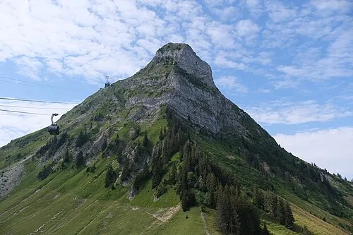 Moléson Mountain, Gruyères10 km SE
-
Etang des Bugnons Lake, Marsens6.4 km NE
Sources & licences
Data last updated: