Saint-Cergue
Located in Nyon District, Canton of Vaud Coordinates: 46°27′05″ N 6°07′38″ E
- Population
- 2,589
- 2.6K
- Elevation
- 1,217 m
- above sea level
- Local time
- UTC+01:00
- Europe/Zurich · UTC+01:00
- Places inside
- 5
- listed under Saint-Cergue
- Airports
- GVA Geneva International Airport24 km
- NCY Annecy Meythet airport58 km
About Saint-Cergue
Saint-Cergue is a municipality. Location: Nyon District, Canton of Vaud. Population: 2,589. Elevation: 1,217 m. The best months to visit are July–August. The nearest airport is Geneva International Airport (24 km). Nearby sights include Pointe de Fin Château and La Dôle.
Photos of Saint-Cergue
-
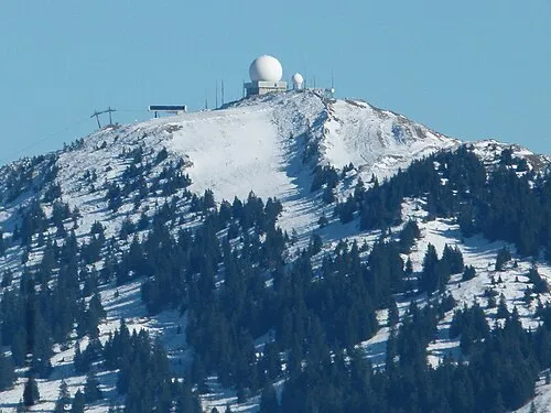
La Dôle Brücke-Osteuropa · CC0

Climate of Saint-Cergue
Best months for sightseeingBest months for sightseeing: July–August.
This month · November
A wet month
Day 5° · Night -1° · Rain 133 mm
- Hottest month
- July (day 19°)
- Coldest month
- January (night -5°)
- Wettest month
- December (134 mm)
- Driest month
- August (99 mm)
Bars: average monthly low and high temperature. Below: precipitation. Monthly averages for 1970–2000 at about 18 km resolution, adjusted for elevation. Highlighted months are mild and relatively dry. Source: WorldClim 2.1 (CC BY 4.0).
Show values as a table
| Month | Jan | Feb | Mar | Apr | May | Jun | Jul | Aug | Sep | Oct | Nov | Dec |
|---|---|---|---|---|---|---|---|---|---|---|---|---|
| Average high (°C) | 1° | 2° | 5° | 8° | 13° | 16° | 19° | 19° | 15° | 10° | 5° | 2° |
| Average low (°C) | -5° | -5° | -3° | 0° | 4° | 7° | 9° | 10° | 7° | 3° | -1° | -4° |
| Precipitation (mm) | 121 | 119 | 101 | 102 | 115 | 123 | 102 | 99 | 117 | 121 | 133 | 134 |
How to get to Saint-Cergue
The nearest airport is Geneva International Airport (GVA), 24 km to the south as the crow flies. The nearest large city is Geneva, 28 km to the south.
Airports
- Geneva International Airport (GVA) Geneva 24 kmsouth
- Annecy Meythet airport (NCY) Annecy 58 kmsouth
- Dole Tavaux Airport (DLE) Dole 84 kmnorthwest
Nearby large cities
- Geneva Population: 201.7K 28 kmsouth
- Lausanne Population: 139.1K 39 kmeast
- Besançon Population: 128.4K 89 kmnorth
- Bern Population: 121.6K 115 kmnortheast
- Villeurbanne Population: 131.4K 123 kmsouthwest
Straight-line distances; road distances are longer. Airport data: OurAirports.
Day trips from Saint-Cergue
Within 100 km: 187 historic and cultural sites, 1,713 natural sites, 351 lakes, rivers and coasts.
0–25 km69 places
- Lac de Joux Lake 24 kmNE
- Lac Aubonne Lake 19 kmE
- Le Mont Risoux Mountain 17 kmN
- Grand Crêt Mountain 25 kmN
25–60 km433 places
- Ile de Salagnon Island 58 kmE
- Lake Leman Lake 26 kmE
- Lac Brenet Lake 29 kmNE
- Etang du Moulin de Vert Lake 31 kmS
60–100 km1,749 places
- Ile d'Ogoz Island 79 kmE
- Schwarzsee Lake 92 kmE
- Lake Neuchâtel Lake 78 kmNE
- Lake Murten Lake 91 kmNE
Straight-line distances.
Places in Saint-Cergue
5 placesBar: population relative to the most populous place in this list.
Cities & villages4
- La Cure · Village
- La Saint Cergue · Neighbourhood
- Les Chesaux · Village
- Les Pralies · Village
Nearby attractions & nature
Everything nearby-
Pointe de Fin Château Mountain, Gingins1.8 km SW
-
La Dôle Mountain, Gingins3.6 km SW
-
La Barillette Mountain, Gingins2.4 km S
-
Émetteur de La Dole Landmark, Gingins2.3 km S
-
Pointe de Poêle Chaud Mountain, Gingins2.4 km SW
-
Le Noirmont Mountain, Arzier-Le Muids3.7 km N
-
Premanon Biathlon Stadium Landmark, Prémanon4.4 km W
-
Mont Pelé Mountain, Arzier-Le Muids5 km N
Sources & licences
Data last updated: