- Population
- 13
- 13
- Elevation
- 462 m
- above sea level
- Local time
- UTC+01:00
- Europe/Zurich · UTC+01:00
- Airports
- ZRH Zürich Airport23 km
- ACH Sankt Gallen Altenrhein Airport66 km
About Oberer Brand
Oberer Brand is a village. Location: Mönchaltorf, Uster District. Population: 13. Elevation: 462 m. The best months to visit are June–September. The nearest airport is Zürich Airport (23 km). Nearby sights include Pfannenstiel and Stollen.
Photos of Oberer Brand
-
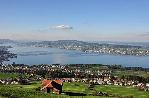
Pfannenstiel Roland zh · CC BY-SA 3.0

Climate of Oberer Brand
Best months for sightseeingBest months for sightseeing: June–September.
This month · November
A cold month
Day 8° · Night 2° · Rain 97 mm
- Hottest month
- July (day 24°)
- Coldest month
- January (night -2°)
- Wettest month
- July (148 mm)
- Driest month
- January (69 mm)
Bars: average monthly low and high temperature. Below: precipitation. Monthly averages for 1970–2000 at about 18 km resolution, adjusted for elevation. Highlighted months are mild and relatively dry. Source: WorldClim 2.1 (CC BY 4.0).
Show values as a table
| Month | Jan | Feb | Mar | Apr | May | Jun | Jul | Aug | Sep | Oct | Nov | Dec |
|---|---|---|---|---|---|---|---|---|---|---|---|---|
| Average high (°C) | 3° | 5° | 10° | 13° | 18° | 21° | 24° | 23° | 19° | 14° | 8° | 4° |
| Average low (°C) | -2° | -2° | 1° | 4° | 8° | 11° | 14° | 14° | 10° | 6° | 2° | -1° |
| Precipitation (mm) | 69 | 82 | 75 | 93 | 112 | 147 | 148 | 141 | 102 | 91 | 97 | 86 |
Other places to visit in this season: June July August September
How to get to Oberer Brand
The nearest airport is Zürich Airport (ZRH), 23 km to the northwest as the crow flies. The nearest large city is Zurich, 16 km to the northwest.
Airports
- Zürich Airport (ZRH) Zurich 23 kmnorthwest
- Sankt Gallen Altenrhein Airport (ACH) St. Gallen 66 kmeast
- Bodensee Airport Friedrichshafen (FDH) Friedrichshafen 72 kmnortheast
Nearby large cities
- Zurich Population: 415.4K 16 kmnorthwest
- Winterthur Population: 111.8K 23 kmnorth
- Basel Population: 177.6K 92 kmwest
- Freiburg im Breisgau Population: 237.5K 102 kmnorthwest
- Bern Population: 121.6K 105 kmwest
Straight-line distances; road distances are longer. Airport data: OurAirports.
Day trips from Oberer Brand
Within 100 km: 537 historic and cultural sites, 5,372 natural sites, 1,038 lakes, rivers and coasts.
0–25 km275 places
- Ufenau Island 10 kmS
- Insel Lützelau Island 10 kmSE
- Schönenwerd Island 11 kmS
- Saffa Insel Island 16 kmW
25–60 km2,024 places
- Mainau Island 57 kmNE
- Fahr Abbey Attraction 25 kmNW
- Dominikanerinsel Konstanz Island 53 kmNE
- Strandbad Steckborn Beach 44 kmNE
60–100 km4,648 places
- Strandbad Neuhaus Beach 98 kmSW
- Strandbad Manor Farm Beach 98 kmSW
- Strandbad Iseltwald Beach 87 kmSW
- Strandbad Brienz Beach 80 kmSW
Straight-line distances.
Nearby attractions & nature
Everything nearby-
Pfannenstiel Mountain, Meilen4.8 km W
-
Stollen Mountain, Männedorf4.1 km SW
-
Seeweidsee Lake, Hombrechtikon4.7 km S
-
Fischottergehege Männedorf Attraction, Männedorf5.4 km SW
-
Lützelsee Lake, Hombrechtikon5.1 km SE
-
Chlisee Lake, Seegräben5.5 km NE
Sources & licences
Data last updated: