
- Elevation
- 1,593 m
- above sea level
- Local time
- UTC+01:00
- Europe/Zurich · UTC+01:00
- Airports
- NCY Annecy Meythet airport77 km
- GVA Geneva International Airport84 km
About La Fouly
La Fouly is a village. Location: Orsières, Entremont District. Elevation: 1,593 m.
La Fouly is a village in Val Ferret in the Swiss canton of Valais. At an altitude of 1,600 metres, it is part of the municipality of Orsières (900 m). It sits at the foot of Mont Dolent (3,823 m) and the Tour Noir (3,836m) in the Mont Blanc massif. La Fouly is a starting point for many hikes into the surrounding mountains and is also a small ski resort. It is also often used as a stopping place for the Tour du Mont Blanc, and is a stage of the Ultra-Trail du Mont-Blanc.
Source: Wikipedia · CC BY-SA 4.0
Photos of La Fouly
-
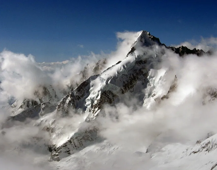
Mont Dolent Wikimedia Commons · CC BY 2.0

Climate of La Fouly
Best months for sightseeingBest months for sightseeing: July–August.
This month · November
A wet month
Day 5° · Night 0° · Rain 164 mm
- Hottest month
- August (day 17°)
- Coldest month
- February (night -4°)
- Wettest month
- November (164 mm)
- Driest month
- July (99 mm)
Bars: average monthly low and high temperature. Below: precipitation. Monthly averages for 1970–2000 at about 18 km resolution, adjusted for elevation. Highlighted months are mild and relatively dry. Source: WorldClim 2.1 (CC BY 4.0).
Show values as a table
| Month | Jan | Feb | Mar | Apr | May | Jun | Jul | Aug | Sep | Oct | Nov | Dec |
|---|---|---|---|---|---|---|---|---|---|---|---|---|
| Average high (°C) | 1° | 1° | 2° | 4° | 9° | 13° | 16° | 17° | 14° | 10° | 5° | 3° |
| Average low (°C) | -4° | -4° | -3° | -2° | 3° | 7° | 10° | 11° | 8° | 5° | 0° | -3° |
| Precipitation (mm) | 149 | 146 | 143 | 139 | 134 | 114 | 99 | 107 | 103 | 138 | 164 | 156 |
How to get to La Fouly
The nearest airport is Annecy Meythet airport (NCY), 77 km to the west as the crow flies. For international flights: Geneva International Airport (GVA) (84 km). The nearest large city is Lausanne, 74 km to the northwest.
Airports
- Annecy Meythet airport (NCY) Annecy 77 kmwest
- Geneva International Airport (GVA) Geneva 84 kmnorthwest
- Turin Airport (TRN) Caselle Torinese (TO) 92 kmsoutheast
Nearby large cities
- Lausanne Population: 139.1K 74 kmnorthwest
- Geneva Population: 201.7K 79 kmwest
- Bern Population: 121.6K 116 kmnorth
- Grenoble Population: 158.6K 137 kmsouthwest
- Besançon Population: 128.4K 168 kmnorthwest
Straight-line distances; road distances are longer. Airport data: OurAirports.
Day trips from La Fouly
Within 100 km: 120 historic and cultural sites, 3,887 natural sites, 464 lakes, rivers and coasts.
0–25 km575 places
- Lac d'Émosson Lake 22 kmNW
- Lac d'Orny Lake 8 kmN
- Lac de la Breye Lake 12 kmN
- Lac de Tsofeiret Lake 22 kmE
25–60 km1,598 places
- Ile de Salagnon Island 59 kmN
- Lac de Fully Lake 27 kmN
- Lac de Derborence Lake 40 kmN
- Arnensee Lake 51 kmN
60–100 km2,298 places
- Strandbad Neuhaus Beach 100 kmNE
- Strandbad Manor Farm Beach 100 kmNE
- Strandbad Leissigen Beach 95 kmNE
- Ile d'Ogoz Island 85 kmN
Straight-line distances.
Nearby attractions & nature
Everything nearby-
La Maye Mountain, Orsières1.9 km W
-
Cretté de la Gouille Mountain, Orsières1.9 km S
-
Pointes des Six Niers Mountain, Orsières2.4 km NW
-
Glacier de l'A Neuve Natural site, Orsières2.7 km W
-
Treutse Bô Mountain, Orsières2.9 km N
-
Mont de la Fouly Mountain, Liddes2.5 km E
Sources & licences
Data last updated: · 2 independent sources