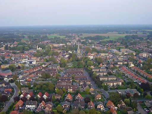
- Population
- 24,137
- 24.1K
- Elevation
- 27 m
- above sea level
- Local time
- UTC+01:00
- Europe/Amsterdam · UTC+01:00
- Airports
- FMO Münster Osnabrück Airport65 km
- NRN Weeze (Niederrhein) Airport74 km
About Haaksbergen
Haaksbergen is a town. Location: Gemeente Haaksbergen, Overijssel. Population: 24,137. Elevation: 27 m. The best months to visit are June–August. The nearest airport is Münster Osnabrück Airport (65 km). Nearby sights include Grote Kerk and Daßberg.
Photos of Haaksbergen
-

Jacek Rużyczka · CC BY-SA 4.0 -

Nationaal Archief · CC0 -

Ypie Attema · CC BY-SA 4.0 -

A. J. van der Wal · CC BY-SA 4.0 -

Nationaal Archief · CC0


Travel notes for Haaksbergen
From Wikivoyage
Haaksbergen is a municipality and city in Overijssel, The Netherlands.
Understand+
The oldest signs of human activity in the municipality that is known to man date back to 800 BC. The city of Haaksbergen, however, dates to 800 AD. The first mention of Haaksbergen dates from an 1188 register of goods, which mentioned grave Hendrik van Dale, who too owned Diepenheim and Ahaus, owned property in Hockesbeghe.
The Buurserbeek stream, was rerouted south of the village to connect to the Schipbeek around 1400. Until then, the Buurserbeek was the main source of water, running through the centre of the village. This rerouting meant that Haaksbergen could connect to the Hanseatic cities of Deventer, Kampen and Zwolle.
In the 19th century textile production became the main source of income for the city. At its peak, 80% of Haaksbergen's population worked in the textile industry. In the early 1970s, on account of cheaper forgein labour, the domestic textile market of the Netherlands collapsed, meaning the end of the industry in Haaksbergen as well as many other cities and towns in the Eastern Netherlands.
Get in+
By public transit:
Buses connect to Haaksbergen on a frequent basis. Line 63 connects to Neede, Enschede and Borculo, line 53 to Eibergen and Hengelo's train station. Line 97 to Holten though Goor. All of these leave from the main 1 Bus station of Haaksbergen, located on the Zeedijk.
Haaksbergen train station hasn't been used for frequent transit for quite some years. Before the Second World War, the station was a stop on the line between Doetinchem and Hengelo. Subsequently, it was used for freight, before being fully closed in 1972. The line is still in use as a heritage railway connecting to Boekelo, several kilometers up north.
By car:
Haaksbergen borders the N18 on the north side of town. This national road connects to Enschede in the northeast, connecting to Doetinchem in the southwest after having become the A18 highway near Varsseveld. The N18 also connects to Eibergen and Groenlo in the south.
Via Enschede the A35 can be reached, which in turn connects to the A1. This route is best used when travelling from Amersfoort and everything north from there. When travelling from the south, travel via Arnhem to which the A12 from The Hague, the A15 from Rotterdam and A50 from Eindhoven connect. From here, follow the signs to Doetinchem, which should guide you to the A12 heading for Zevenaar. Follow the A12 and turn onto the A18 between Zevenaar and Beek to avoid driving into Germany. Follow the A18 and turn right onto the N18 once the highway ends. Following the N18 will send you straight to Haaksbergen.
Source: Wikivoyage · CC BY-SA 4.0 · abridged
Climate of Haaksbergen
Best months for sightseeingBest months for sightseeing: June–August.
This month · November
A cold month
Day 9° · Night 3° · Rain 70 mm
- Hottest month
- July (day 22°)
- Coldest month
- February (night 0°)
- Wettest month
- December (75 mm)
- Driest month
- February (47 mm)
Bars: average monthly low and high temperature. Below: precipitation. Monthly averages for 1970–2000 at about 18 km resolution, adjusted for elevation. Highlighted months are mild and relatively dry. Source: WorldClim 2.1 (CC BY 4.0).
Show values as a table
| Month | Jan | Feb | Mar | Apr | May | Jun | Jul | Aug | Sep | Oct | Nov | Dec |
|---|---|---|---|---|---|---|---|---|---|---|---|---|
| Average high (°C) | 5° | 5° | 9° | 13° | 18° | 20° | 22° | 22° | 18° | 14° | 9° | 6° |
| Average low (°C) | 0° | 0° | 2° | 3° | 8° | 10° | 12° | 12° | 9° | 6° | 3° | 1° |
| Precipitation (mm) | 66 | 47 | 64 | 48 | 59 | 73 | 74 | 60 | 73 | 64 | 70 | 75 |
How to get to Haaksbergen
The nearest airport is Münster Osnabrück Airport (FMO), 65 km to the east as the crow flies. The nearest large city is Enschede, 13 km to the northeast.
Airports
- Münster Osnabrück Airport (FMO) Greven 65 kmeast
- Weeze (Niederrhein) Airport (NRN) Weeze 74 kmsouthwest
- Dortmund Airport (DTM) Dortmund 93 kmsoutheast
Nearby large cities
- Enschede Population: 153.7K 13 kmnortheast
- Apeldoorn Population: 136.7K 53 kmwest
- Zwolle Population: 129.8K 59 kmnorthwest
- Arnhem Population: 162.4K 60 kmwest
- Münster Population: 308.3K 65 kmeast
Straight-line distances; road distances are longer. Airport data: OurAirports.
Day trips from Haaksbergen
Within 100 km: 200 historic and cultural sites, 733 natural sites, 429 lakes, rivers and coasts.
0–25 km18 places
- Poiksbrock Natural site 20 kmSE
- Liesner Wald Natural site 24 kmSE
- Fürsten Busch Natural site 18 kmS
- Naturschutzgebiet Eiler Mark Natural site 23 kmE
25–60 km393 places
- Putjensberg Mountain 57 kmNW
- Strang Lake 52 kmSW
- Halterner Talsperre Lake 56 kmSE
- Schmales Meer Lake 48 kmSW
60–100 km951 places
- Kasteel Arcen Historic site 85 kmSW
- Else River 99 kmSE
- Werse River 66 kmE
- Ahse River 93 kmSE
Straight-line distances.
Nearby attractions & nature
Everything nearby-
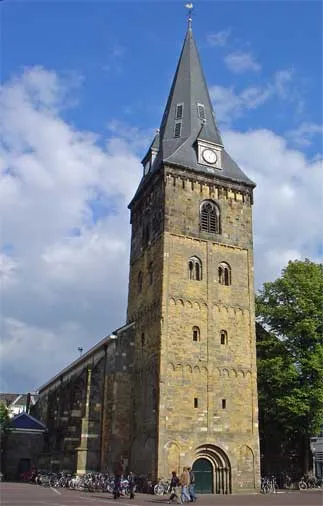 Grote Kerk Attraction, Enschede Municipality13 km NE
-
Daßberg Mountain, Vreden16 km S
-
Ölbach River, North Rhine-Westphalia11 km S
-
Zuurberg Mountain, Gemeente Rijssen-Holten24 km NW
-
Lokerenk Mountain, Gemeente Rijssen-Holten25 km NW
-
Apenberg Mountain, Gemeente Hof van Twente19 km NW
-
Paasberg Mountain, Losser Municipality25 km NE
-
Naturschutzgebiet Flörbach Natural site, Gronau (Westf.)17 km E
Sources & licences
Data last updated: