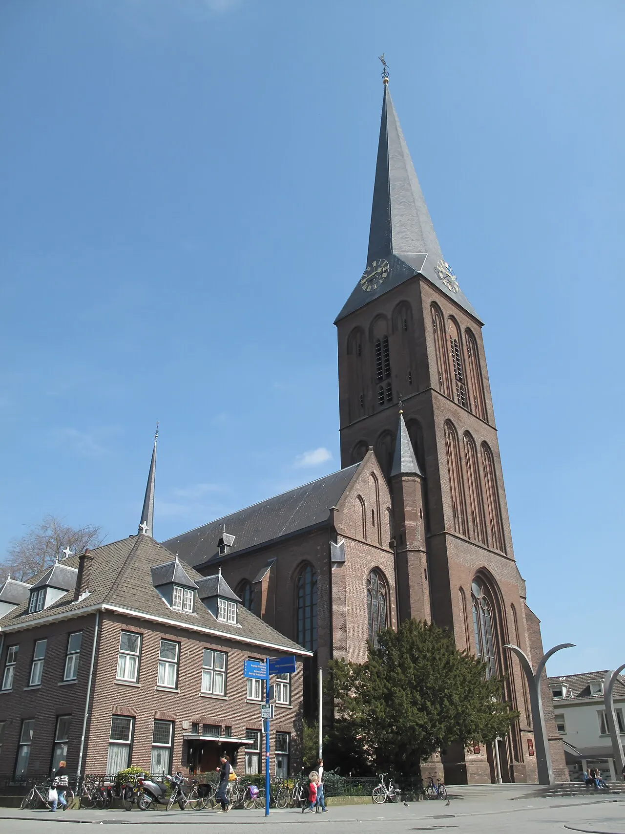
- Population
- 82,311
- 82.3K
- Elevation
- 18 m
- above sea level
- Local time
- UTC+01:00
- Europe/Amsterdam · UTC+01:00
- Airports
- FMO Münster Osnabrück Airport63 km
- NRN Weeze (Niederrhein) Airport86 km
About Hengelo
Hengelo is a city. Location: Hengelo Municipality, Overijssel. Population: 82,311. Elevation: 18 m. The best months to visit are June–August. The nearest airport is Münster Osnabrück Airport (63 km). Nearby sights include Grote Kerk and Paasberg.
Photos of Hengelo
-

Tijmen Stam User:IIVQ · CC BY-SA 3.0 -

Gewild · CC BY-SA 4.0 -

Petraotten · CC BY-SA 3.0 -

Anefo · CC0 -

User:Titico · Public domain


Travel notes for Hengelo
From Wikivoyage
Hengelo is a city in the Eastern Netherlands, close to the border with Germany. It's not on the usual tourist map, but is easy to reach and if you do find yourself here, it has some interesting museums and serves as a regional centre for shopping.
Understand+
Hengelo started out as just another hamlet, and only gained growth during the Industrial Revolution, which made the town a city by bringing textile industries to the region. Over time, this industry moved to nearby Enschede, which made space for more heavy industry, starting with C.T. Stork opening a heavy machinery part factory into the city in 1868. Stork was soon followed by Hazemeyer, Heemaf, the Royal Dutch Saltindustry and Hollandse Signaalapparaten. The growth in industry brought a boom to the city's inhabitants. On the other hand, the heavy industry made Hengelo a strategic target during the Second World War. The historic centre of the city was destroyed nearly entirely in October of 1944. Post-war, Hengelo became a wederopbouwgemeente, meaning that all that remained amongst the ruins, stood a high likelihood of not surviving the years following the war, as the city and municipality now focused on rebuilding and rehousing instead of restoring what once was. The buildings that were lucky enough to stand the test of time such as the 1890 Roman-Catholic Saint Lambertusbasilica do bring some history to a city that had the rest of its history wiped away.
Get in+
By car:
From Amsterdam:
Getting from Amsterdam to Hengelo could not be any more straightforward. To do so, simply head for the A1, which you use to drive towards Amersfoort. Simply follow the A1 past Barneveld, Apeldoorn and Deventer until the A1 merges with the A35 near Borne, and then separates ways again shortly after. At this point, use the A1's exits 30 and 31 to get to northern Hengelo and the A35's exits 27 and 28 to get to west Hengelo.
From Arnhem:
Getting to Hengelo from Arnhem and the Southern Netherlands is less straightforward. Arnhem will be the city that you come by either way, whether that be using the A12, A15, A50 or any other route. There are two main ways for getting to Hengelo, namely the A50, which connects to the A1 near Apeldoorn, where you should follow directions to Deventer. As soon as you join the A1, you follow the same directions you would when coming from Amsterdam: Stick to the A1, and use the A1 or A35 to get to north or west Hengelo after passing Borne.
Alternatively, the A12, followed by A18 and N18, dubbed the Twenteroute is another option. The route takes you through the Liemers, by Doetinchem and through the Achterhoek. The route is more direct, though it doesn't have to be quicker. The N18 up to Groenlo is hated for having only a single lane in either direction, shared by lorries and cars. The Twenteroute is a lorry-heavy route, so traffic will not be moving as fast as on a highway. After the N18 terminates at Enschede, turn left onto the Usselerrondweg, turn left after passing under the Westerval, a small branch of the A35 heading into the city, after which you turn right onto the A35, heading for Hengelo. Again, exits 27 and 28 service the city. Once 2018 rolls around, the new northern half of the N18 (everything past Groenlo), will have been completed. At this point the N18 connects directly onto the A35, and will only require a turn left onto the highway heading for Hengelo.
By train:
Source: Wikivoyage · CC BY-SA 4.0 · abridged
Climate of Hengelo
Best months for sightseeingBest months for sightseeing: June–August.
This month · November
A cold month
Day 9° · Night 3° · Rain 72 mm
- Hottest month
- August (day 23°)
- Coldest month
- February (night -1°)
- Wettest month
- December (76 mm)
- Driest month
- February (46 mm)
Bars: average monthly low and high temperature. Below: precipitation. Monthly averages for 1970–2000 at about 18 km resolution, adjusted for elevation. Highlighted months are mild and relatively dry. Source: WorldClim 2.1 (CC BY 4.0).
Show values as a table
| Month | Jan | Feb | Mar | Apr | May | Jun | Jul | Aug | Sep | Oct | Nov | Dec |
|---|---|---|---|---|---|---|---|---|---|---|---|---|
| Average high (°C) | 5° | 5° | 9° | 13° | 18° | 20° | 22° | 23° | 19° | 14° | 9° | 6° |
| Average low (°C) | 0° | -1° | 2° | 3° | 8° | 10° | 12° | 12° | 9° | 6° | 3° | 1° |
| Precipitation (mm) | 67 | 46 | 64 | 48 | 58 | 74 | 74 | 62 | 72 | 64 | 72 | 76 |
How to get to Hengelo
The nearest airport is Münster Osnabrück Airport (FMO), 63 km to the east as the crow flies. The nearest large city is Enschede, 9 km to the southeast.
Airports
- Münster Osnabrück Airport (FMO) Greven 63 kmeast
- Weeze (Niederrhein) Airport (NRN) Weeze 86 kmsouthwest
- Groningen Airport Eelde (GRQ) Groningen 96 kmnorth
Nearby large cities
- Enschede Population: 153.7K 9 kmsoutheast
- Zwolle Population: 129.8K 55 kmnorthwest
- Apeldoorn Population: 136.7K 57 kmwest
- Münster Population: 308.3K 66 kmsoutheast
- Arnhem Population: 162.4K 68 kmsouthwest
Straight-line distances; road distances are longer. Airport data: OurAirports.
Day trips from Hengelo
Within 100 km: 183 historic and cultural sites, 773 natural sites, 435 lakes, rivers and coasts.
0–25 km31 places
- Dreiländersee Lake 20 kmE
- Bovenfeld Natural site 24 kmN
- Mickenquelle Natural site 25 kmN
- Naturschutzgebiet Eiler Mark Natural site 19 kmE
25–60 km326 places
- Putjensberg Mountain 56 kmW
- Millinger Meer Lake 59 kmSW
- Mickelmeer Lake 51 kmNE
- Kleines Heiliges Meer Lake 59 kmE
60–100 km1,034 places
- Kasteel Arcen Historic site 98 kmSW
- Werse River 66 kmSE
- Ahse River 97 kmSE
- Wijlermeer Lake 76 kmSW
Straight-line distances.
Hengelo and similar cities
Side by side with cities of similar size in the same country: population, elevation and climate.
| Measure | Hengelo | Lelystad | Assen | Venlo |
|---|---|---|---|---|
| Population | 82.3K | 79.8K | 68.8K | 102K |
| Elevation | 18 m | -1 m | 12 m | 24 m |
| Summer day (hottest month) | 23° | 22° | 22° | 23° |
| Winter night (coldest month) | -1° | 1° | -1° | 0° |
| Annual rainfall | 777 mm | 803 mm | 829 mm | 734 mm |
| Best months | Jun–Aug | Jun–Aug | Jun–Aug | Jun–Aug |
| Distance | — | 94 km | 83 km | 109 km |
Climate values are 1970–2000 monthly averages; straight-line distance.
Nearby attractions & nature
Everything nearby-
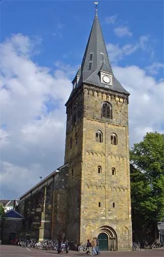 Grote Kerk Attraction, Enschede Municipality8.6 km SE
-
Paasberg Mountain, Losser Municipality14 km NE
-
Kersberg Mountain, Gemeente Dinkelland18 km N
-
Tutenberg Mountain, Tubbergen Municipality19 km N
-
Braamberg Mountain, Tubbergen Municipality19 km N
-
Apenberg Mountain, Gemeente Hof van Twente18 km W
-
Zuurberg Mountain, Gemeente Rijssen-Holten24 km W
-
Galgenberg Mountain, Lower Saxony21 km N
Sources & licences
Data last updated: