Sarhan
Located in Merkezefendi İlçesi, Denizli Province Coordinates: 37°47′44″ N 28°58′52″ E
- Elevation
- 629 m
- above sea level
- Local time
- UTC+03:00
- Europe/Istanbul · UTC+03:00
- Airports
- DNZ Çardak Airport63 km
- DLM Dalaman International Airport121 km
About Sarhan
Sarhan is a village. Location: Merkezefendi İlçesi, Denizli Province. Elevation: 629 m. The best months to visit are May, October. The nearest airport is Çardak Airport (63 km). Nearby sights include Gök Tepesi and Dikmen Tepesi.
Climate of Sarhan
Best months for sightseeingBest months for sightseeing: May, October.
This month · November
Outside the best season
Day 16° · Night 7° · Rain 72 mm
Better nearby cities in November
- Aydin · 100 km west19°
- Alanya · 302 km southeast21°
- Hottest month
- July (day 33°)
- Coldest month
- January (night 2°)
- Wettest month
- December (121 mm)
- Driest month
- August (12 mm)
Bars: average monthly low and high temperature. Below: precipitation. Monthly averages for 1970–2000 at about 18 km resolution, adjusted for elevation. Highlighted months are mild and relatively dry. Source: WorldClim 2.1 (CC BY 4.0).
Show values as a table
| Month | Jan | Feb | Mar | Apr | May | Jun | Jul | Aug | Sep | Oct | Nov | Dec |
|---|---|---|---|---|---|---|---|---|---|---|---|---|
| Average high (°C) | 10° | 11° | 14° | 19° | 24° | 29° | 33° | 33° | 29° | 22° | 16° | 11° |
| Average low (°C) | 2° | 3° | 5° | 8° | 12° | 16° | 19° | 19° | 15° | 11° | 7° | 4° |
| Precipitation (mm) | 112 | 94 | 76 | 57 | 49 | 28 | 16 | 12 | 18 | 44 | 72 | 121 |
How to get to Sarhan
The nearest airport is Çardak Airport (DNZ), 63 km to the east as the crow flies. For international flights: Dalaman International Airport (DLM) (121 km). The nearest large city is Merkezefendi, 6 km to the east.
Airports
- Çardak Airport (DNZ) Denizli 63 kmeast
- Dalaman International Airport (DLM) Dalaman 121 kmsouth
- Süleyman Demirel International Airport (ISE) Isparta 122 kmeast
Nearby large cities
- Merkezefendi Population: 280.3K 6 kmeast
- Denizli Population: 313.2K 10 kmeast
- Nazilli Population: 119.4K 60 kmwest
- Aydin Population: 163K 101 kmwest
- Uşak Population: 369.4K 104 kmnorth
Straight-line distances; road distances are longer. Airport data: OurAirports.
Day trips from Sarhan
Within 100 km: 18 historic and cultural sites, 273 natural sites, 196 lakes, rivers and coasts.
0–25 km47 places
- Gök Tepesi Mountain 4 kmSW
- Çubuk Dağı Mountain 25 kmNW
- Aktaş Tepesi Mountain 11 kmW
- Ak Dağ Mountain 15 kmW
25–60 km132 places
- Kemer Barajı Lake 47 kmSW
- Uyluk Dağı Mountain 48 kmS
- Yılanlı Tepe Mountain 31 kmSE
- Yelkenli Dağı Mountain 55 kmS
60–100 km308 places
- Lake Yarışlı Lake 91 kmE
- Lake Salda Lake 67 kmSE
- Lake Karataş Lake 99 kmSE
- Karaman Gölü Lake 89 kmS
Straight-line distances.
Nearby attractions & nature
Everything nearby-
Gök Tepesi Mountain, Merkezefendi İlçesi4.3 km SW
-
Dikmen Tepesi Mountain, Babadağ İlçesi8.6 km W
-
Tokluyatak Tepesi Mountain, Merkezefendi İlçesi9.2 km S
-
Boludüzü Tepesi Mountain, Babadağ İlçesi7.9 km NW
-
Şalap Tepesi Mountain, Merkezefendi İlçesi15 km SE
-
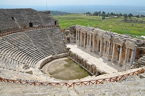 Hierapolis Historic site, Pamukkale İlçesi19 km NE
Sources & licences
Data last updated: