- Elevation
- 5 m
- above sea level
- Local time
- UTC+03:00
- Europe/Istanbul · UTC+03:00
- Airports
- SAW Istanbul Sabiha Gökçen International Airport24 km
- YEI Bursa Yenişehir Airport51 km
About Kapanca
Kapanca is a village. Location: Çiftlikköy İlçesi, Yalova Province. Elevation: 5 m. The best months to visit are May, September–October. The nearest airport is Istanbul Sabiha Gökçen International Airport (24 km). Nearby sights include Ağıl Deresi and Elmalı Dere.
Climate of Kapanca
Best months for sightseeingBest months for sightseeing: May, September–October.
This month · November
Outside the best season
Day 16° · Night 8° · Rain 83 mm
Better nearby cities in November
- Aydin · 341 km southwest19°
- Hottest month
- July (day 29°)
- Coldest month
- January (night 3°)
- Wettest month
- December (111 mm)
- Driest month
- July (27 mm)
Bars: average monthly low and high temperature. Below: precipitation. Monthly averages for 1970–2000 at about 18 km resolution, adjusted for elevation. Highlighted months are mild and relatively dry. Source: WorldClim 2.1 (CC BY 4.0).
Show values as a table
| Month | Jan | Feb | Mar | Apr | May | Jun | Jul | Aug | Sep | Oct | Nov | Dec |
|---|---|---|---|---|---|---|---|---|---|---|---|---|
| Average high (°C) | 10° | 10° | 12° | 18° | 22° | 27° | 29° | 29° | 26° | 21° | 16° | 12° |
| Average low (°C) | 3° | 3° | 4° | 8° | 12° | 16° | 19° | 19° | 16° | 12° | 8° | 5° |
| Precipitation (mm) | 93 | 70 | 63 | 49 | 39 | 34 | 27 | 34 | 51 | 78 | 83 | 111 |
How to get to Kapanca
The nearest airport is Istanbul Sabiha Gökçen International Airport (SAW), 24 km to the north as the crow flies. The nearest large city is Gebze, 15 km to the northeast.
Airports
- Istanbul Sabiha Gökçen International Airport (SAW) Pendik, Istanbul 24 kmnorth
- Bursa Yenişehir Airport (YEI) Yenişehir 51 kmsouth
- İstanbul Airport (IST) Istanbul 84 kmnorthwest
Nearby large cities
- Gebze Population: 281.4K 15 kmnortheast
- Sultanbeyli Population: 358.2K 32 kmnorth
- Maltepe Population: 427K 32 kmnorthwest
- Sancaktepe Population: 489.8K 37 kmnorth
- Ataşehir Population: 361.6K 39 kmnorthwest
Straight-line distances; road distances are longer. Airport data: OurAirports.
Day trips from Kapanca
Within 100 km: 156 historic and cultural sites, 161 natural sites, 277 lakes, rivers and coasts.
0–25 km42 places
- Hayırsızada Island 14 kmNW
- Hersek Gölü Lake 15 kmE
- Kocabayır Tepesi Mountain 22 kmNE
- Karlık Dağ Mountain 17 kmSE
25–60 km315 places
- Andirovitha Island Island 25 kmNW
- Pita Island Island 32 kmNW
- Princes Islands Island 34 kmNW
- Proti Island Island 36 kmNW
60–100 km237 places
- Yeniköy Plaj Beach 88 kmW
- Karaburun Plajı Beach 91 kmNW
- Karaburun Sahili Plaj Beach 93 kmNW
- Yeniköy Plajı Beach 89 kmNW
Straight-line distances.
Nearby attractions & nature
Everything nearby-
Ağıl Deresi River, Yalova Province2.3 km SW
-
Elmalı Dere River, Yalova Province4 km SW
-
Kılıç Deresi River, Yalova Province4.6 km E
-
Balaban Deresi River, Yalova Province5.5 km SW
-
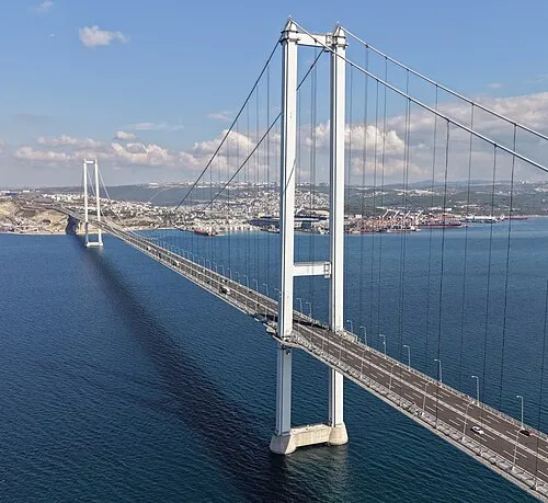 Osman Gazi Bridge Landmark, Altınova İlçesi16 km NE
-
Yalova Atatürk Stadyomu Landmark, Yalova7.6 km SW
Sources & licences
Data last updated: