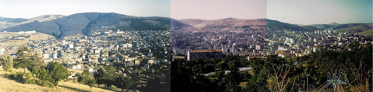
- Elevation
- 1,556 m
- above sea level
- Local time
- UTC+03:00
- Europe/Istanbul · UTC+03:00
- Places inside
- 203
- listed under Yozgat
- Airports
- NAV Nevşehir Kapadokya Airport117 km
- ASR Kayseri Erkilet International Airport129 km
About Yozgat
Yozgat is a district. Location: Yozgat Province, Turkey. The best months to visit are June–September. The nearest airport is Nevşehir Kapadokya Airport (117 km). Nearby sights include Topçu Göleti and Akkale Tepesi.
Climate of Yozgat
Best months for sightseeingBest months for sightseeing: June–September.
This month · November
A cold month
Day 9° · Night -2° · Rain 49 mm
Better nearby cities in November
- Adana · 317 km south21°
- Tarsus · 321 km south22°
- Osmaniye · 328 km southeast21°
- Hottest month
- August (day 26°)
- Coldest month
- January (night -7°)
- Wettest month
- December (65 mm)
- Driest month
- August (8 mm)
Bars: average monthly low and high temperature. Below: precipitation. Monthly averages for 1970–2000 at about 18 km resolution, adjusted for elevation. Highlighted months are mild and relatively dry. Source: WorldClim 2.1 (CC BY 4.0).
Show values as a table
| Month | Jan | Feb | Mar | Apr | May | Jun | Jul | Aug | Sep | Oct | Nov | Dec |
|---|---|---|---|---|---|---|---|---|---|---|---|---|
| Average high (°C) | 1° | 3° | 8° | 13° | 18° | 22° | 26° | 26° | 22° | 16° | 9° | 3° |
| Average low (°C) | -7° | -6° | -3° | 1° | 5° | 8° | 11° | 11° | 7° | 3° | -2° | -5° |
| Precipitation (mm) | 56 | 50 | 49 | 56 | 56 | 41 | 13 | 8 | 17 | 31 | 49 | 65 |
Other places to visit in this season: June July August September
How to get to Yozgat
The nearest airport is Nevşehir Kapadokya Airport (NAV), 117 km to the south as the crow flies. The nearest large city is Çorum, 84 km to the north.
Airports
- Nevşehir Kapadokya Airport (NAV) Nevşehir 117 kmsouth
- Kayseri Erkilet International Airport (ASR) Kayseri 129 kmsoutheast
- Amasya Merzifon Airport (MZH) Amasya 129 kmnortheast
Nearby large cities
- Çorum Population: 269.6K 84 kmnorth
- Kırşehir Population: 150.7K 91 kmsouthwest
- Kirikkale Population: 187K 111 kmwest
- Turhal Population: 110.9K 127 kmnortheast
- Amasya Population: 114.9K 129 kmnortheast
Straight-line distances; road distances are longer. Airport data: OurAirports.
Day trips from Yozgat
Within 100 km: 76 historic and cultural sites, 631 natural sites, 178 lakes, rivers and coasts.
0–25 km64 places
- Topçu Göleti Lake 8 kmS
- Gözbaba Tepesi Mountain 21 kmE
- Dokuz Tepe Mountain 17 kmS
- Çatal Tepe Mountain 20 kmW
25–60 km298 places
- Alışar Höyük Historic site 45 kmSE
- Örükaya Göleti Lake 34 kmN
- Mükremin Göleti Lake 36 kmE
- Nigaroğlu Göleti Lake 53 kmW
60–100 km523 places
- Maşat Höyük Historic site 90 kmNE
- Lake Suğla Lake 74 kmSW
- Çoğun Barajı Lake 79 kmSW
- Elekçi Gölü Lake 73 kmNW
Straight-line distances.
Places in Yozgat
203 placesCities & villages33
- Cıraderesi · Village
- Çorak · Village
- Dağyenicesi · Village
- Dambasan · Village
- Darıca · Village
- Dayılı · Village
- Delihasanlı · Village
- Derbent · Village
- Dereboymul · Village
- Derekışla · Village
- Deremahal · Village
- Deremumlu · Village
- Dönederesi · Village
- Erkekli · Village
- Esenli · Village
- Evci · Village
- Fakıbeyli · Village
- Gelingüllü · Village
- Gevrek · Village
- Gökçekışla · Village
- Güdülelmahacılı · Village
- Güllük · Village
- Güllüoluk · Village
- Gülyayla · Village
- Hamzalı · Village
- Haydarbeyli · Village
- İnceçayır · Village
- İşleğen · Village
- Kababel · Village
- Kaleköy · Village
- Kalınbük · Village
- Karabıyık · Village
- Karacalar · Village
Mountains & nature26
- Çıngırdaklı Tepe · Mountain
- Çorak Tepe · Mountain
- Çorak Tepesi · Mountain
- Darboğaz Tepesi · Mountain
- Dede Tepesi · Mountain
- Delibayır Tepesi · Mountain
- Dokuz Tepe · Mountain
- Domalan Tepesi · Mountain
- Düzkıran Tepesi · Mountain
- Elmalı Tepe · Mountain
- Elmalı Tepe · Mountain
- Elmas Pınarı · Natural site
- Erikliarkaç Tepesi · Mountain
- Erikliyokuş Tepesi · Mountain
- Fırıngediği Tepesi · Mountain
- Geyik Tepesi · Mountain
- Gölpınar Tepesi · Mountain
- Hıdırlık Tepesi · Mountain
- İnağzı Tepesi · Mountain
- İncekarış Tepesi · Mountain
- Isıtma Tepe · Mountain
- İvez Deresi · Mountain
- Kabak Tepesi · Mountain
- Kale Tepesi · Mountain
- Karaarma Tepesi · Mountain
- Karakaya Tepesi · Mountain
Lakes, rivers & coasts1
- Çorak Dere · River
Nearby attractions & nature
Everything nearby-
Topçu Göleti Lake, Yozgat Province7.9 km S
-
Akkale Tepesi Mountain, Yerköy İlçesi13 km SW
-
Delimehmedin Pınarı Natural site, Yozgat Province13 km E
-
Demirci Deresi River, Yozgat Province14 km SW
-
Tekemehmet Pınarı Natural site, Yozgat Province18 km W
-
Boğaz Deresi River, Yozgat Province15 km E
Sources & licences
Data last updated: