St. Mawes Castle
Located in St. Just-in-Roseland, Cornwall Coordinates: 50°09′20″ N 5°01′26″ W
- Local time
- UTC+00:00
- Europe/London · UTC+00:00
- Elevation
- 14 m
- above sea level
- Airports
- NQY Cornwall Airport Newquay32 km
- EXT Exeter International Airport131 km
About St. Mawes Castle
St. Mawes Castle is a historic site. Location: St. Just-in-Roseland, Cornwall.
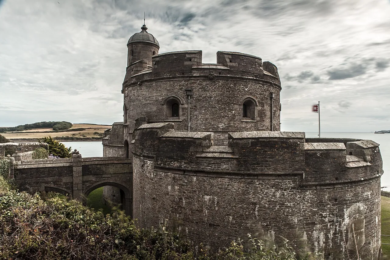
St Mawes Castle (Cornish: Kastel Lannvowsedh) is an artillery fort constructed by Henry VIII near Falmouth, Cornwall, between 1540 and 1542. It formed part of the King's Device programme to protect against invasion from France and the Holy Roman Empire, and defended the Carrick Roads waterway at the mouth of the River Fal. The castle was built under the direction of Thomas Treffry to a clover leaf design, with a four-storey central tower and three protruding, round bastions that formed gun platforms.
Source: Wikipedia · CC BY-SA 4.0
At a glance
- Built
- 1539
- Heritage designation
- Grade I listed building, scheduled monument
- Official website
- english-heritage.org.uk
Source: Wikidata
Photos of St. Mawes Castle
-

Tom P from Scottish Borders, Scotland · CC BY-SA 2.0 -

Lewis Clarke · CC BY-SA 2.0 -

Tom P from Scottish Borders, Scotland · CC BY-SA 2.0


Climate of St. Mawes Castle
Best months for sightseeingBest months for sightseeing: June–September.
This month · November
A wet month
Day 12° · Night 7° · Rain 120 mm
- Hottest month
- August (day 19°)
- Coldest month
- February (night 5°)
- Wettest month
- January (130 mm)
- Driest month
- July (53 mm)
Bars: average monthly low and high temperature. Below: precipitation. Monthly averages for 1970–2000 at about 18 km resolution, adjusted for elevation. Highlighted months are mild and relatively dry. Source: WorldClim 2.1 (CC BY 4.0).
Show values as a table
| Month | Jan | Feb | Mar | Apr | May | Jun | Jul | Aug | Sep | Oct | Nov | Dec |
|---|---|---|---|---|---|---|---|---|---|---|---|---|
| Average high (°C) | 10° | 10° | 11° | 12° | 15° | 17° | 19° | 19° | 17° | 15° | 12° | 10° |
| Average low (°C) | 5° | 5° | 5° | 6° | 8° | 11° | 13° | 13° | 12° | 10° | 7° | 6° |
| Precipitation (mm) | 130 | 100 | 89 | 62 | 60 | 62 | 53 | 71 | 86 | 108 | 120 | 130 |
Other places to visit in this season: June July August September
How to get to St. Mawes Castle
The nearest airport is Cornwall Airport Newquay (NQY), 32 km to the north as the crow flies. For international flights: Cardiff International Airport (CWL) (182 km). The nearest large city is Plymouth, 67 km to the east.
Airports
- Cornwall Airport Newquay (NQY) Newquay 32 kmnorth
- Exeter International Airport (EXT) Exeter, Devon 131 kmnortheast
- Cardiff International Airport (CWL) Cardiff 182 kmnortheast
Nearby large cities
- Plymouth Population: 260.2K 67 kmeast
- Exeter Population: 130.7K 124 kmnortheast
- Swansea Population: 300.4K 180 kmnortheast
- Cardiff Population: 372.1K 196 kmnortheast
- Brest Population: 144.9K 200 kmsouth
Straight-line distances; road distances are longer. Airport data: OurAirports.
Day trips from St. Mawes Castle
Within 100 km: 116 historic and cultural sites, 468 natural sites, 150 lakes, rivers and coasts.
0–25 km91 places
- Vault Beach Beach 19 kmNE
- Gylly Beach Beach 3 kmW
- Swanpool Beach Beach 4 kmSW
- Chapel Porth Beach Beach 22 kmNW
25–60 km272 places
- Sennen Cove Beach 49 kmW
- Tregantle Beach Beach 58 kmNE
- Lansallos Beach Beach 37 kmNE
- Pedn Vounder Beach Beach 46 kmW
60–100 km371 places
- Burgh Island Island 81 kmE
- Lannacombe Beach Beach 96 kmE
- Gara Rock beach Beach 91 kmE
- South Milton Sands Beach 84 kmE
Straight-line distances.
Nearby attractions & nature
Everything nearby-
Lamorran House Gardens Attraction, St. Just-in-Roseland0.3 km NE
-
St. Anthony Lighthouse Landmark, Gerrans1.7 km S
-
Drake's Downs Mountain, Gerrans1.8 km SE
-
Pendennis Castle Mountain, Falmouth1.9 km SW
-
Bohortha Hill Mountain, Gerrans2 km E
-
Windmill Hill Mountain, St. Just-in-Roseland2.7 km N
-
Trewince Hill Mountain, Gerrans2.5 km NE
-
Porthmellin Head Natural site, England3 km E
Nearest towns and villages
-
Falmouth Town, Falmouth3.4 km W
-
Saint Mawes Village, St. Just-in-Roseland0.9 km NE
-
Flushing Village, Mylor3.4 km W
-
Portscatho Village, Gerrans4.1 km NE
Sources & licences
Data last updated: · 2 independent sources