
- Elevation
- 63 m
- above sea level
- Local time
- UTC+00:00
- Europe/London · UTC+00:00
- Airports
- IOM Isle of Man Airport85 km
- LPL Liverpool John Lennon Airport130 km
About Calder Bridge
Calder Bridge is a village. Location: Ponsonby, Cumberland. Elevation: 63 m.
Calder Bridge (also Calderbridge) is a small village in Cumbria in England. It is located between the hamlets of Gosforth and Beckermet and lies on the River Calder. It is around 1 mile northeast from the Sellafield nuclear plant—Calder Hall Nuclear Power Station was the world's first major nuclear power station when it opened in 1956. The village contains the Grade II listed St Bridget's Church, the Grade II listed Pelham House (formerly Ponsonby Hall) and the Stanley Arms inn.
Source: Wikipedia · CC BY-SA 4.0
Photos of Calder Bridge
-
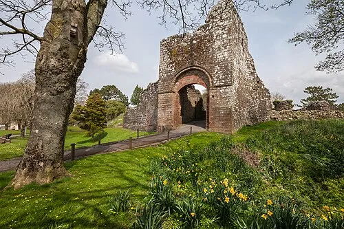
Egremont Castle Paul Lakin · CC BY 3.0

Climate of Calder Bridge
Best months for sightseeingBest months for sightseeing: June–August.
This month · November
A wet month
Day 9° · Night 3° · Rain 137 mm
- Hottest month
- July (day 19°)
- Coldest month
- January (night 1°)
- Wettest month
- October (140 mm)
- Driest month
- May (72 mm)
Bars: average monthly low and high temperature. Below: precipitation. Monthly averages for 1970–2000 at about 18 km resolution, adjusted for elevation. Highlighted months are mild and relatively dry. Source: WorldClim 2.1 (CC BY 4.0).
Show values as a table
| Month | Jan | Feb | Mar | Apr | May | Jun | Jul | Aug | Sep | Oct | Nov | Dec |
|---|---|---|---|---|---|---|---|---|---|---|---|---|
| Average high (°C) | 6° | 7° | 9° | 11° | 15° | 17° | 19° | 18° | 16° | 13° | 9° | 7° |
| Average low (°C) | 1° | 1° | 2° | 4° | 6° | 9° | 11° | 11° | 9° | 6° | 3° | 2° |
| Precipitation (mm) | 137 | 98 | 103 | 76 | 72 | 74 | 80 | 96 | 108 | 140 | 137 | 140 |
How to get to Calder Bridge
The nearest airport is Isle of Man Airport (IOM), 85 km to the southwest as the crow flies. The nearest large city is Blackpool, 75 km to the south.
Airports
- Isle of Man Airport (IOM) Castletown, Rushen 85 kmsouthwest
- Liverpool John Lennon Airport (LPL) Liverpool 130 kmsouth
- Newcastle International Airport (NCL) Newcastle upon Tyne, Tyne and Wear 133 kmnortheast
Nearby large cities
- Blackpool Population: 145K 75 kmsouth
- Preston Population: 313.3K 91 kmsoutheast
- Blackburn Population: 146.5K 101 kmsoutheast
- Burnley Population: 149.4K 108 kmsoutheast
- Wigan Population: 175.4K 114 kmsoutheast
Straight-line distances; road distances are longer. Airport data: OurAirports.
Day trips from Calder Bridge
Within 100 km: 506 historic and cultural sites, 2,071 natural sites, 430 lakes, rivers and coasts.
0–25 km442 places
- St. Bees Beach Seafront Beach 10 kmNW
- Smithymire Island Island 24 kmE
- Scale Island Island 16 kmNE
- Little Island Island 24 kmSE
25–60 km1,022 places
- British Isles Island 60 kmSW
- High Moor Mountain 33 kmSE
- Roanhead Beach Beach 34 kmSE
- Powillimount Beach Beach 51 kmN
60–100 km1,543 places
- Ainsdale Beach Beach 97 kmS
- St Anne's Beach Beach 82 kmS
- Murrays Isles Island 64 kmNW
- Islands of Fleet Island 62 kmNW
Straight-line distances.
Nearby attractions & nature
Everything nearby-
Calder Abbey Historic site, St. Bridget Beckermet0.9 km NE
-
Sella Park Landmark, St. Bridget Beckermet1 km SW
-
In Fell Mountain, Ponsonby1.8 km E
-
Abbey Flatts Historic site, St. Bridget Beckermet1.8 km NE
-
Infell Wood Landmark, Ponsonby1.8 km E
-
Caernarvon Castle Historic site, St. John Beckermet2.5 km NW
Sources & licences
Data last updated: · 2 independent sources